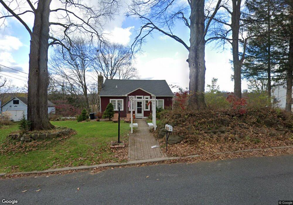
98 Wild Cat Rd Franklin, NJ 07416
Estimated Value: $376,000 - $467,000
--
Bed
--
Bath
1,960
Sq Ft
$212/Sq Ft
Est. Value
About This Home
This home is located at 98 Wild Cat Rd, Franklin, NJ 07416 and is currently estimated at $414,687, approximately $211 per square foot. 98 Wild Cat Rd is a home located in Sussex County with nearby schools including Franklin Elementary School, Wallkill Valley Regional High School, and Immaculate Conception Regional School.
Ownership History
Date
Name
Owned For
Owner Type
Purchase Details
Closed on
May 8, 2006
Sold by
Ginter William L and Ginter Kathleen F
Bought by
Ginter William L and Ginter Kathleen F
Current Estimated Value
Purchase Details
Closed on
Aug 25, 1998
Sold by
Fry Kathleen S
Bought by
Ginter William L and Ginter Kathleen F
Purchase Details
Closed on
Oct 28, 1994
Sold by
Shintay Edward J and Shintay Ellen P
Bought by
Fry Kathleen S
Create a Home Valuation Report for This Property
The Home Valuation Report is an in-depth analysis detailing your home's value as well as a comparison with similar homes in the area
Home Values in the Area
Average Home Value in this Area
Purchase History
| Date | Buyer | Sale Price | Title Company |
|---|---|---|---|
| Ginter William L | -- | None Available | |
| Garrera Frank S | -- | None Available | |
| Ginter William L | -- | -- | |
| Fry Kathleen S | $118,000 | -- |
Source: Public Records
Tax History Compared to Growth
Tax History
| Year | Tax Paid | Tax Assessment Tax Assessment Total Assessment is a certain percentage of the fair market value that is determined by local assessors to be the total taxable value of land and additions on the property. | Land | Improvement |
|---|---|---|---|---|
| 2025 | $8,307 | $338,500 | $111,800 | $226,700 |
| 2024 | $8,271 | $313,000 | $94,900 | $218,100 |
| 2023 | $8,271 | $300,000 | $88,100 | $211,900 |
| 2022 | $8,811 | $208,500 | $71,100 | $137,400 |
| 2021 | $8,557 | $208,500 | $71,100 | $137,400 |
| 2020 | $8,288 | $208,500 | $71,100 | $137,400 |
| 2019 | $7,913 | $208,500 | $71,100 | $137,400 |
| 2018 | $7,779 | $208,500 | $71,100 | $137,400 |
| 2017 | $7,589 | $208,500 | $71,100 | $137,400 |
| 2016 | $6,968 | $202,700 | $71,100 | $131,600 |
| 2015 | $6,990 | $202,700 | $71,100 | $131,600 |
| 2014 | $6,806 | $202,700 | $71,100 | $131,600 |
Source: Public Records
Map
Nearby Homes
- 10 Hemlock Dr
- 33 Maple Rd
- 149 Maple Rd
- 7 Woodland Rd
- 70 Davis Rd
- 8 Fowler St Unit 10
- 65 Buckwheat Rd
- 26 Wyker Rd Unit A
- 26 Wyker Rd Unit 2207
- 14 Sabine Ln
- 12 Davis Rd
- 69 New Jersey 23
- 52 High St
- 65 Scott Rd
- 285 Wild Cat Rd
- 112 Scott Rd
- 309 Rutherford Ave
- 76 Constitution Way Unit 76
- 76 Constitution Way Unit 534
- 66 Nestor St