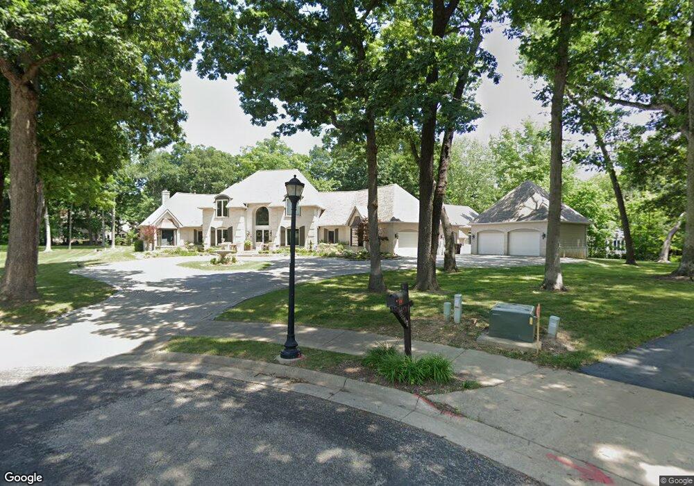
9800 N Townsend Dr Unit 3 Peoria, IL 61615
North Peoria Neighborhood
4
Beds
8
Baths
4,078
Sq Ft
1.05
Acres
About This Home
This home is located at 9800 N Townsend Dr Unit 3, Peoria, IL 61615. 9800 N Townsend Dr Unit 3 is a home located in Peoria County with nearby schools including Kellar Primary School, Liberty Leadership Middle School, and Richwoods High School.
Ownership History
Date
Name
Owned For
Owner Type
Purchase Details
Closed on
Mar 9, 2020
Sold by
Townsend Revocable Trust
Bought by
Meiss Jordan M and Meiss Miranda
Home Financials for this Owner
Home Financials are based on the most recent Mortgage that was taken out on this home.
Original Mortgage
$750,000
Outstanding Balance
$664,232
Interest Rate
3.5%
Mortgage Type
New Conventional
Purchase Details
Closed on
Jun 20, 2016
Sold by
Dean Custom Builder Inc
Bought by
Townsend Trust
Purchase Details
Closed on
Jan 13, 2014
Bought by
Dean Custom Builders Inc
Create a Home Valuation Report for This Property
The Home Valuation Report is an in-depth analysis detailing your home's value as well as a comparison with similar homes in the area
Home Values in the Area
Average Home Value in this Area
Purchase History
| Date | Buyer | Sale Price | Title Company |
|---|---|---|---|
| Meiss Jordan M | -- | None Listed On Document | |
| Townsend Trust | $738,000 | Attorney Only | |
| Dean Custom Builders Inc | $399,000 | -- |
Source: Public Records
Mortgage History
| Date | Status | Borrower | Loan Amount |
|---|---|---|---|
| Open | Meiss Jordan M | $750,000 |
Source: Public Records
Tax History Compared to Growth
Tax History
| Year | Tax Paid | Tax Assessment Tax Assessment Total Assessment is a certain percentage of the fair market value that is determined by local assessors to be the total taxable value of land and additions on the property. | Land | Improvement |
|---|---|---|---|---|
| 2024 | $23,053 | $276,010 | $33,760 | $242,250 |
| 2023 | $21,280 | $253,220 | $30,970 | $222,250 |
| 2022 | $19,238 | $227,780 | $30,170 | $197,610 |
| 2021 | $18,496 | $216,930 | $28,730 | $188,200 |
| 2020 | $18,461 | $214,790 | $28,450 | $186,340 |
| 2018 | $18,765 | $219,450 | $29,310 | $190,140 |
| 2017 | $21,236 | $245,970 | $29,610 | $216,360 |
| 2016 | $23,906 | $274,600 | $29,610 | $244,990 |
Source: Public Records
Map
Nearby Homes
- 416 W Ravinwoods Rd
- 408 W Ravinwoods Rd
- 319 W Ravinwoods Rd
- 9310 N Frye Rd
- 10019 N Spring Ln
- 1710 W Alta Rd
- 1315 W Wexford Place
- 1203 W Wexford Place
- 1319 W Wexford Place
- 0 W Alta Rd
- 634 W Mount Hawley Terrace
- 620 W Mount Hawley Terrace
- 11217 N Oakwood Dr Unit 25
- 10024 Brompton Ct
- 1205 W Poplar Woods Ct
- 10936 N Jason Dr
- 10508 N Pheasant Ln Unit B
- 1415 E Hendryx Ln
- 9716 N Broadway St
- 1606 E Hendryx Place
- 9800 N Townsend Dr
- 614 W Ravinwoods Rd
- 9804 N Townsend Dr
- 618 W Ravinwoods Rd
- 9801 N Townsend Dr
- 9705 Cherrybark Ct
- 9711 Cherrybark Ct
- 9806 N Townsend Dr
- 622 W Ravinwoods Rd
- 9805 N Townsend Dr
- 609 W Ravinwoods Rd
- 706 N Townes Ct
- 706 Townes Ct
- 619 W Ravinwoods Rd
- 726 Townes Ct
- 626 W Ravinwoods Rd
- 9809 N Townsend Dr
- 9712 Cherrybark Ct
- 9809 N Golden Oaks Ct
- 524 W Red Oak Ct