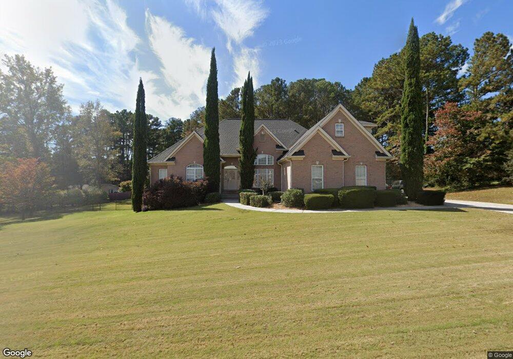
981 Jimson Dr SE Conyers, GA 30013
Estimated Value: $408,000 - $489,000
4
Beds
4
Baths
2,664
Sq Ft
$169/Sq Ft
Est. Value
About This Home
This home is located at 981 Jimson Dr SE, Conyers, GA 30013 and is currently estimated at $449,478, approximately $168 per square foot. 981 Jimson Dr SE is a home located in Rockdale County with nearby schools including Flat Shoals Elementary School, Memorial Middle School, and Rockdale County High School.
Ownership History
Date
Name
Owned For
Owner Type
Purchase Details
Closed on
Oct 1, 2024
Sold by
Harrison Joseph N
Bought by
Harrison Joseph Noel Jr Tr and Harrison Susie Fuller Tr
Current Estimated Value
Purchase Details
Closed on
May 29, 2001
Sold by
Gupta Inder J and Gupta Urmila B
Bought by
Harrison Joseph N and Harrison Susie F
Home Financials for this Owner
Home Financials are based on the most recent Mortgage that was taken out on this home.
Original Mortgage
$253,800
Interest Rate
7.11%
Mortgage Type
New Conventional
Create a Home Valuation Report for This Property
The Home Valuation Report is an in-depth analysis detailing your home's value as well as a comparison with similar homes in the area
Home Values in the Area
Average Home Value in this Area
Purchase History
| Date | Buyer | Sale Price | Title Company |
|---|---|---|---|
| Harrison Joseph Noel Jr Tr | -- | -- | |
| Harrison Joseph N | $46,000 | -- |
Source: Public Records
Mortgage History
| Date | Status | Borrower | Loan Amount |
|---|---|---|---|
| Previous Owner | Harrison Joseph N | $253,800 |
Source: Public Records
Tax History Compared to Growth
Tax History
| Year | Tax Paid | Tax Assessment Tax Assessment Total Assessment is a certain percentage of the fair market value that is determined by local assessors to be the total taxable value of land and additions on the property. | Land | Improvement |
|---|---|---|---|---|
| 2024 | $4,291 | $197,080 | $39,400 | $157,680 |
| 2023 | $3,759 | $184,160 | $35,240 | $148,920 |
| 2022 | $3,946 | $179,200 | $35,240 | $143,960 |
| 2021 | $3,237 | $143,160 | $25,200 | $117,960 |
| 2020 | $2,981 | $129,520 | $24,560 | $104,960 |
| 2019 | $2,618 | $114,960 | $15,000 | $99,960 |
| 2018 | $2,634 | $114,960 | $15,000 | $99,960 |
| 2017 | $2,407 | $106,680 | $15,000 | $91,680 |
| 2016 | $1,812 | $93,800 | $15,880 | $77,920 |
| 2015 | $1,812 | $93,800 | $15,880 | $77,920 |
| 2014 | $1,495 | $91,320 | $13,400 | $77,920 |
| 2013 | -- | $118,240 | $21,600 | $96,640 |
Source: Public Records
Map
Nearby Homes
- 952 Jimson Dr SE
- 1242 Saxony Dr SE
- 1408 Aramore Dr SE
- 2197 Boxwood Cir
- 2474 Harvest Dr SE
- 1135 Vineyard Dr SE
- Astrid Plan at Alder Park
- Harrison Plan at Alder Park
- Baker Plan at Alder Park
- Oliver Plan at Alder Park
- 2130 Weatherstone Cir SE
- Boston Plan at Millers Pointe
- 1911 Colestock Ave SE
- Atlanta Plan at Millers Pointe
- Columbus Plan at Millers Pointe
- 2464 Lennox Rd SE
- 1180 Azalea Cir SE
- 784 Stieff Ct SE
- 2165 Old Salem Rd SE
- 2608 Downing Park Dr SE
- 971 Jimson Dr SE Unit 5
- 982 Jimson Dr SE
- 991 Jimson Dr SE
- 2320 Highway 20 SE
- 2320 Georgia 20
- 972 Jimson Dr SE Unit 5
- 961 Jimson Dr SE
- 1001 Jimson Dr SE
- 992 Jimson Dr SE Unit 5
- 1015 Henna Ct SE
- 962 Jimson Dr SE
- 1004 Vineyard Dr SE
- 1011 Jimson Dr SE
- 982 Vineyard Dr SE
- 0 Jimson Dr SE Unit 7454220
- 0 Jimson Dr SE Unit 7203546
- 0 Jimson Dr SE Unit 8105652
- 0 Jimson Dr SE Unit 7432696
- 0 Jimson Dr SE
- 1017 Henna Ct SE Unit 5