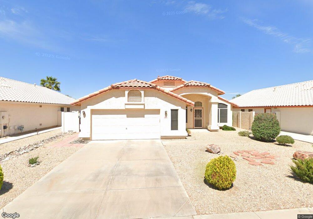
9842 W Mohawk Ln Peoria, AZ 85382
Estimated Value: $408,550 - $480,000
--
Bed
3
Baths
1,828
Sq Ft
$250/Sq Ft
Est. Value
About This Home
This home is located at 9842 W Mohawk Ln, Peoria, AZ 85382 and is currently estimated at $457,138, approximately $250 per square foot. 9842 W Mohawk Ln is a home located in Maricopa County with nearby schools including Parkridge Elementary School and Sunrise Mountain High School.
Ownership History
Date
Name
Owned For
Owner Type
Purchase Details
Closed on
Aug 29, 1996
Sold by
Continental Homes Inc
Bought by
Bryant Loyd and Bryant Loreen
Current Estimated Value
Home Financials for this Owner
Home Financials are based on the most recent Mortgage that was taken out on this home.
Original Mortgage
$120,500
Outstanding Balance
$10,375
Interest Rate
8.23%
Mortgage Type
VA
Estimated Equity
$446,763
Create a Home Valuation Report for This Property
The Home Valuation Report is an in-depth analysis detailing your home's value as well as a comparison with similar homes in the area
Home Values in the Area
Average Home Value in this Area
Purchase History
| Date | Buyer | Sale Price | Title Company |
|---|---|---|---|
| Bryant Loyd | $117,049 | First American Title | |
| Continental Homes Inc | -- | First American Title |
Source: Public Records
Mortgage History
| Date | Status | Borrower | Loan Amount |
|---|---|---|---|
| Open | Bryant Loyd | $120,500 |
Source: Public Records
Tax History Compared to Growth
Tax History
| Year | Tax Paid | Tax Assessment Tax Assessment Total Assessment is a certain percentage of the fair market value that is determined by local assessors to be the total taxable value of land and additions on the property. | Land | Improvement |
|---|---|---|---|---|
| 2025 | $1,658 | $21,391 | -- | -- |
| 2024 | $1,677 | $20,373 | -- | -- |
| 2023 | $1,677 | $33,020 | $6,600 | $26,420 |
| 2022 | $1,642 | $25,370 | $5,070 | $20,300 |
| 2021 | $1,754 | $23,380 | $4,670 | $18,710 |
| 2020 | $1,772 | $22,210 | $4,440 | $17,770 |
| 2019 | $1,716 | $20,470 | $4,090 | $16,380 |
| 2018 | $1,644 | $19,520 | $3,900 | $15,620 |
| 2017 | $1,648 | $17,900 | $3,580 | $14,320 |
| 2016 | $1,598 | $17,210 | $3,440 | $13,770 |
| 2015 | $1,521 | $16,550 | $3,310 | $13,240 |
Source: Public Records
Map
Nearby Homes
- 9729 W Burnett Rd
- 10001 W Potter Dr
- 20967 N 96th Ln
- 9818 W Pontiac Dr
- 20961 N 96th Dr
- 20640 N 100th Ln
- 20424 N 96th Ln
- 9901 W Mescalero Ct
- 10169 W Potter Dr
- 9869 W Chino Dr
- 19838 N Pine Springs Dr
- 9561 W Frank Ave
- 9832 W Behrend Dr
- 10134 W Pine Springs Dr
- 9717 W Marco Polo Rd
- 9541 W Frank Ave
- 9582 W Albert Ln
- 19702 N 98th Ln
- 19829 N Lake Forest Dr
- 9574 W Quail Ave
- 9836 W Mohawk Ln
- 9848 W Mohawk Ln
- 9830 W Mohawk Ln
- 9835 W Burnett Rd
- 9847 W Burnett Rd
- 9841 W Mohawk Ln
- 9829 W Burnett Rd
- 9847 W Mohawk Ln
- 9835 W Mohawk Ln
- 9853 W Mohawk Ln
- 9824 W Mohawk Ln
- 20616 N 98th Ln
- 20626 N 98th Ln
- 9823 W Burnett Rd
- 20636 N 98th Ln
- 9859 W Mohawk Ln
- 9818 W Mohawk Ln
- 9823 W Mohawk Ln
- 20646 N 98th Ln
- 9842 W Runion Dr