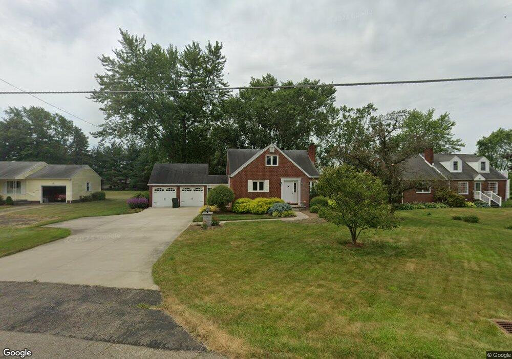
9848 Louisville St Louisville, OH 44641
Estimated Value: $211,000 - $233,000
3
Beds
2
Baths
1,666
Sq Ft
$133/Sq Ft
Est. Value
About This Home
This home is located at 9848 Louisville St, Louisville, OH 44641 and is currently estimated at $222,155, approximately $133 per square foot. 9848 Louisville St is a home located in Stark County with nearby schools including Louisville High School and St. Thomas Aquinas High School & Middle School.
Ownership History
Date
Name
Owned For
Owner Type
Purchase Details
Closed on
Apr 21, 1998
Sold by
Fisher Bruce C
Bought by
Ring John and Muntz Constance
Current Estimated Value
Home Financials for this Owner
Home Financials are based on the most recent Mortgage that was taken out on this home.
Original Mortgage
$88,400
Outstanding Balance
$17,031
Interest Rate
7.27%
Mortgage Type
New Conventional
Estimated Equity
$205,124
Purchase Details
Closed on
Oct 24, 1991
Create a Home Valuation Report for This Property
The Home Valuation Report is an in-depth analysis detailing your home's value as well as a comparison with similar homes in the area
Home Values in the Area
Average Home Value in this Area
Purchase History
| Date | Buyer | Sale Price | Title Company |
|---|---|---|---|
| Ring John | $110,500 | -- | |
| -- | $72,000 | -- |
Source: Public Records
Mortgage History
| Date | Status | Borrower | Loan Amount |
|---|---|---|---|
| Open | Ring John | $88,400 |
Source: Public Records
Tax History Compared to Growth
Tax History
| Year | Tax Paid | Tax Assessment Tax Assessment Total Assessment is a certain percentage of the fair market value that is determined by local assessors to be the total taxable value of land and additions on the property. | Land | Improvement |
|---|---|---|---|---|
| 2025 | -- | $68,360 | $15,400 | $52,960 |
| 2024 | -- | $68,360 | $15,400 | $52,960 |
| 2023 | $2,338 | $48,100 | $10,890 | $37,210 |
| 2022 | $1,172 | $48,100 | $10,890 | $37,210 |
| 2021 | $2,351 | $48,100 | $10,890 | $37,210 |
| 2020 | $1,995 | $43,120 | $9,800 | $33,320 |
| 2019 | $2,003 | $43,120 | $9,800 | $33,320 |
| 2018 | $1,997 | $43,120 | $9,800 | $33,320 |
| 2017 | $1,939 | $39,970 | $9,170 | $30,800 |
| 2016 | $1,987 | $41,900 | $9,170 | $32,730 |
| 2015 | $1,992 | $41,900 | $9,170 | $32,730 |
| 2014 | $1,879 | $36,550 | $8,020 | $28,530 |
| 2013 | $943 | $36,550 | $8,020 | $28,530 |
Source: Public Records
Map
Nearby Homes
- 2015 E Main St
- 2110 Edmar St
- 5495 Meese Rd NE
- 1812 E Broad St
- 5765 Maplegrove St
- 1715 High St
- 3390 Meese Rd NE
- 0 Michigan Blvd
- 641 S Nickelplate St
- 6052 N Nickelplate St
- 308 Superior St
- 520 S Silver St
- 1170 Winding Ridge Ave
- 728 E Broad St
- 910 Crosswyck Cir
- 908 Sand Lot Cir
- 325 Lincoln Ave
- 8225 Georgetown St
- 204 E Broad St
- 510 S Bauman Ct
- 9828 Louisville St
- 9864 Louisville St
- 9894 Louisville St
- 9861 Louisville St
- 9833 Louisville St
- 9871 Parkgrove St
- 9821 Louisville St
- 9891 Louisville St
- 9916 Louisville St
- 4455 Foster Dr
- 9776 Louisville St NE
- 9776 Louisville St
- 9919 Louisville St
- 9777 Louisville St
- 4500 Lakeknoll St
- 4465 Foster Dr
- 9938 Louisville St
- 4474 Foster Dr
- 4501 Foster Dr
- 4516 Lakeknoll St