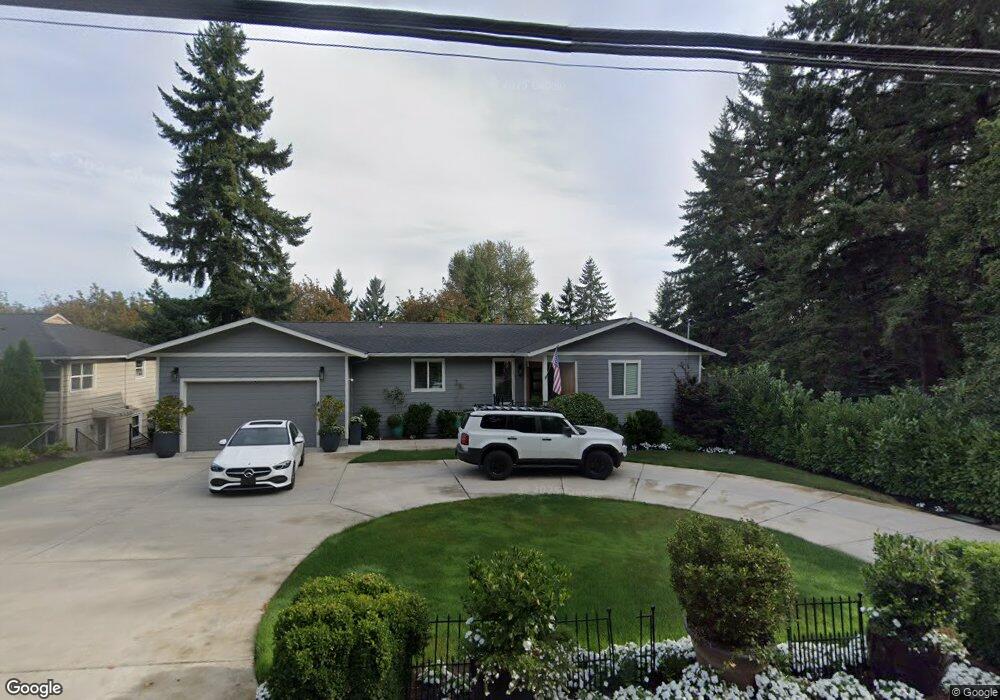
985 Southshore Blvd Lake Oswego, OR 97034
McVey-South Shore NeighborhoodEstimated Value: $1,089,000 - $1,559,000
4
Beds
3
Baths
2,732
Sq Ft
$465/Sq Ft
Est. Value
About This Home
This home is located at 985 Southshore Blvd, Lake Oswego, OR 97034 and is currently estimated at $1,271,233, approximately $465 per square foot. 985 Southshore Blvd is a home located in Clackamas County with nearby schools including Hallinan Elementary School, Lakeridge Middle School, and Lakeridge High School.
Ownership History
Date
Name
Owned For
Owner Type
Purchase Details
Closed on
Jun 29, 2021
Sold by
Barr Philip and Barr Caynthia
Bought by
Amb Invetsments Llc
Current Estimated Value
Purchase Details
Closed on
Dec 31, 2019
Sold by
James Jacqueline A and James Redvers J
Bought by
Barr Phillip M and Barr Cynthia L
Home Financials for this Owner
Home Financials are based on the most recent Mortgage that was taken out on this home.
Original Mortgage
$281,250
Interest Rate
3.7%
Mortgage Type
New Conventional
Create a Home Valuation Report for This Property
The Home Valuation Report is an in-depth analysis detailing your home's value as well as a comparison with similar homes in the area
Home Values in the Area
Average Home Value in this Area
Purchase History
| Date | Buyer | Sale Price | Title Company |
|---|---|---|---|
| Amb Invetsments Llc | -- | None Available | |
| Amb Investments Llc | -- | None Available | |
| Barr Phillip M | $375,000 | Fidelity National Ttl Of Or |
Source: Public Records
Mortgage History
| Date | Status | Borrower | Loan Amount |
|---|---|---|---|
| Previous Owner | Barr Phillip M | $281,250 |
Source: Public Records
Tax History Compared to Growth
Tax History
| Year | Tax Paid | Tax Assessment Tax Assessment Total Assessment is a certain percentage of the fair market value that is determined by local assessors to be the total taxable value of land and additions on the property. | Land | Improvement |
|---|---|---|---|---|
| 2025 | $11,223 | $585,688 | -- | -- |
| 2024 | $10,924 | $568,630 | -- | -- |
| 2023 | $10,924 | $552,068 | $0 | $0 |
| 2022 | $7,895 | $411,292 | $0 | $0 |
| 2021 | $6,060 | $331,873 | $0 | $0 |
| 2020 | $5,907 | $322,207 | $0 | $0 |
| 2019 | $5,762 | $312,823 | $0 | $0 |
| 2018 | $5,479 | $303,712 | $0 | $0 |
| 2017 | $5,287 | $294,866 | $0 | $0 |
| 2016 | $4,813 | $286,278 | $0 | $0 |
| 2015 | $4,649 | $277,940 | $0 | $0 |
| 2014 | $4,590 | $269,845 | $0 | $0 |
Source: Public Records
Map
Nearby Homes
- 1015 Southshore Blvd
- 1093 Tyndall Ct
- 1224 Tyndall Ct
- 1300 Tyndall Ct
- 1405 Cherry Crest Ave
- 800 Terrace Dr
- 1520 Cherry Crest Ave
- 1410 Woodland Terrace
- 1872 Palisades Terrace Dr
- 1865 Palisades Lake Ct
- 1467 Greentree Cir
- 1725 Southshore Blvd
- 731 Clara Ct
- 1710 S Shore Blvd
- 1720 Kilkenny Dr
- 1847 Woodland Terrace
- 1527 Lake Front Rd
- 1535 Larch St
- 1750 N Shore Rd
- 15400 Diamond Head Rd
- 975 Southshore Blvd
- 995 SW South Shore
- 995 SW South Shore Blvd
- 995 Southshore Blvd
- 1005 Southshore Blvd
- 965 Southshore Blvd
- 865 Palisades Terrace Dr
- 845 Palisades Terrace Dr
- 1010 Oak Terrace
- 980 Oak Terrace
- 1040 Oak Terrace
- 875 Palisades Terrace Dr
- 1015 S Shore Blvd
- 950 Oak Terrace
- 1070 Oak Terrace
- 16570 Woodsman Ct
- 835 Palisades Terrace Dr
- 1159 Tyndall Ct
- 1100 Oak Terrace
- 920 Oak Terrace