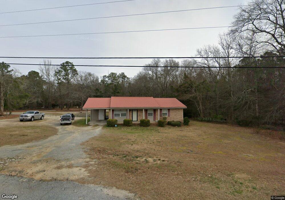
986 Salem Rd Thomson, GA 30824
Estimated Value: $173,271 - $212,000
3
Beds
2
Baths
1,247
Sq Ft
$153/Sq Ft
Est. Value
About This Home
This home is located at 986 Salem Rd, Thomson, GA 30824 and is currently estimated at $191,068, approximately $153 per square foot. 986 Salem Rd is a home located in McDuffie County with nearby schools including Thomson High School.
Ownership History
Date
Name
Owned For
Owner Type
Purchase Details
Closed on
Aug 21, 2012
Sold by
Darby Ann D
Bought by
Brundage Jerome and Brundage Samantha
Current Estimated Value
Home Financials for this Owner
Home Financials are based on the most recent Mortgage that was taken out on this home.
Original Mortgage
$75,000
Outstanding Balance
$51,240
Interest Rate
3.53%
Mortgage Type
New Conventional
Estimated Equity
$139,828
Purchase Details
Closed on
Apr 16, 1979
Bought by
Powell Ann D
Create a Home Valuation Report for This Property
The Home Valuation Report is an in-depth analysis detailing your home's value as well as a comparison with similar homes in the area
Home Values in the Area
Average Home Value in this Area
Purchase History
| Date | Buyer | Sale Price | Title Company |
|---|---|---|---|
| Brundage Jerome | $75,000 | -- | |
| Powell Ann D | -- | -- |
Source: Public Records
Mortgage History
| Date | Status | Borrower | Loan Amount |
|---|---|---|---|
| Open | Brundage Jerome | $75,000 |
Source: Public Records
Tax History Compared to Growth
Tax History
| Year | Tax Paid | Tax Assessment Tax Assessment Total Assessment is a certain percentage of the fair market value that is determined by local assessors to be the total taxable value of land and additions on the property. | Land | Improvement |
|---|---|---|---|---|
| 2025 | $1,464 | $66,220 | $6,076 | $60,144 |
| 2024 | $1,464 | $62,351 | $5,246 | $57,105 |
| 2023 | $1,425 | $59,726 | $4,980 | $54,746 |
| 2022 | $1,266 | $51,030 | $3,320 | $47,710 |
| 2021 | $1,005 | $40,423 | $3,320 | $37,103 |
| 2020 | $745 | $30,420 | $3,002 | $27,418 |
| 2019 | $753 | $30,420 | $3,002 | $27,418 |
| 2018 | $753 | $30,420 | $3,002 | $27,418 |
| 2017 | $726 | $30,420 | $3,002 | $27,418 |
| 2016 | $726 | $30,420 | $3,002 | $27,418 |
| 2015 | $726 | $32,981 | $3,002 | $29,980 |
| 2014 | $727 | $32,982 | $3,002 | $29,980 |
| 2013 | -- | $32,981 | $3,001 | $29,980 |
Source: Public Records
Map
Nearby Homes
- 415 Stonewall Dr
- 416 Forrest Clary Dr
- 1008 Wrens Hwy
- 306 Michael St
- 709 Pine Lane Dr
- 421 Salem Rd
- 0 Wrens Hwy Unit 10652460
- 0 Wrens Hwy Unit 549833
- 118 Langham St
- 629 Clary St
- A-00 Harrison Rd
- 609 Hillcrest Dr
- 2057 April Dawn Trail
- 2084 April Dawn Trail
- 2099 April Dawn Trail
- 2051 April Dawn Trail
- 2145 April Dawn Trail
- 2090 April Dawn Trail