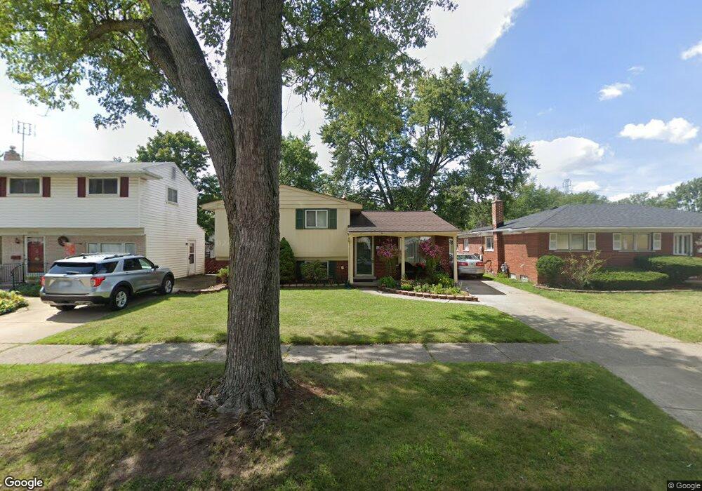
9886 Cass Ave Taylor, MI 48180
Estimated Value: $242,968 - $260,000
3
Beds
2
Baths
1,687
Sq Ft
$151/Sq Ft
Est. Value
About This Home
This home is located at 9886 Cass Ave, Taylor, MI 48180 and is currently estimated at $254,742, approximately $151 per square foot. 9886 Cass Ave is a home located in Wayne County with nearby schools including Kinyon Elementary School, Robert J. West Middle School, and Taylor High School.
Ownership History
Date
Name
Owned For
Owner Type
Purchase Details
Closed on
Aug 10, 2012
Sold by
Daugherty Bobby and Daugherty Phyllis
Bought by
Daugherty Bobby and Daugherty Ryan
Current Estimated Value
Purchase Details
Closed on
Jul 30, 2012
Sold by
Frank Scott and Frank Karen
Bought by
Daugherty Bobby
Purchase Details
Closed on
Jun 27, 2002
Sold by
Kuzia Sally E
Bought by
Frank Scott
Purchase Details
Closed on
Oct 10, 1998
Sold by
Ruzia David A
Bought by
Kuzia Sally E
Purchase Details
Closed on
Jun 3, 1996
Sold by
David A Kuzia and David Sally E
Bought by
Grabowski Gerard L Grabowski
Create a Home Valuation Report for This Property
The Home Valuation Report is an in-depth analysis detailing your home's value as well as a comparison with similar homes in the area
Home Values in the Area
Average Home Value in this Area
Purchase History
We collect this data history from publicly available records. To have your information removed, we recommend requesting removal directly through your county’s website.
| Date | Buyer | Sale Price | Title Company |
|---|---|---|---|
| Daugherty Bobby | -- | First American Title Ins Co | |
| Daugherty Bobby | $69,100 | First American Title | |
| Frank Scott | $149,000 | -- | |
| Kuzia Sally E | -- | -- | |
| Grabowski Gerard L Grabowski | $99,900 | -- |
Source: Public Records
Tax History
| Year | Tax Paid | Tax Assessment Tax Assessment Total Assessment is a certain percentage of the fair market value that is determined by local assessors to be the total taxable value of land and additions on the property. | Land | Improvement |
|---|---|---|---|---|
| 2025 | $2,527 | $106,500 | $0 | $0 |
| 2024 | $2,447 | $99,200 | $0 | $0 |
| 2023 | $3,056 | $87,300 | $0 | $0 |
| 2022 | $2,336 | $78,700 | $0 | $0 |
| 2021 | $2,591 | $71,900 | $0 | $0 |
| 2020 | $2,554 | $64,700 | $0 | $0 |
| 2019 | $254,260 | $54,600 | $0 | $0 |
| 2018 | $2,006 | $54,000 | $0 | $0 |
| 2017 | $3,984 | $50,600 | $0 | $0 |
| 2016 | $2,570 | $49,100 | $0 | $0 |
| 2015 | $4,531 | $46,300 | $0 | $0 |
| 2013 | $4,510 | $47,000 | $0 | $0 |
| 2012 | $1,996 | $45,500 | $11,000 | $34,500 |
Source: Public Records
Map
Nearby Homes
- 9749 Sylvester St
- 9651 Blaty St
- 9560 Sylvester St
- 22243 Kinyon St Unit 3
- 22243 Kinyon St Unit 1
- 9788 Pine St
- 011 Pine St
- 01 Pine St
- 9228 Mueller St
- 9731 Cornell St
- 9615 Cornell St
- 22327 Wick Rd
- 9602 Cornell St
- 10769 Birch St
- 9606 Cornell St
- 22311 Wick Rd
- 9360 Pine St
- 22021 Rosemary St
- 6445 Pardee Rd
- 9981 Telegraph Rd
- 9898 Cass Ave
- 9874 Cass Ave
- 9862 Cass Ave
- 23026 Leslie St
- 23012 Leslie St
- 9903 Mueller St
- 9915 Mueller St
- 9795 Mueller St
- 23038 Leslie St
- 9850 Cass Ave
- 9787 Mueller St
- 9885 Cass Ave
- 9935 Mueller St
- 9897 Cass Ave
- 9873 Cass Ave
- 9838 Cass Ave
- 22948 Leslie St
- 9779 Mueller St
- 9861 Cass Ave
- 9769 Mueller St
Your Personal Tour Guide
Ask me questions while you tour the home.