Estimated Value: $129,109 - $161,000
3
Beds
2
Baths
1,066
Sq Ft
$141/Sq Ft
Est. Value
About This Home
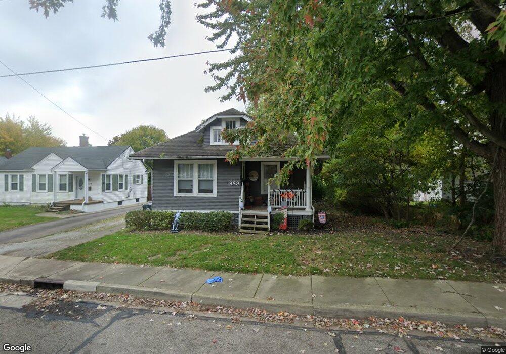
This home is located at 989 S Monroe St, Xenia, OH 45385 and is currently estimated at $149,777, approximately $140 per square foot. 989 S Monroe St is a home located in Greene County with nearby schools including Xenia High School, Summit Academy Community School for Alternative Learners - Xenia, and Legacy Christian Academy.
Ownership History
Date
Name
Owned For
Owner Type
Purchase Details
Closed on
Nov 18, 2005
Sold by
Cassity Daniel W
Bought by
Bassett Carrie E and Ward Matthew Blanding
Current Estimated Value
Home Financials for this Owner
Home Financials are based on the most recent Mortgage that was taken out on this home.
Original Mortgage
$76,000
Outstanding Balance
$41,972
Interest Rate
6.17%
Mortgage Type
Unknown
Estimated Equity
$107,805
Purchase Details
Closed on
Jun 8, 2005
Sold by
Sky Bank
Bought by
Cassity Daniel W
Purchase Details
Closed on
Dec 26, 1995
Sold by
Shackleford Kristine K
Bought by
Botts Aaron T and Botts J
Home Financials for this Owner
Home Financials are based on the most recent Mortgage that was taken out on this home.
Original Mortgage
$48,159
Interest Rate
7.43%
Mortgage Type
FHA
Create a Home Valuation Report for This Property
The Home Valuation Report is an in-depth analysis detailing your home's value as well as a comparison with similar homes in the area
Home Values in the Area
Average Home Value in this Area
Purchase History
| Date | Buyer | Sale Price | Title Company |
|---|---|---|---|
| Bassett Carrie E | $76,000 | -- | |
| Cassity Daniel W | $36,000 | -- | |
| Botts Aaron T | $48,500 | -- |
Source: Public Records
Mortgage History
| Date | Status | Borrower | Loan Amount |
|---|---|---|---|
| Open | Bassett Carrie E | $76,000 | |
| Previous Owner | Botts Aaron T | $48,159 |
Source: Public Records
Tax History Compared to Growth
Tax History
| Year | Tax Paid | Tax Assessment Tax Assessment Total Assessment is a certain percentage of the fair market value that is determined by local assessors to be the total taxable value of land and additions on the property. | Land | Improvement |
|---|---|---|---|---|
| 2024 | $1,332 | $31,120 | $3,780 | $27,340 |
| 2023 | $1,332 | $31,120 | $3,780 | $27,340 |
| 2022 | $1,169 | $23,300 | $3,030 | $20,270 |
| 2021 | $1,155 | $23,300 | $3,030 | $20,270 |
| 2020 | $1,105 | $23,300 | $3,030 | $20,270 |
| 2019 | $942 | $18,700 | $2,880 | $15,820 |
| 2018 | $946 | $18,700 | $2,880 | $15,820 |
| 2017 | $964 | $18,700 | $2,880 | $15,820 |
| 2016 | $964 | $18,710 | $2,880 | $15,830 |
| 2015 | $967 | $18,710 | $2,880 | $15,830 |
| 2014 | $925 | $18,710 | $2,880 | $15,830 |
Source: Public Records
Map
Nearby Homes
- 979 Mcdowell St
- 260 Pocahontas St
- 46 Lake St
- 847 S Detroit St
- 55 Lake St
- 148 Home Ave
- 222 Washington St
- 633 Xenia Ave
- 400 S Detroit St
- 293 S Miami Ave
- 104 Ledbetter Rd
- 36 Leaman St
- 98 W 3rd St
- 75 W 2nd St
- 733 State Route 380
- 654 E 3rd St
- 523 Newport Rd
- 541 E Main St
- 607 E Main St
- 305-325 Bellbrook Ave
- 1005 S Monroe St
- 979 S Monroe St
- 1015 S Monroe St
- 969 S Monroe St
- 1023 S Monroe St
- 992 S Monroe St
- 998 S Monroe St
- 1004 S Monroe St
- 959 S Monroe St
- 980 S Monroe St
- 972 S Monroe St
- 1035 S Monroe St
- 1014 S Monroe St
- 951 S Monroe St
- 960 S Monroe St
- 1024 S Monroe St
- 943 Mcdowell St
- 943 Mcdowell St
- 943 Mcdowell St
- 948 S Monroe St