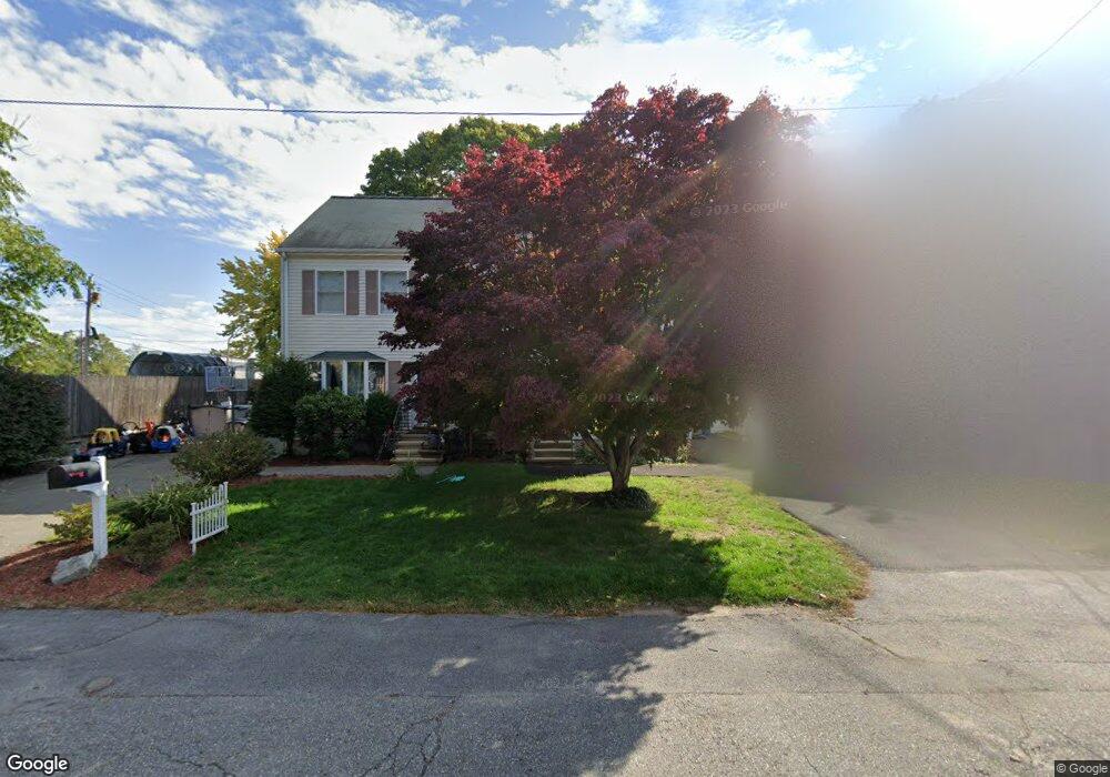
99 Fiske St Waltham, MA 02451
Bank Square NeighborhoodEstimated Value: $652,000 - $693,991
3
Beds
2
Baths
1,680
Sq Ft
$405/Sq Ft
Est. Value
About This Home
This home is located at 99 Fiske St, Waltham, MA 02451 and is currently estimated at $680,498, approximately $405 per square foot. 99 Fiske St is a home located in Middlesex County with nearby schools including Thomas R Plympton Elementary School, John F Kennedy Middle School, and Waltham Sr High School.
Ownership History
Date
Name
Owned For
Owner Type
Purchase Details
Closed on
Jan 23, 2004
Sold by
Gildea & Sons Inc
Bought by
Brown Alan and Brown Joan D
Current Estimated Value
Purchase Details
Closed on
May 29, 1997
Sold by
Gildea & Sons Inc
Bought by
Nesline Diane S
Home Financials for this Owner
Home Financials are based on the most recent Mortgage that was taken out on this home.
Original Mortgage
$133,900
Interest Rate
8.09%
Mortgage Type
Purchase Money Mortgage
Create a Home Valuation Report for This Property
The Home Valuation Report is an in-depth analysis detailing your home's value as well as a comparison with similar homes in the area
Home Values in the Area
Average Home Value in this Area
Purchase History
| Date | Buyer | Sale Price | Title Company |
|---|---|---|---|
| Brown Alan | -- | -- | |
| Nesline Diane S | $168,900 | -- |
Source: Public Records
Mortgage History
| Date | Status | Borrower | Loan Amount |
|---|---|---|---|
| Open | Nesline Diane S | $280,000 | |
| Closed | Nesline Diane S | $251,000 | |
| Previous Owner | Nesline Diane S | $133,900 |
Source: Public Records
Tax History Compared to Growth
Tax History
| Year | Tax Paid | Tax Assessment Tax Assessment Total Assessment is a certain percentage of the fair market value that is determined by local assessors to be the total taxable value of land and additions on the property. | Land | Improvement |
|---|---|---|---|---|
| 2025 | $5,354 | $545,200 | $0 | $545,200 |
| 2024 | $5,127 | $531,800 | $0 | $531,800 |
| 2023 | $5,278 | $511,400 | $0 | $511,400 |
| 2022 | $5,541 | $497,400 | $0 | $497,400 |
| 2021 | $5,315 | $469,500 | $0 | $469,500 |
| 2020 | $5,697 | $476,700 | $0 | $476,700 |
| 2019 | $5,297 | $418,400 | $0 | $418,400 |
| 2018 | $5,276 | $418,400 | $0 | $418,400 |
| 2017 | $4,174 | $332,300 | $0 | $332,300 |
| 2016 | $4,067 | $332,300 | $0 | $332,300 |
| 2015 | $4,318 | $328,900 | $0 | $328,900 |
Source: Public Records
Map
Nearby Homes
- 15 Howard St
- 43-45 Welligton Unit 3
- 160 School St Unit 3-1
- 32 Harvard St Unit 2
- 91 Prentice St
- 15 Banks St Unit 4
- 37 Summit St
- 39 Floyd St Unit 2
- 948 Main St Unit 209
- 948 Main St Unit 105
- 251 Bacon St
- 14 Claremont St
- 7-11.5 Felton
- 31 Weston St Unit 2
- 70 School St
- 79-81 Vernon St
- 326 Bacon St
- 14 Willard St
- 158 Church St
- 55-57 Crescent St
- 99 Fiske St Unit 99
- 99 Fiske St Unit 99,0
- 101 Fiske St
- 101 Fiske St Unit 101,101
- 97 Fiske St
- 95 Fiske St
- 97 Fiske St Unit 97
- 95 Fiske St Unit 95,00
- 97 Fiske St Unit 97,0
- 98 Fiske St
- 94 Bacon St Unit 4
- 94 Bacon St
- 89 Fiske St Unit 91
- 89 Fiske St Unit 2
- 89 Fiske St Unit 1
- 91 Fiske St Unit 1
- 85 Fiske St Unit 87
- 85 Fiske St Unit 1
- 87 Fiske St Unit 87
- 7 Joy St