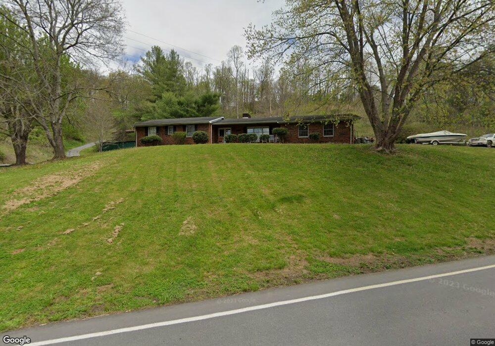
99 Long Branch Rd Unit Lot 2 Marshall, NC 28753
Estimated Value: $455,000 - $500,145
--
Bed
--
Bath
1,572
Sq Ft
$301/Sq Ft
Est. Value
About This Home
This home is located at 99 Long Branch Rd Unit Lot 2, Marshall, NC 28753 and is currently estimated at $472,715, approximately $300 per square foot. 99 Long Branch Rd Unit Lot 2 is a home located in Madison County with nearby schools including Madison Middle School.
Ownership History
Date
Name
Owned For
Owner Type
Purchase Details
Closed on
Aug 20, 2017
Sold by
Boyette Renee Wyatt
Bought by
Boyette Renee Wyatt
Current Estimated Value
Purchase Details
Closed on
Jul 19, 2017
Sold by
Sluders Of Wnc Llc
Bought by
Sluder Marilyn Wyatt
Purchase Details
Closed on
Feb 28, 2014
Sold by
Edwards Wanda F
Bought by
Edwards Wanda F and Boyette Renee Wyatt
Purchase Details
Closed on
Feb 7, 2006
Sold by
Bulls Bay Llc
Bought by
Mercer Joseph and Mercer Lori
Home Financials for this Owner
Home Financials are based on the most recent Mortgage that was taken out on this home.
Original Mortgage
$131,400
Interest Rate
6.87%
Mortgage Type
Adjustable Rate Mortgage/ARM
Create a Home Valuation Report for This Property
The Home Valuation Report is an in-depth analysis detailing your home's value as well as a comparison with similar homes in the area
Home Values in the Area
Average Home Value in this Area
Purchase History
| Date | Buyer | Sale Price | Title Company |
|---|---|---|---|
| Boyette Renee Wyatt | -- | None Available | |
| Sluder Marilyn Wyatt | -- | None Available | |
| Edwards Wanda F | -- | Chicago Title Insurance Co | |
| Mercer Joseph | $146,000 | None Available |
Source: Public Records
Mortgage History
| Date | Status | Borrower | Loan Amount |
|---|---|---|---|
| Previous Owner | Mercer Joseph | $131,400 |
Source: Public Records
Tax History Compared to Growth
Tax History
| Year | Tax Paid | Tax Assessment Tax Assessment Total Assessment is a certain percentage of the fair market value that is determined by local assessors to be the total taxable value of land and additions on the property. | Land | Improvement |
|---|---|---|---|---|
| 2024 | $1,726 | $351,388 | $131,917 | $219,471 |
| 2023 | $1,454 | $250,755 | $101,810 | $148,945 |
| 2022 | $1,454 | $250,755 | $101,810 | $148,945 |
| 2021 | $1,454 | $250,755 | $101,810 | $148,945 |
| 2020 | $1,254 | $250,755 | $101,810 | $148,945 |
| 2019 | $1,107 | $201,192 | $78,738 | $122,454 |
| 2018 | $1,207 | $0 | $0 | $0 |
| 2017 | $1,229 | $0 | $0 | $0 |
| 2016 | $1,229 | $0 | $0 | $0 |
| 2015 | -- | $0 | $0 | $0 |
| 2014 | -- | $204,892 | $78,738 | $126,154 |
| 2013 | -- | $209,924 | $78,738 | $131,186 |
Source: Public Records
Map
Nearby Homes
- 461 Tweed Rd
- ### N Long Branch Rd Unit 2
- 1395 Tillery Branch Rd
- Lot 2 Lunsford Ln
- 366 Cabin Hollow Dr
- 730 Silver Mill Rd
- 0 Anderson Cove Rd
- 1542 Tillery Branch Rd
- 1126 Rector Corner Rd
- 55 Webb Dr
- 55 & 119 Webb Dr
- 153 Skyway Dr
- 456 Rector Corner Rd
- 2912 Windswept Ridge Rd
- 2200 Walnut Creek Rd
- 849 S Ammons Branch Rd
- 131 Ivy Bluffs Rd Unit 3
- 999 Baileys Branch Rd Unit 3
- 1623 Ammons Branch Rd
- 1927 Ammons Branch Rd
- 99 Long Branch Rd
- 99 Long Branch Rd Unit Lot 5
- 99 Long Branch Rd Unit Lot 6
- 99 Long Branch Rd Unit Lot 3
- 79 Long Branch Rd
- 4226 Us 25/70 Hwy
- 4386 Us 25/70 Hwy
- 4223 Us 25/70 Hwy
- Lot #4 Crossing Pkwy Unit 4
- 1210 Hayes Run Rd
- 160 Fore Rd
- 34 Buckeye Ridge
- 181 Fore Rd
- 1202 Hayes Run Rd
- 0000 Hwy 213
- 000 Hwy 213
- 00 Hwy 213
- 1185 Hayes Run Rd
- 1251 Hayes Run Rd
- 4090 Us 25/70 Hwy