
PENDING
$10K PRICE DROP
99 Mccook Ave NE Unit 12A Carrollton, OH 44615
Estimated payment $1,372/month
Total Views
3,537
5
Beds
2.5
Baths
2,400
Sq Ft
$94
Price per Sq Ft
Highlights
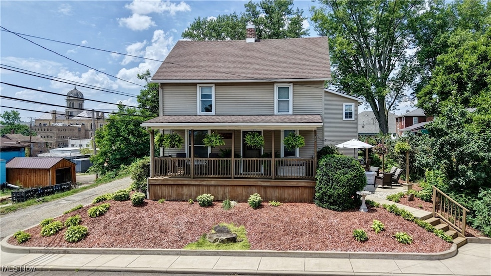
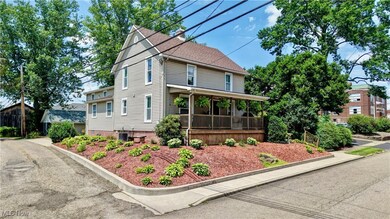
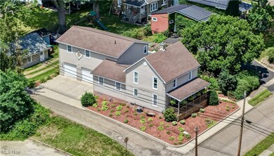
- Traditional Architecture
- 2 Car Attached Garage
- Wood Siding
- No HOA
- Forced Air Heating and Cooling System
About This Home
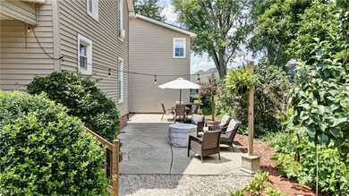
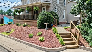
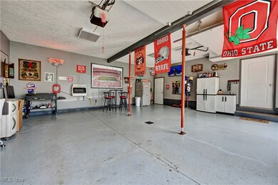
Excellent home that has been completely remodeled. Boasting 5 bedrooms and 2 1/2 bathrooms located in the heart of Carrollton, Ohio. Check out the update pages attached. The 30' x 24 +/- family room is a must see and welcomes the entertaining enthusiast. If you like entertaining, you'll love the full bar in the family room! 2 car garage with concrete floor and very spacious storage room built within garage. This home has a warm feeling of family and quietness of a country setting. A large patio area just outside for outdoor entertaining. Beautiful front porch that runs the width of the house for relaxing. Location is key and this home is situated perfectly. Many amenities can be found in the downtown and surrounding areas. Carrollton is home to brand new schools with excellent educational and extra-curricular opportunities.
Listing Agent
Willis Group Realty LLC Brokerage Email: 330-440-3253, jessewillisrealtor@gmail.com License #2024005145 Listed on: 07/11/2025
Home Details
Home Type
- Single Family
Est. Annual Taxes
- $1,757
Year Built
- Built in 1920 | Remodeled
Parking
- 2 Car Attached Garage
Home Design
- Traditional Architecture
- Fiberglass Roof
- Asphalt Roof
- Wood Siding
- Vinyl Siding
Interior Spaces
- 2,400 Sq Ft Home
- 2-Story Property
- Unfinished Basement
- Basement Fills Entire Space Under The House
Bedrooms and Bathrooms
- 5 Bedrooms | 1 Main Level Bedroom
Additional Features
- 4,792 Sq Ft Lot
- Forced Air Heating and Cooling System
Community Details
- No Home Owners Association
Listing and Financial Details
- Assessor Parcel Number 10-0001374000
Map
Create a Home Valuation Report for This Property
The Home Valuation Report is an in-depth analysis detailing your home's value as well as a comparison with similar homes in the area
Home Values in the Area
Average Home Value in this Area
Tax History
| Year | Tax Paid | Tax Assessment Tax Assessment Total Assessment is a certain percentage of the fair market value that is determined by local assessors to be the total taxable value of land and additions on the property. | Land | Improvement |
|---|---|---|---|---|
| 2024 | $1,759 | $50,260 | $4,280 | $45,980 |
| 2023 | $1,748 | $50,260 | $4,280 | $45,980 |
| 2022 | $1,737 | $41,710 | $3,550 | $38,160 |
| 2021 | $1,491 | $41,710 | $3,550 | $38,160 |
| 2020 | $1,419 | $41,710 | $3,550 | $38,160 |
| 2019 | $1,430 | $41,706 | $3,549 | $38,157 |
| 2018 | $1,119 | $31,320 | $2,320 | $29,000 |
| 2017 | $1,048 | $31,320 | $2,320 | $29,000 |
| 2016 | $971 | $28,730 | $2,130 | $26,600 |
| 2015 | $971 | $28,730 | $2,130 | $26,600 |
| 2014 | $971 | $28,730 | $2,130 | $26,600 |
| 2013 | $963 | $28,730 | $2,130 | $26,600 |
Source: Public Records
Property History
| Date | Event | Price | Change | Sq Ft Price |
|---|---|---|---|---|
| 08/05/2025 08/05/25 | Pending | -- | -- | -- |
| 08/02/2025 08/02/25 | Price Changed | $225,000 | -4.3% | $94 / Sq Ft |
| 07/11/2025 07/11/25 | For Sale | $235,000 | -- | $98 / Sq Ft |
Source: MLS Now
Purchase History
| Date | Type | Sale Price | Title Company |
|---|---|---|---|
| Interfamily Deed Transfer | -- | Beacon Title | |
| Quit Claim Deed | -- | Attorney | |
| Deed | -- | -- |
Source: Public Records
Mortgage History
| Date | Status | Loan Amount | Loan Type |
|---|---|---|---|
| Open | $121,286 | FHA | |
| Closed | $112,433 | FHA | |
| Closed | $81,961 | FHA |
Source: Public Records
Similar Homes in Carrollton, OH
Source: MLS Now
MLS Number: 5139278
APN: 10-0001374.000
Disclaimer: Certain information contained herein is derived from information provided by parties other than Homes.com. All information provided is deemed reliable, but is not guaranteed to be accurate and should be independently verified.
![]() IDX information is provided exclusively for personal, non-commercial use, and may not be used for any purpose other than to identify prospective properties consumers may be interested in purchasing. Information is deemed reliable but not guaranteed.
IDX information is provided exclusively for personal, non-commercial use, and may not be used for any purpose other than to identify prospective properties consumers may be interested in purchasing. Information is deemed reliable but not guaranteed.
Nearby Homes
- 67 2nd St NE Unit 22
- 345 E Main St Unit 3
- 208 2nd St SW Unit 5
- 238 High St SW Unit 3A
- 400 Park Ave NE
- 289 2nd St SW Unit 4A
- 5073 Salineville Rd NE
- 0 Moody Ave SW
- 755 Garfield Ave NW Unit 37
- 336 Steubenville Rd SE Unit 25K
- 551 6th St NW
- 810 Canton Rd NW Unit 75
- 615 Longhorn St NW Unit 20B
- 576 12th St NW
- 23 Penny Rd SW
- 1175 Lindy Ln NW
- 1238 Alamo Rd SE
- 2176 Pageant Rd SE
- 1219 Steubenville Rd SE Unit 24B
- 1368 Andora Rd NE