
Seller's Agent in 2019
Michele Flory
Point Real Estate
(713) 256-4998
19 in this area
96 Total Sales

Estimated Value: $1,035,000 - $1,244,000
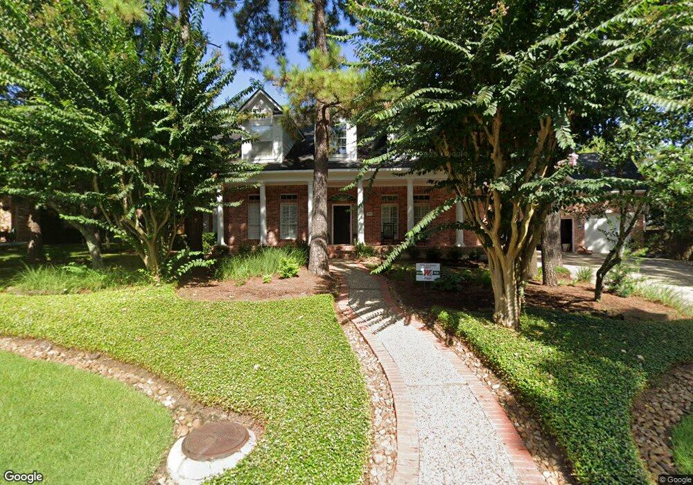
Traditional updated custom home on a near third acre lot in the highly sought after neighborhood of Taylor Point! Southern charm will greet your guest with the large front porch. Light naturally oiled white oak floor throughout the home are gorgeous & easy to maintain. Light walls brighten the home to maximize natural light. Kitchen with recently painted cabinets, appliances, Quartz counters & glass backsplash! Built-ins in the family room & study offer abundant storage. Master suite has views of the pool & back gardens! Master bath is beautiful with new fixtures, hardware & frameless enclosure. 3 bedrooms up, each with their own bath! Game room & huge bonus room up! Large pool in the backyard & still room to play! 3 car, side by side garage. So much has already been done for you...roof replaced in 2016, 3 a/c units replaced in 2012/2013, mosquito misting system, tankless HWH, generator! Walk to Bush Elementary, Alden Bridge park w/pool, courts, pond & more! 10 minutes to Town Center!
Last Agent to Sell the Property
Point Real Estate License #0473770 Listed on: 11/30/2018
Last Buyer's Agent
Missy Hynous
Terry A. Hynous License #0267801
| Date | Buyer | Sale Price | Title Company |
|---|---|---|---|
| Franck Ronald Jacob | -- | Old Republic Title | |
| Ulrichs Marcell | -- | Stewart Title Of Montgomery | |
| Lewis Bobby J | -- | -- | |
| Ulrichs Marcell | -- | -- |
| Date | Status | Borrower | Loan Amount |
|---|---|---|---|
| Open | Franck Ronald Jacob | $484,350 | |
| Previous Owner | Lewis Bobby J | $135,500 |
| Date | Event | Price | List to Sale | Price per Sq Ft |
|---|---|---|---|---|
| 12/30/2021 12/30/21 | Off Market | -- | -- | -- |
| 02/08/2019 02/08/19 | Sold | -- | -- | -- |
| 01/09/2019 01/09/19 | Pending | -- | -- | -- |
| 11/30/2018 11/30/18 | For Sale | $729,900 | -- | $163 / Sq Ft |
| Year | Tax Paid | Tax Assessment Tax Assessment Total Assessment is a certain percentage of the fair market value that is determined by local assessors to be the total taxable value of land and additions on the property. | Land | Improvement |
|---|---|---|---|---|
| 2025 | $14,354 | $952,664 | $140,000 | $812,664 |
| 2024 | $13,056 | $905,080 | -- | -- |
| 2023 | $13,056 | $822,800 | $140,000 | $760,000 |
| 2022 | $15,161 | $748,000 | $140,000 | $771,960 |
| 2021 | $16,021 | $734,530 | $50,370 | $684,160 |
| 2020 | $15,800 | $683,020 | $50,370 | $632,650 |
| 2019 | $17,267 | $723,480 | $50,370 | $673,110 |
| 2018 | $16,228 | $679,950 | $50,370 | $629,580 |
| 2017 | $16,428 | $679,950 | $50,370 | $629,580 |
| 2016 | $17,011 | $704,090 | $50,370 | $653,720 |
| 2015 | $14,760 | $676,500 | $50,370 | $675,740 |
| 2014 | $14,760 | $615,000 | $50,370 | $564,630 |
Seller's Agent in 2019
Michele Flory
Point Real Estate
(713) 256-4998
19 in this area
96 Total Sales
M
Buyer's Agent in 2019
Missy Hynous
Terry A. Hynous
Source: Houston Association of REALTORS®
MLS Number: 34820905
APN: 9719-13-08800
Disclaimer: Certain information contained herein is derived from information provided by parties other than Homes.com. All information provided is deemed reliable, but is not guaranteed to be accurate and should be independently verified.
![]() Copyright 2026, Houston REALTORS® Information Service, Inc.
Copyright 2026, Houston REALTORS® Information Service, Inc.
The information provided is exclusively for consumers’ personal, non-commercial use, and may not be used for any purpose other than to identify prospective properties consumers may be interested in purchasing.
Information is deemed reliable but not guaranteed.
Ask me questions while you tour the home.