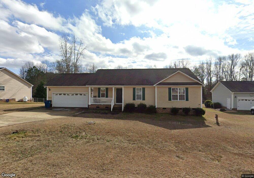
99 Tim Cir Angier, NC 27501
Pleasant Grove NeighborhoodEstimated Value: $284,000 - $307,327
3
Beds
2
Baths
1,339
Sq Ft
$221/Sq Ft
Est. Value
About This Home
This home is located at 99 Tim Cir, Angier, NC 27501 and is currently estimated at $295,832, approximately $220 per square foot. 99 Tim Cir is a home located in Johnston County with nearby schools including Benson Elementary School, Benson Middle School, and West Johnston High School.
Ownership History
Date
Name
Owned For
Owner Type
Purchase Details
Closed on
Jun 23, 2020
Sold by
Diaz Barraza Andres and Diaz Thelma Y
Bought by
Jaime Travis
Current Estimated Value
Home Financials for this Owner
Home Financials are based on the most recent Mortgage that was taken out on this home.
Original Mortgage
$194,949
Outstanding Balance
$172,807
Interest Rate
3.2%
Mortgage Type
New Conventional
Estimated Equity
$123,025
Purchase Details
Closed on
Sep 26, 2006
Sold by
Watkins Danny and Watkins Danny
Bought by
Ashley Turner Building Co Inc
Create a Home Valuation Report for This Property
The Home Valuation Report is an in-depth analysis detailing your home's value as well as a comparison with similar homes in the area
Home Values in the Area
Average Home Value in this Area
Purchase History
| Date | Buyer | Sale Price | Title Company |
|---|---|---|---|
| Jaime Travis | $193,000 | None Available | |
| Ashley Turner Building Co Inc | $120,000 | None Available |
Source: Public Records
Mortgage History
| Date | Status | Borrower | Loan Amount |
|---|---|---|---|
| Open | Jaime Travis | $194,949 |
Source: Public Records
Tax History
| Year | Tax Paid | Tax Assessment Tax Assessment Total Assessment is a certain percentage of the fair market value that is determined by local assessors to be the total taxable value of land and additions on the property. | Land | Improvement |
|---|---|---|---|---|
| 2025 | $1,981 | $312,020 | $65,000 | $247,020 |
| 2024 | $1,403 | $173,190 | $40,000 | $133,190 |
| 2023 | $1,351 | $173,190 | $40,000 | $133,190 |
| 2022 | $1,420 | $173,190 | $40,000 | $133,190 |
| 2021 | $1,386 | $173,190 | $40,000 | $133,190 |
| 2020 | $1,425 | $171,740 | $40,000 | $131,740 |
| 2019 | $1,425 | $171,740 | $40,000 | $131,740 |
| 2018 | $1,155 | $135,850 | $24,000 | $111,850 |
| 2017 | $1,155 | $135,850 | $24,000 | $111,850 |
| 2016 | $1,155 | $135,850 | $24,000 | $111,850 |
| 2015 | $1,155 | $135,850 | $24,000 | $111,850 |
| 2014 | $1,155 | $135,850 | $24,000 | $111,850 |
Source: Public Records
Map
Nearby Homes
- 81 Pinon Dr
- 50 Trail Ridge Dr
- 24 Sue Dr
- 0 Massengill Pond Rd
- 206 West Rd
- 285 Trail
- 18 Cedar Run Ct Unit 11
- 70 Alice Trace Place
- 95 Alice Trace Place
- 117 Alice Trace Place
- 102 Alice Trace Place
- 35 Evalice Ct
- 69 Andorra Place
- 133 Alice Trace Place
- 130 Alice Trace Place
- 57 Andorra Place
- 4194 Abattoir Rd
- 139 Bounty Cir
- 131 Regal Pond Dr
- 810 | 850 Wiggins Rd
Your Personal Tour Guide
Ask me questions while you tour the home.