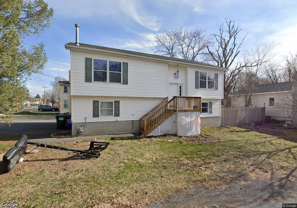
99 Univoice St Maybrook, NY 12543
Estimated Value: $321,000 - $379,000
3
Beds
2
Baths
1,038
Sq Ft
$345/Sq Ft
Est. Value
About This Home
This home is located at 99 Univoice St, Maybrook, NY 12543 and is currently estimated at $358,199, approximately $345 per square foot. 99 Univoice St is a home located in Orange County with nearby schools including Valley Central High School and Montgomery Montessori School.
Ownership History
Date
Name
Owned For
Owner Type
Purchase Details
Closed on
Aug 22, 2000
Sold by
Ambrosio Richard
Bought by
Cadiz Neida E
Current Estimated Value
Home Financials for this Owner
Home Financials are based on the most recent Mortgage that was taken out on this home.
Original Mortgage
$103,200
Interest Rate
7.8%
Mortgage Type
Balloon
Purchase Details
Closed on
May 5, 1998
Sold by
Brown Robert H and Brown Anna T
Bought by
Ambrosio Richard
Create a Home Valuation Report for This Property
The Home Valuation Report is an in-depth analysis detailing your home's value as well as a comparison with similar homes in the area
Home Values in the Area
Average Home Value in this Area
Purchase History
| Date | Buyer | Sale Price | Title Company |
|---|---|---|---|
| Cadiz Neida E | $129,000 | Fidelity National Title Ins | |
| Ambrosio Richard | $21,500 | -- |
Source: Public Records
Mortgage History
| Date | Status | Borrower | Loan Amount |
|---|---|---|---|
| Closed | Cadiz Neida E | $103,200 |
Source: Public Records
Tax History Compared to Growth
Tax History
| Year | Tax Paid | Tax Assessment Tax Assessment Total Assessment is a certain percentage of the fair market value that is determined by local assessors to be the total taxable value of land and additions on the property. | Land | Improvement |
|---|---|---|---|---|
| 2024 | $9,066 | $137,000 | $23,200 | $113,800 |
| 2023 | $9,066 | $137,000 | $23,200 | $113,800 |
| 2022 | $9,002 | $137,000 | $23,200 | $113,800 |
| 2021 | $8,886 | $137,000 | $23,200 | $113,800 |
| 2020 | $8,084 | $137,000 | $23,200 | $113,800 |
| 2019 | $7,582 | $137,000 | $23,200 | $113,800 |
| 2018 | $7,582 | $137,000 | $23,200 | $113,800 |
| 2017 | $7,310 | $137,000 | $23,200 | $113,800 |
| 2016 | $7,139 | $137,000 | $23,200 | $113,800 |
| 2015 | -- | $137,000 | $23,200 | $113,800 |
| 2014 | -- | $137,000 | $23,200 | $113,800 |
Source: Public Records
Map
Nearby Homes
- 313 Tower Ave
- 812 Tower Ave
- 711 Homestead Ave
- 311 Tower Ave
- 108 Homestead Ave
- 119 Clark Place
- 0 Homestead Ave Unit ONEH6328393
- 109 Indian Trail
- 111 Indian Trail
- 325 Rakov Rd
- 217 Blake Rd
- 108 Chrystal Dr
- 16 Palmer Ct
- 945 Homestead Ave
- 205 Everett Place
- 0 Neelytown Rd Unit KEYH6313123
- 3 Ted Miller Dr
- 2300 State Route 207
- 2323 State Route 207
- 611 Twin Arch Rd
- 704 Tower Ave
- 101 Univoice St
- 706 Tower Ave Unit A
- 706 Tower Ave
- 100 Univoice St
- 710 Tower Ave
- 610 Tower Ave
- 103 Univoice St
- 105 Univoice St Unit 1
- 701 Tower Ave
- 607 Tower Ave
- 712 Tower Ave
- 705 Tower Ave
- 708 Tower Ave
- 608 Tower Ave
- 102 Univoice St
- 102 Univoice St
- 707 Tower Ave
- 109 Univoice St
- 104 Univoice St