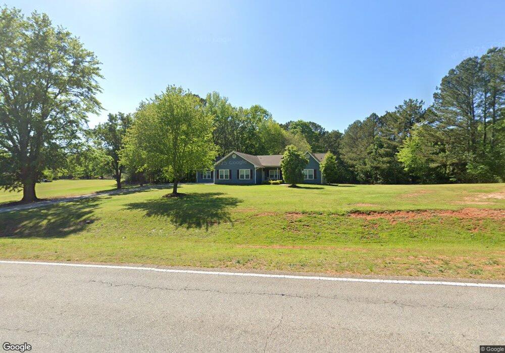
990 Simpson Mill Rd Locust Grove, GA 30248
Estimated Value: $324,000 - $369,000
3
Beds
3
Baths
2,487
Sq Ft
$138/Sq Ft
Est. Value
About This Home
This home is located at 990 Simpson Mill Rd, Locust Grove, GA 30248 and is currently estimated at $343,788, approximately $138 per square foot. 990 Simpson Mill Rd is a home located in Henry County with nearby schools including Luella Elementary School, Luella Middle School, and Luella High School.
Ownership History
Date
Name
Owned For
Owner Type
Purchase Details
Closed on
Apr 2, 2020
Sold by
Sims Michael L
Bought by
Sims Michael L and Sims Anna B
Current Estimated Value
Purchase Details
Closed on
Feb 24, 2020
Sold by
Sims Gregory M
Bought by
Sims Michael L
Purchase Details
Closed on
Jan 29, 2020
Sold by
Sims Kandy E Estate
Bought by
Sims Michael L and Sims Gregory M
Create a Home Valuation Report for This Property
The Home Valuation Report is an in-depth analysis detailing your home's value as well as a comparison with similar homes in the area
Home Values in the Area
Average Home Value in this Area
Purchase History
| Date | Buyer | Sale Price | Title Company |
|---|---|---|---|
| Sims Michael L | -- | -- | |
| Sims Michael L | -- | -- | |
| Sims Michael L | -- | -- |
Source: Public Records
Tax History Compared to Growth
Tax History
| Year | Tax Paid | Tax Assessment Tax Assessment Total Assessment is a certain percentage of the fair market value that is determined by local assessors to be the total taxable value of land and additions on the property. | Land | Improvement |
|---|---|---|---|---|
| 2025 | $3,650 | $139,120 | $16,600 | $122,520 |
| 2024 | $3,650 | $136,640 | $11,080 | $125,560 |
| 2023 | $3,430 | $132,400 | $10,640 | $121,760 |
| 2022 | $3,478 | $113,040 | $9,840 | $103,200 |
| 2021 | $2,927 | $89,760 | $8,440 | $81,320 |
| 2020 | $2,672 | $78,960 | $7,960 | $71,000 |
| 2019 | $2,542 | $73,440 | $7,560 | $65,880 |
| 2018 | $2,407 | $68,760 | $6,960 | $61,800 |
| 2016 | $2,143 | $61,880 | $6,160 | $55,720 |
| 2015 | $1,989 | $56,560 | $5,920 | $50,640 |
| 2014 | $1,975 | $55,720 | $5,920 | $49,800 |
Source: Public Records
Map
Nearby Homes
- 876 Simpson Mill Rd
- 201 Vandalay Way
- 163 Ashley Trace Dr Unit 1
- 170 Ashley Trace Dr
- 179 Ashley Trace Dr
- 121 Bradesbury Ln
- 718 Derek Place
- 1999 Hampton Locust Grove Rd
- 221 Ashley Trace Dr
- 231 Ashley Trace Dr
- 733 Derek Place Unit 2
- 871 Rocky Creek Rd
- 1871 Weems Rd
- 161 Donovan Ave
- 925 Reda Ct
- 320 Bianca Way
- 320 Bianca Way Unit 200
- 1665 Fuma Leaf Way Unit 244
- 1672 Fuma Leaf Way
- 1676 Fuma Leaf Way
- 1565 Hampton Locust Grove Rd
- 950 Simpson Mill Rd
- 1545 Hampton Locust Grove Rd
- 1664 Hampton Locust Grove Rd
- 975 Simpson Mill Rd
- 1644 Hampton Locust Grove Rd
- 1535 Hampton Locust Grove Rd
- 1604 Hampton Locust Grove Rd
- 596 Derek Place
- 1525 Hampton Locust Grove Rd
- 1584 Hampton Locust Grove Rd
- 595 Derek Place
- 1685 Hampton Locust Grove Rd
- 301 Vantage Point Unit 73
- 701 Trace Ct
- 100 Ashley Trace Dr
- 1515 Hampton Locust Grove Rd
- 110 Ashley Trace Dr
- 309 Vantage Point Unit 71
- 309 Vantage Point