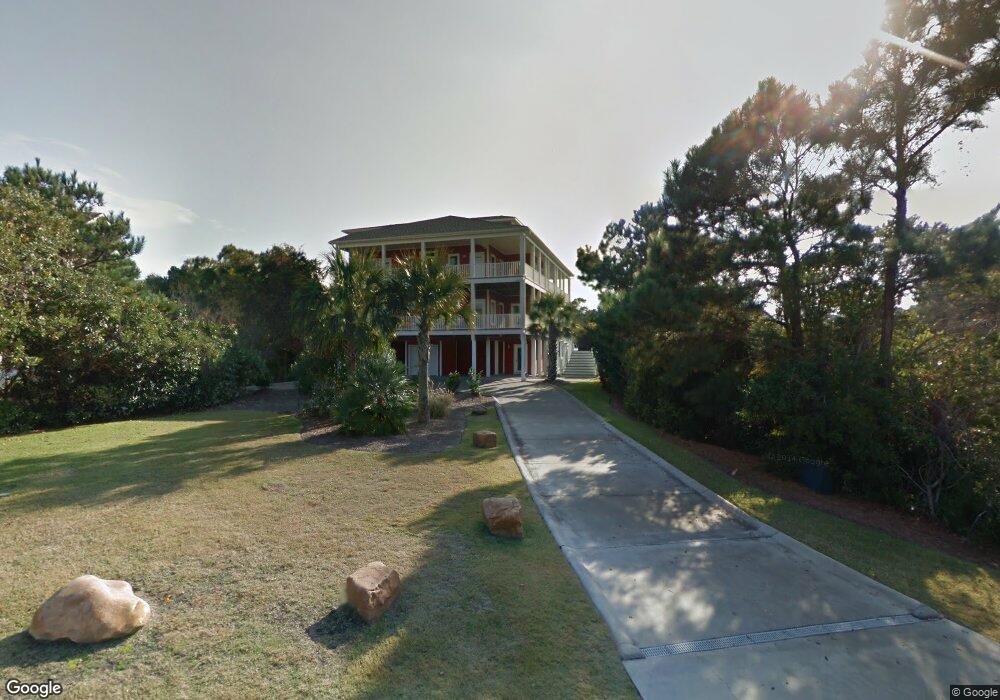
9907 Colonel Hanson Ct Emerald Isle, NC 28594
Estimated Value: $1,940,000 - $2,951,000
6
Beds
5
Baths
5,338
Sq Ft
$453/Sq Ft
Est. Value
About This Home
This home is located at 9907 Colonel Hanson Ct, Emerald Isle, NC 28594 and is currently estimated at $2,416,433, approximately $452 per square foot. 9907 Colonel Hanson Ct is a home with nearby schools including White Oak Elementary School, Broad Creek Middle School, and Croatan High School.
Ownership History
Date
Name
Owned For
Owner Type
Purchase Details
Closed on
Oct 18, 2024
Sold by
Sanborn Robert Curtis and Sanborn Lori B
Bought by
Morton Jodi D and Morton Darren C
Current Estimated Value
Purchase Details
Closed on
Oct 1, 2022
Sold by
Morton Darren C and Morton Jodi D
Bought by
Morton Darren C and Morton Jodi D
Purchase Details
Closed on
Aug 11, 2000
Purchase Details
Closed on
Sep 28, 1995
Create a Home Valuation Report for This Property
The Home Valuation Report is an in-depth analysis detailing your home's value as well as a comparison with similar homes in the area
Home Values in the Area
Average Home Value in this Area
Purchase History
| Date | Buyer | Sale Price | Title Company |
|---|---|---|---|
| Morton Jodi D | -- | None Listed On Document | |
| Morton Darren C | -- | -- | |
| Morton Darren C | -- | None Listed On Document | |
| -- | $79,500 | -- | |
| -- | $63,000 | -- |
Source: Public Records
Tax History Compared to Growth
Tax History
| Year | Tax Paid | Tax Assessment Tax Assessment Total Assessment is a certain percentage of the fair market value that is determined by local assessors to be the total taxable value of land and additions on the property. | Land | Improvement |
|---|---|---|---|---|
| 2025 | $5,283 | $1,469,761 | $361,958 | $1,107,803 |
| 2024 | $5,735 | $1,056,896 | $294,030 | $762,866 |
| 2023 | $5,413 | $1,010,503 | $294,030 | $716,473 |
| 2022 | $4,899 | $931,128 | $251,904 | $679,224 |
| 2021 | $4,796 | $931,128 | $251,904 | $679,224 |
| 2020 | $4,786 | $931,128 | $251,904 | $679,224 |
| 2019 | $2,804 | $899,714 | $182,630 | $717,084 |
| 2017 | $2,804 | $899,714 | $182,630 | $717,084 |
| 2016 | $2,804 | $899,714 | $182,630 | $717,084 |
| 2015 | $2,714 | $899,714 | $182,630 | $717,084 |
| 2014 | $3,026 | $1,003,630 | $194,478 | $809,152 |
Source: Public Records
Map
Nearby Homes
- 200 Shipwreck Ln
- 202 Shipwreck Ln
- 101 Windjammer
- 302 Friendship Ct
- 200 Windjammer E
- 9711 Dolphin Ridge Rd
- 9715 Poseidon Rd
- 302 Governor Safford Ln
- 9707 Poseidon Rd
- 9519 Ocean Dr Unit E & W
- 205 Albatross Ct
- 112 Page Place
- 107 Ocean Oaks Dr
- 200 Pelican Point Ct
- 109 Pinewood Place
- 9814 Clarendon Dr
- 9704 Ashley Place
- 10104 Seabreeze Dr
- 9706 Ashley Place
- 10002 Coast Guard Rd
- 9905 Colonel Hansen Ct
- 9905 Colonel Henson Ct
- 9904 Colonel Hansen Ct
- 205 Shipwreck Ln
- 203 Shipwreck Ln
- 9906 Crissie Wright Ct
- 9910 Crissie Wright Ct
- 9903 Colonel Hansen Ct
- 207 Shipwreck Ln
- 201 Shipwreck Ln
- 9904 Crissie Wright Ct
- 202 Aberlady Bay
- 9920 Shipwreck Ln Unit W
- 9920 Shipwreck Ln
- 209 Shipwreck Ln
- 9901 Colonel Hanson Ct
- 208 Shipwreck Ln
- 9911 Crissie Wright Ct Unit E
- 9911 Crissie Wright Ct Unit East
- 9911 Crissie Wright Ct