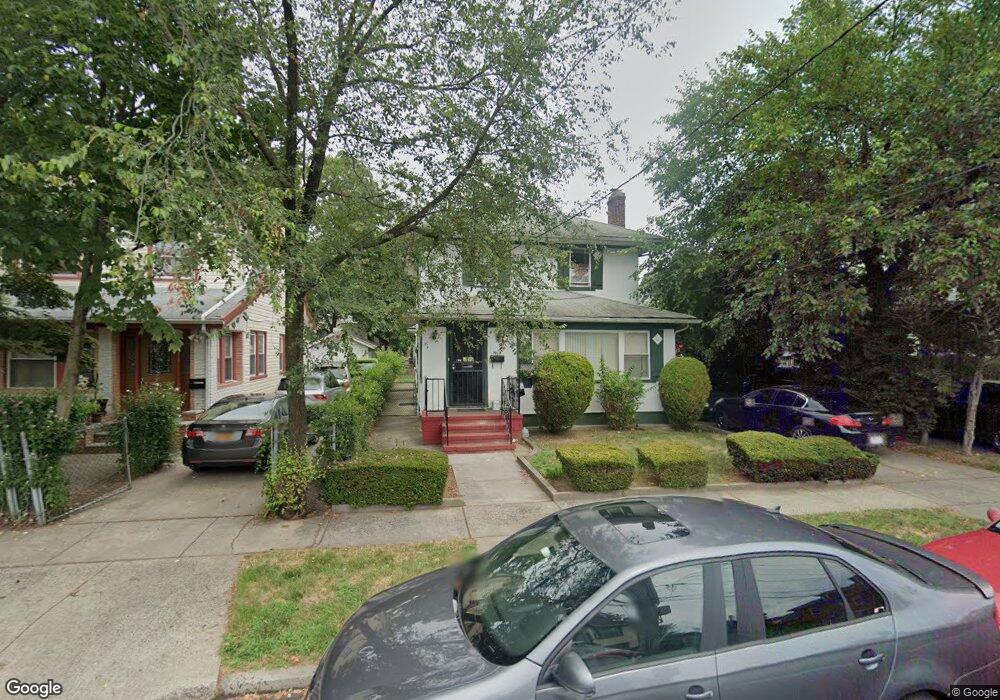
9917 195th St Hollis, NY 11423
Hollis NeighborhoodEstimated Value: $663,000 - $778,000
3
Beds
2
Baths
1,656
Sq Ft
$439/Sq Ft
Est. Value
About This Home
This home is located at 9917 195th St, Hollis, NY 11423 and is currently estimated at $727,683, approximately $439 per square foot. 9917 195th St is a home located in Queens County with nearby schools including P.S. 118 Lorraine Hansberry, I.S. 192 The Linden, and Wellspring Elementary & Middle.
Ownership History
Date
Name
Owned For
Owner Type
Purchase Details
Closed on
Jun 23, 2017
Sold by
Armstead Fred J and Monroe Sylvia E
Bought by
Kandasami Caroline
Current Estimated Value
Home Financials for this Owner
Home Financials are based on the most recent Mortgage that was taken out on this home.
Original Mortgage
$361,600
Outstanding Balance
$300,776
Interest Rate
4.02%
Mortgage Type
Purchase Money Mortgage
Estimated Equity
$426,907
Purchase Details
Closed on
Nov 1, 1990
Sold by
Mackey Martha A and Mackey William E
Bought by
Armstead Fred J and Monroe Sylvia E
Create a Home Valuation Report for This Property
The Home Valuation Report is an in-depth analysis detailing your home's value as well as a comparison with similar homes in the area
Home Values in the Area
Average Home Value in this Area
Purchase History
| Date | Buyer | Sale Price | Title Company |
|---|---|---|---|
| Kandasami Caroline | $452,000 | -- | |
| Armstead Fred J | -- | -- |
Source: Public Records
Mortgage History
| Date | Status | Borrower | Loan Amount |
|---|---|---|---|
| Open | Kandasami Caroline | $361,600 |
Source: Public Records
Tax History Compared to Growth
Tax History
| Year | Tax Paid | Tax Assessment Tax Assessment Total Assessment is a certain percentage of the fair market value that is determined by local assessors to be the total taxable value of land and additions on the property. | Land | Improvement |
|---|---|---|---|---|
| 2025 | $5,641 | $29,771 | $9,243 | $20,528 |
| 2024 | $5,641 | $28,088 | $10,107 | $17,981 |
| 2023 | $5,325 | $26,513 | $9,051 | $17,462 |
| 2022 | $5,293 | $38,880 | $14,400 | $24,480 |
| 2021 | $5,534 | $37,260 | $14,400 | $22,860 |
| 2020 | $5,249 | $32,040 | $14,400 | $17,640 |
| 2019 | $4,897 | $33,840 | $14,400 | $19,440 |
| 2018 | $4,504 | $22,094 | $10,438 | $11,656 |
| 2017 | $3,452 | $22,094 | $11,628 | $10,466 |
| 2016 | $3,330 | $22,094 | $11,628 | $10,466 |
| 2015 | $1,929 | $20,674 | $11,845 | $8,829 |
| 2014 | $1,929 | $19,506 | $12,519 | $6,987 |
Source: Public Records
Map
Nearby Homes
- 19611 100th Ave
- 197-21 Carpenter Ave Unit 1G
- 197-31 Carpenter Ave
- 9317 197th St
- 19515 Woodhull Ave
- 19511 Woodhull Ave
- 92-22 195th Place
- 19907 100th Ave
- 100-32 199th St
- 94-72 199th St
- 191-06 102nd Ave
- 99-11 200th St
- 194-10 Hollis Ave
- 190-30 103rd Ave
- 104-40 194th St
- 189-07 Henderson Ave
- 97-08 190th St
- 10445 198th St
- 10411 200th St
- 104-39 199th St