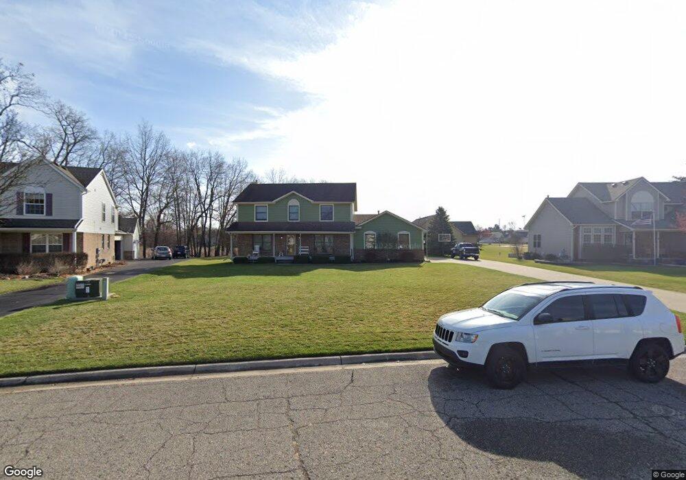
9931 Aylebury Dr South Lyon, MI 48178
Estimated Value: $480,448 - $532,000
4
Beds
3
Baths
2,170
Sq Ft
$236/Sq Ft
Est. Value
About This Home
This home is located at 9931 Aylebury Dr, South Lyon, MI 48178 and is currently estimated at $512,612, approximately $236 per square foot. 9931 Aylebury Dr is a home located in Livingston County with nearby schools including William A. Brummer Elementary School, Centennial Middle School, and South Lyon High School.
Ownership History
Date
Name
Owned For
Owner Type
Purchase Details
Closed on
May 26, 2005
Sold by
Zurawski Kenneth J and Zurawski Karen A
Bought by
Habkirk Gary M and Habkirk Dawn L
Current Estimated Value
Home Financials for this Owner
Home Financials are based on the most recent Mortgage that was taken out on this home.
Original Mortgage
$228,000
Outstanding Balance
$119,489
Interest Rate
5.82%
Mortgage Type
Fannie Mae Freddie Mac
Estimated Equity
$393,123
Create a Home Valuation Report for This Property
The Home Valuation Report is an in-depth analysis detailing your home's value as well as a comparison with similar homes in the area
Home Values in the Area
Average Home Value in this Area
Purchase History
| Date | Buyer | Sale Price | Title Company |
|---|---|---|---|
| Habkirk Gary M | $285,000 | -- |
Source: Public Records
Mortgage History
| Date | Status | Borrower | Loan Amount |
|---|---|---|---|
| Open | Habkirk Gary M | $228,000 | |
| Closed | Habkirk Gary M | $28,500 |
Source: Public Records
Tax History Compared to Growth
Tax History
| Year | Tax Paid | Tax Assessment Tax Assessment Total Assessment is a certain percentage of the fair market value that is determined by local assessors to be the total taxable value of land and additions on the property. | Land | Improvement |
|---|---|---|---|---|
| 2025 | $4,336 | $220,200 | $0 | $0 |
| 2024 | $2,901 | $197,000 | $0 | $0 |
| 2023 | $2,767 | $186,500 | $0 | $0 |
| 2022 | $3,532 | $142,300 | $0 | $0 |
| 2021 | $3,532 | $159,400 | $0 | $0 |
| 2020 | $3,515 | $157,300 | $0 | $0 |
| 2019 | $3,549 | $142,300 | $0 | $0 |
| 2018 | $3,510 | $131,900 | $0 | $0 |
| 2017 | $3,556 | $131,300 | $0 | $0 |
| 2016 | $3,607 | $130,900 | $0 | $0 |
| 2014 | $3,271 | $112,500 | $0 | $0 |
| 2012 | $3,271 | $111,400 | $0 | $0 |
Source: Public Records
Map
Nearby Homes
- 9859 Aylebury Dr
- 13428 Sequoia Ln
- Bradford Plan at Charleston Park
- Bradford with Second Floor Plan at Charleston Park
- Bartelle Plan at Charleston Park
- Upton Plan at Charleston Park
- Westford Plan at Charleston Park
- Addison Plan at Charleston Park
- Madison Plan at Charleston Park
- Nantucket Plan at Charleston Park
- Preston Plan at Charleston Park
- Rockport II Plan at Charleston Park
- Remington Plan at Charleston Park
- 667 Allegheny Dr
- 174 Singh Blvd
- 13802 Forest Ridge Cir
- 577 W Lake St
- 671 E Crest Ln
- 702 Westhills Dr
- 359 Amelia Cir
- 9949 Aylebury Dr
- 13711 Windmoor Dr
- 9913 Aylebury Dr
- 13687 Windmoor Dr
- 13719 Windmoor Dr
- 9904 Aylebury Dr
- 9895 Aylebury Dr
- 13704 Windmoor Dr
- 13679 Windmoor Dr
- 13712 Windmoor Dr
- 13727 Windmoor Dr
- 13720 Windmoor Dr
- 13667 Windmoor Dr
- 9988 Aylebury Dr
- 13659 Windmoor Dr
- 9877 Aylebury Dr
- 13728 Windmoor Dr
- 13614 Huntley Ct
- 13632 Huntley Ct
- 13735 Windmoor Dr