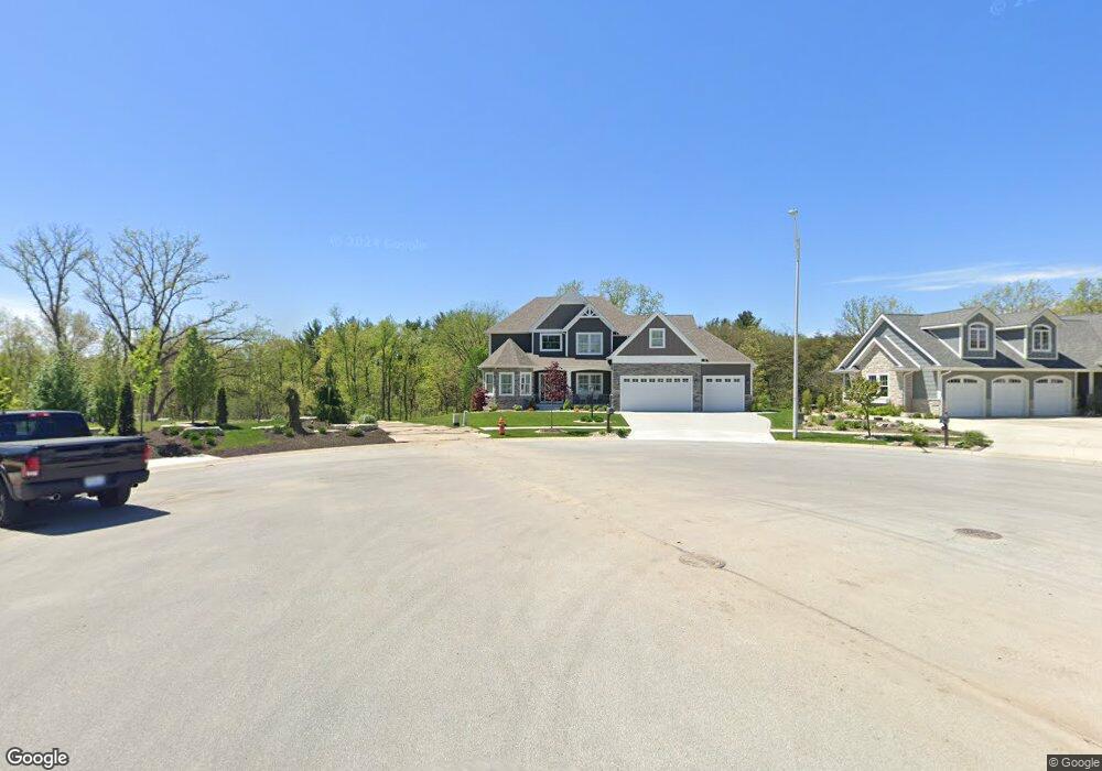
996 Sylvia Ln Crown Point, IN 46307
Estimated Value: $757,000 - $822,412
4
Beds
3
Baths
2,982
Sq Ft
$266/Sq Ft
Est. Value
About This Home
This home is located at 996 Sylvia Ln, Crown Point, IN 46307 and is currently estimated at $793,853, approximately $266 per square foot. 996 Sylvia Ln is a home with nearby schools including Lake Street Elementary School, Robert Taft Middle School, and Crown Point High School.
Ownership History
Date
Name
Owned For
Owner Type
Purchase Details
Closed on
Sep 25, 2020
Sold by
Brouwer John W and Brouwer John W
Bought by
Brouwer John W
Current Estimated Value
Home Financials for this Owner
Home Financials are based on the most recent Mortgage that was taken out on this home.
Original Mortgage
$585,000
Outstanding Balance
$523,572
Interest Rate
3.25%
Mortgage Type
Construction
Estimated Equity
$270,281
Purchase Details
Closed on
May 28, 2020
Sold by
Mcfs Development Llc
Bought by
John W Brouwer Revocable Living Trust
Create a Home Valuation Report for This Property
The Home Valuation Report is an in-depth analysis detailing your home's value as well as a comparison with similar homes in the area
Home Values in the Area
Average Home Value in this Area
Purchase History
| Date | Buyer | Sale Price | Title Company |
|---|---|---|---|
| Brouwer John W | -- | Fidelity National Title Co | |
| John W Brouwer Revocable Living Trust | -- | None Available |
Source: Public Records
Mortgage History
| Date | Status | Borrower | Loan Amount |
|---|---|---|---|
| Open | Brouwer John W | $585,000 |
Source: Public Records
Tax History Compared to Growth
Tax History
| Year | Tax Paid | Tax Assessment Tax Assessment Total Assessment is a certain percentage of the fair market value that is determined by local assessors to be the total taxable value of land and additions on the property. | Land | Improvement |
|---|---|---|---|---|
| 2024 | $20,915 | $828,000 | $132,100 | $695,900 |
| 2023 | $8,516 | $761,000 | $132,100 | $628,900 |
| 2022 | $7,858 | $696,400 | $124,700 | $571,700 |
| 2021 | $7,675 | $680,800 | $114,000 | $566,800 |
| 2020 | $29 | $1,200 | $1,200 | $0 |
| 2019 | $29 | $1,200 | $1,200 | $0 |
| 2018 | $31 | $1,200 | $1,200 | $0 |
| 2017 | $31 | $1,200 | $1,200 | $0 |
Source: Public Records
Map
Nearby Homes
- 3721 W 133rd Ave
- 12715 Cedar Lake Rd
- 12812 Whitcomb St
- 4422 W 133rd Ave
- 12201 Cedar Lake Rd
- 12860 Baker Ct
- 1575 S Feather Rock Dr
- 12768 Ellsworth Place
- The Cottonwood Plan at Golden Meadow
- The Magnolia Plan at Golden Meadow
- The Birch Plan at Golden Meadow
- 1540 Brackenbury Ln
- The Willow Plan at Golden Meadow
- 2725 W 127th Ln
- 2800 W 133rd Ave
- 11498 Hancock Dr
- 283 Nomo Place
- 253 Nomo Place
- The Ganby Plan at Sawgrass
- The Monarch Plan at Sawgrass