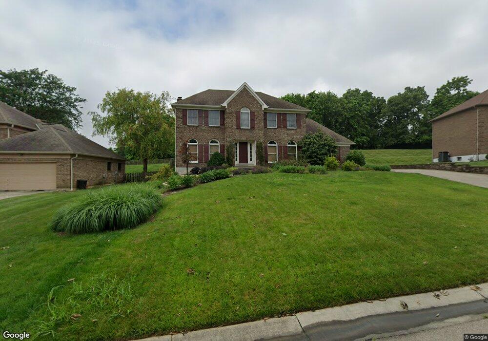
9999 Bolingbroke Dr Cincinnati, OH 45241
West Chester Township NeighborhoodEstimated Value: $508,683 - $553,000
4
Beds
3
Baths
2,776
Sq Ft
$194/Sq Ft
Est. Value
About This Home
This home is located at 9999 Bolingbroke Dr, Cincinnati, OH 45241 and is currently estimated at $538,421, approximately $193 per square foot. 9999 Bolingbroke Dr is a home located in Butler County with nearby schools including Adena Elementary School, Lakota Ridge Junior School, and Lakota West High School.
Ownership History
Date
Name
Owned For
Owner Type
Purchase Details
Closed on
Apr 13, 2000
Sold by
Schmidt Raymond I and Schmidt Deborah G
Bought by
Zajac John A and Zajac Laura L
Current Estimated Value
Home Financials for this Owner
Home Financials are based on the most recent Mortgage that was taken out on this home.
Original Mortgage
$148,250
Interest Rate
8.18%
Mortgage Type
Purchase Money Mortgage
Purchase Details
Closed on
Feb 1, 1988
Create a Home Valuation Report for This Property
The Home Valuation Report is an in-depth analysis detailing your home's value as well as a comparison with similar homes in the area
Home Values in the Area
Average Home Value in this Area
Purchase History
| Date | Buyer | Sale Price | Title Company |
|---|---|---|---|
| Zajac John A | $242,000 | -- | |
| -- | $170,000 | -- |
Source: Public Records
Mortgage History
| Date | Status | Borrower | Loan Amount |
|---|---|---|---|
| Previous Owner | Zajac John A | $148,250 |
Source: Public Records
Tax History Compared to Growth
Tax History
| Year | Tax Paid | Tax Assessment Tax Assessment Total Assessment is a certain percentage of the fair market value that is determined by local assessors to be the total taxable value of land and additions on the property. | Land | Improvement |
|---|---|---|---|---|
| 2024 | $6,461 | $153,160 | $20,040 | $133,120 |
| 2023 | $6,412 | $153,400 | $20,040 | $133,360 |
| 2022 | $5,828 | $102,370 | $20,040 | $82,330 |
| 2021 | $5,319 | $98,450 | $20,040 | $78,410 |
| 2020 | $5,440 | $98,450 | $20,040 | $78,410 |
| 2019 | $4,860 | $85,170 | $19,460 | $65,710 |
| 2018 | $4,947 | $85,170 | $19,460 | $65,710 |
| 2017 | $5,030 | $85,170 | $19,460 | $65,710 |
| 2016 | $4,869 | $77,620 | $19,460 | $58,160 |
| 2015 | $4,745 | $77,620 | $19,460 | $58,160 |
| 2014 | $5,107 | $76,800 | $19,460 | $57,340 |
| 2013 | $5,107 | $79,450 | $19,460 | $59,990 |
Source: Public Records
Map
Nearby Homes
- 9843 Tall Timber Dr
- 12160 Village Woods Dr
- 7089 Windwood Dr
- 5434 Oliver Ct
- 12108 Village Woods Dr
- 5172 Londonderry Dr
- 9712 Lupine Dr
- 12080 Thames Place
- 5375 Dickens Dr
- 9750 Cincinnati Columbus Rd
- 11960 Big Ben Ct
- 5725 Sovereign Dr
- 7327 Dimmick Rd
- 9647 Friar Tuck Dr
- 5026 Lord Alfred Ct
- 11794 Tennyson Dr
- 6779 Windwood Dr
- 9447 Eastbrook Dr
- 9616 Holly Leaf Cir
- 5600 E Kemper Rd
- 10005 Bolingbroke Dr
- 9995 Bolingbroke Dr
- 10011 Bolingbroke Dr
- 9994 Bolingbroke Dr
- 9991 Bolingbroke Dr
- 10002 Bolingbroke Dr
- 7406 Rodney Ct
- 7412 Rodney Ct
- 10008 Bolingbroke Dr
- 7381 Kelly Ct
- 10017 Bolingbroke Dr
- 9986 Bolingbroke Dr
- 10014 Bolingbroke Dr
- 10012 Sonya Ln
- 9987 Bolingbroke Dr
- 7375 Kelly Ct
- 7376 Kelly Ct
- 7422 Rodney Ct
- 10001 Sonya Ln
- 10020 Bolingbroke Dr