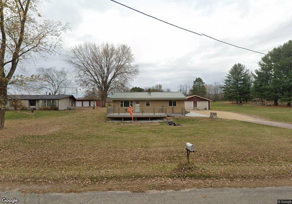
E11988 Side Rd Baraboo, WI 53913
Estimated Value: $259,000 - $433,000
4
Beds
2
Baths
1,409
Sq Ft
$239/Sq Ft
Est. Value
About This Home
This home is located at E11988 Side Rd, Baraboo, WI 53913 and is currently estimated at $336,367, approximately $238 per square foot. E11988 Side Rd is a home located in Sauk County with nearby schools including Baraboo High School, Community Christian School of Baraboo, and Community Christian School.
Ownership History
Date
Name
Owned For
Owner Type
Purchase Details
Closed on
Sep 13, 2014
Sold by
Luther Thomas F
Bought by
Luther Thomas F
Current Estimated Value
Purchase Details
Closed on
Jun 2, 2008
Sold by
Miotke Barbara L
Bought by
Luther Thomas F
Home Financials for this Owner
Home Financials are based on the most recent Mortgage that was taken out on this home.
Original Mortgage
$166,250
Interest Rate
6.09%
Mortgage Type
Future Advance Clause Open End Mortgage
Create a Home Valuation Report for This Property
The Home Valuation Report is an in-depth analysis detailing your home's value as well as a comparison with similar homes in the area
Purchase History
| Date | Buyer | Sale Price | Title Company |
|---|---|---|---|
| Luther Thomas F | $16,380,000 | -- | |
| Luther Thomas F | $175,000 | -- |
Source: Public Records
Mortgage History
| Date | Status | Borrower | Loan Amount |
|---|---|---|---|
| Previous Owner | Luther Thomas F | $166,250 |
Source: Public Records
Tax History
| Year | Tax Paid | Tax Assessment Tax Assessment Total Assessment is a certain percentage of the fair market value that is determined by local assessors to be the total taxable value of land and additions on the property. | Land | Improvement |
|---|---|---|---|---|
| 2024 | $28 | $163,800 | $36,000 | $127,800 |
| 2023 | $2,721 | $163,800 | $36,000 | $127,800 |
| 2022 | $2,768 | $163,800 | $36,000 | $127,800 |
| 2021 | $2,807 | $163,800 | $36,000 | $127,800 |
| 2020 | $2,617 | $163,800 | $36,000 | $127,800 |
| 2019 | $2,641 | $163,800 | $36,000 | $127,800 |
| 2018 | $2,593 | $163,800 | $36,000 | $127,800 |
| 2017 | $2,557 | $163,800 | $36,000 | $127,800 |
| 2016 | $2,506 | $163,800 | $36,000 | $127,800 |
| 2015 | $2,463 | $163,800 | $36,000 | $127,800 |
| 2014 | $2,427 | $163,800 | $36,000 | $127,800 |
Source: Public Records
Map
Nearby Homes
- E11616 N Reedsburg Rd
- S4067 County Hwy A
- S4168 Crawford St
- S4121 Crawford St
- S4166 Crawford St
- 59.04 County Rd W
- 1505 Manassas Dr Unit 50
- 1500 15th St
- 128 Monroe St
- S4362 Fox Hill Cir
- 80.68 Acres Fox Hill Rd
- 1130 12th St Unit 1132
- 1116 12th St
- 1735 Crawford St Unit 8
- Lot 1 CSM 1231 Jefferson St
- 727 11th St
- E11220 Birnam Woods Rd
- 409 11th St
- 435 14th Ave
- S4166 Whispering Pines Dr
- E11974 Side Rd
- E12004 Side Rd
- E12026 Side Rd
- E11940 Side Rd
- E11936 Side Rd
- E12055 Twin Oaks Rd
- E12032 Side Rd
- S3543 Pine Knoll Ct
- S3535 Pine Knoll Ct
- E12044 Side Rd
- 34.69 ac Side Rd
- S3557 Pine Knoll Ct
- S3565 Pine Knoll Ct
- S3528 Pine Knoll Ct
- S3573 Pine Knoll Ct
- Lot 81 Pine Knoll Ct
- E12054 Twin Oaks Rd
- E12056 Twin Oaks Rd
- E11904 Side Rd
- S3578 Pine Knoll Ct
Your Personal Tour Guide
Ask me questions while you tour the home.