

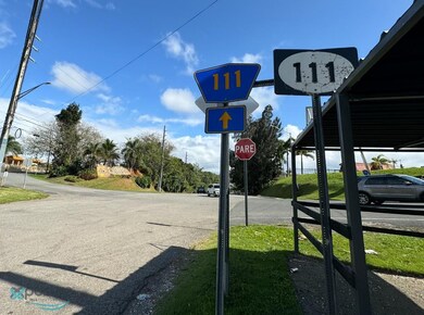

KM 32.0 Carretera Pr 111 Lares Unit KM 32.0 Lares, PR 00657
Estimated payment $12,562/month
Total Views
1,281
6.97
Acres
$287,054
Price per Acre
303,497
Sq Ft Lot
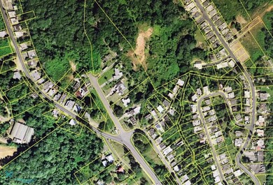
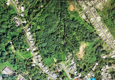
About This Lot
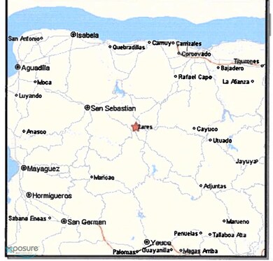
Undeveloped Parcel of land in Lares, Puerto Rico. North of Road PR-111, Km. 32.0 Adjacent to Jardines de Lares Urbanization. Flood Classification Zone "C" (Outside of Flood Hazard Area) Zoning Complying with Commercial (C-2) Parameters. The municipality of Lares is located on the central mountain region of Puerto Rico, about 64 miles from San Juan. From Arecibo to the subject area, access is through Road PR-129 southbound until reaching Road PR-111. Driving time from San Juan to the subject property is approximately 90 minutes..
Property Details
Property Type
- Land
Additional Features
- 6.97 Acre Lot
- Property is near shops
Map
Create a Home Valuation Report for This Property
The Home Valuation Report is an in-depth analysis detailing your home's value as well as a comparison with similar homes in the area
Home Values in the Area
Average Home Value in this Area
Property History
| Date | Event | Price | List to Sale | Price per Sq Ft |
|---|---|---|---|---|
| 06/09/2025 06/09/25 | Off Market | $2,000,000 | -- | -- |
| 04/02/2025 04/02/25 | Off Market | $2,000,000 | -- | -- |
| 12/29/2024 12/29/24 | For Sale | $2,000,000 | 0.0% | -- |
| 12/28/2024 12/28/24 | For Sale | $2,000,000 | 0.0% | -- |
| 09/02/2024 09/02/24 | Off Market | $2,000,000 | -- | -- |
| 03/10/2024 03/10/24 | For Sale | $2,000,000 | -- | -- |
Source: Xposure MLS Puerto Rico
Source: Xposure MLS Puerto Rico
MLS Number: 54281
Nearby Homes
- 0 Pr129 Km 2
- KM 33.3 Carr 129
- 128 Lares Unit 43.3
- #111 Bo Lares Sector Palmar Llano
- 111RD Bo Pueblo Km 2 61 Lares Pr 00669
- 1 1 Bo Angeles El Corcho
- CARR 431 Carr 431 La Gloria
- 0 Lares Bo Pueblo Unit 62295
- Carrt 602 Sector El Corcho Angeles
- 94 Albizu Campos
- 111 Carr 111
- Carr 129 Km Hm 11 0
- 0 Bo La Torre
- 50 Calle Central
- 010 Camino Patria Rullán
- Ramal 602 Bo Angeles Sector El Poblado Unit Carr 111
- 0
- 43 Bo Santa Isabel Camino Patria Rullán
- 602 Carretera Poblado
- 602 Poblado Angeles
- Carr 129
- 1 Pr 455 Km 0 9 Unit 1
- KM 95.5 int Yeguada Ward Rd 2
- Km 13.6 Carr 476 Unit Arriba
- calle 2 110 Carr 3 Km 348 Urb Ocean Blue
- 0 Carr 457 Bo Planas 0 2 Unit 2
- Estancias Palmas del Palma Gorda
- Carr. 497, Km.1.6 Bo Pozas
- 0 Calle Horizonte Unit 515B
- 1 La Sabana Unit Lot 1
- 492 Calle A Unit 6
- I Calle 4 # A Unit Urb Hacienda del Par
- 4 I
- D Carolina Condominio Polaris Unit 508
- 82 Calle Caracol Unit 82 Caracol
- Carr. 495, Km. 1.4 Bo Cerro Gordo Sector Medina
- 0 Comunidad Tavarez
- . Pr 112 Arenales Isabela Prairie
- 474 Calle Manzano
- PR368 INT Pr368 Int Unit Lot A3
