


LOT 24 Trail Ridge Rd Alpine, WY 83128
Estimated payment $1,694/month
Total Views
8,827
2.66
Acres
$109,023
Price per Acre
115,870
Sq Ft Lot
Highlights
- Scenic Views
- Wooded Lot
- Adjoins Government Land
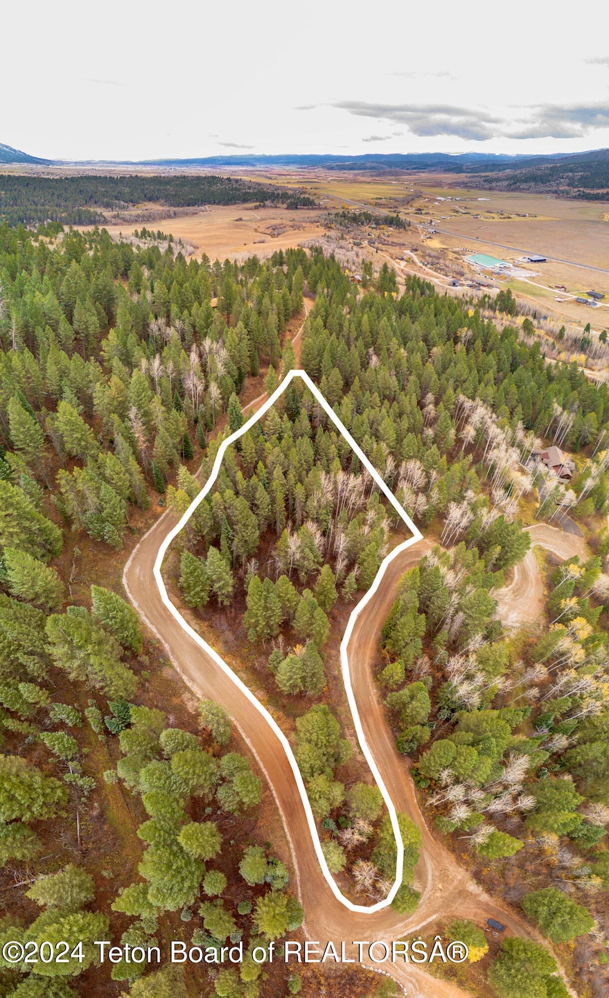
About This Lot
Beautifully treed and elevated lot just south of Alpine in the esteemed Shadow Dancer Estates subdivision. Excellent mountain views to the west and filtered views of the Palisades. The perfect setting to build your dream mountain home. The lot is serviced by a community water system including a fire hydrant network throughout the neighborhood, piped-in propane gas, and fiber optic cable & internet. This lot offers easy access for outdoor recreation via the bordering Game & Fish land. Only 45 minutes from Jackson Hole.
Property Details
Property Type
- Land
Est. Annual Taxes
- $1,275
Lot Details
- 2.66 Acre Lot
- Adjoins Government Land
- Year Round Access
- Wooded Lot
- Landscaped with Trees
Property Views
- Scenic Vista
- Mountain
- Valley
Utilities
- Electricity To Lot Line
- Private Water Source
- Fiber Optics Available
Community Details
- Property has a Home Owners Association
- Shadow Dancer Subdivision
Listing and Financial Details
- Tax Lot 24
- Assessor Parcel Number 36191040048200
Map
Create a Home Valuation Report for This Property
The Home Valuation Report is an in-depth analysis detailing your home's value as well as a comparison with similar homes in the area
Home Values in the Area
Average Home Value in this Area
Tax History
| Year | Tax Paid | Tax Assessment Tax Assessment Total Assessment is a certain percentage of the fair market value that is determined by local assessors to be the total taxable value of land and additions on the property. | Land | Improvement |
|---|---|---|---|---|
| 2025 | $1,275 | $26,565 | $26,565 | $0 |
| 2024 | $1,275 | $20,451 | $20,451 | $0 |
| 2023 | $1,274 | $20,451 | $20,451 | $0 |
| 2022 | $1,062 | $17,043 | $17,043 | $0 |
| 2021 | $656 | $10,503 | $10,503 | $0 |
| 2020 | $571 | $9,133 | $9,133 | $0 |
| 2019 | $571 | $9,133 | $9,133 | $0 |
| 2018 | $570 | $9,133 | $9,133 | $0 |
| 2017 | $569 | $9,133 | $9,133 | $0 |
| 2016 | -- | $7,306 | $7,306 | $0 |
| 2015 | -- | $7,306 | $7,306 | $0 |
| 2014 | -- | $7,306 | $7,306 | $0 |
Source: Public Records
Property History
| Date | Event | Price | Change | Sq Ft Price |
|---|---|---|---|---|
| 04/29/2025 04/29/25 | Price Changed | $290,000 | -7.9% | -- |
| 11/04/2024 11/04/24 | For Sale | $315,000 | +17.1% | -- |
| 07/08/2021 07/08/21 | Sold | -- | -- | -- |
| 06/17/2021 06/17/21 | Pending | -- | -- | -- |
| 05/23/2021 05/23/21 | For Sale | $269,000 | -- | -- |
Source: Teton Board of REALTORS®
Source: Teton Board of REALTORS®
MLS Number: 24-2733
APN: 36191040048200
Nearby Homes
- 374 Upper Ridge Rd
- 57 Lynx Trail
- 660 Buffalo Dr
- 39 Trail Ridge Rd
- 22 Trail Ridge Rd
- 604 Falcon Dr
- TBD Lot 21 River Trail Dr
- 1 Buffalo Dr
- 8.60 ACRES McNeel Power Plant Rd
- LOT 31 River Trail Dr
- 22 River Trail Dr
- 227 McNeal Power Plant Rd
- LOTS 1 & 2 Lever Springs Rd
- 800 Dell Creek
- 23 Fox Trail Dr
- LOT 2 Kibbie Pkwy
- 616 McNeel Rd
- 92 Ashley Dr
- 278 Dell Creek Rd
- L22 Caribou Forest Dr
