Estimated payment $987/month
Highlights
- Partially Wooded Lot
- Pasture
- Partially Fenced Property
- Corner Lot
- Agricultural
- Level Lot
About This Lot
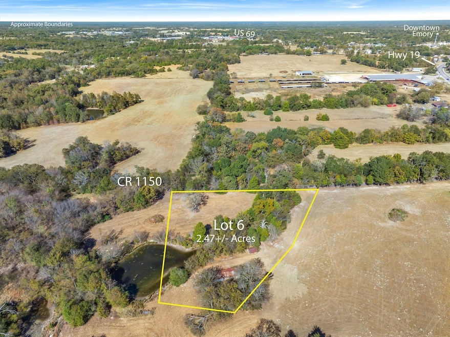
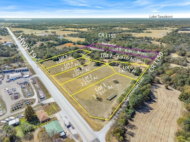
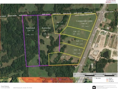
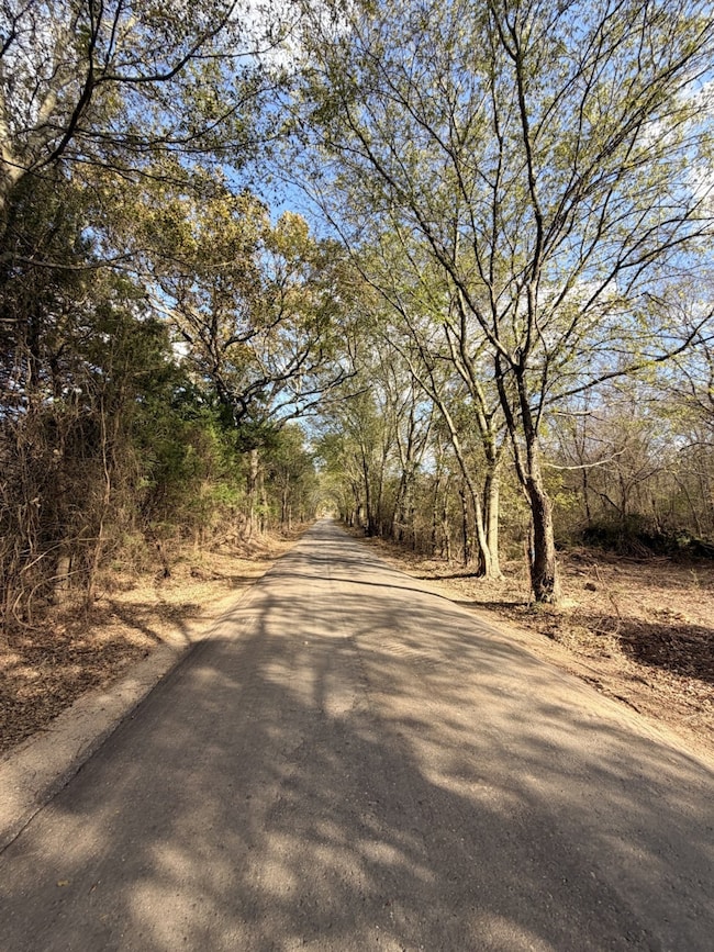
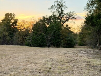
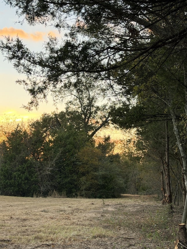
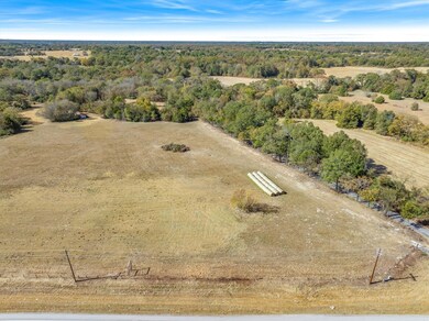
PRIME 2.47± ACRE COMMERCIAL LOT IN EMORY, TEXAS! Exceptional commercial opportunity, for almost 2.5 acres down a tree-lined County Road, that adjoins Commercial Corner Lot #1 and-or Lot # 2 with great visibilty on State Highway 19 - located inside the expanding Emory city limits. This 2.47± acre tract (Commercial LOT#6) offers more than 380' of frontage on RS County Road 1150, providing outstanding exposure and easy access for a wide range of commercial uses. Recently zoned Commercial, but could easliy be zoned residential as well....with city & county utilities & services nearby, the property sits just over one mile from downtown Emory, just off SH -19. The location offers immediate development potential or long-term investment value in a market known for strong community pride and a welcoming small-town feel. Emory continues to grow, supported by its position between Lake Fork & Lake Tawakoni and its proximity to the DFW Metroplex and Tyler—driving demand in tourism, retail, and local services. Addt'l. ADJOINING Commercial Lots &-or Residential Lots are available. Seller is open to flexible subdivision or combinations of lots to accommodate buyer requirements, making this site well suitable for retail, local services, hospitality, or mixed-use development. The land has clearings, beautiful woods & a slight roll, with sandy soil & this this lot has no flood plan. This exceptional location offers easy access from SH 19. This lot, has an old pole barn building & shed (assigned no value) from the days of the Emory Archer Club, & overlooks the neighboring Residential Lot # 7's serene pond. Seller financing is available & with various lot options offered from 2-6.9 acres (which can be combined) - options to suit your business need are endless. If you are considering one of the adjoining Resdential Lots (Lot # 7 or 7 & 8 combined) this Lot could provide additional acreage, if desired. All lots contracted will be platted prior to Closing. More info needed? Contact Agent
Listing Agent
RE/MAX Landmark Brokerage Phone: 972-524-0689 License #0621134 Listed on: 11/18/2025

Property Details
Property Type
- Land
Est. Annual Taxes
- $106
Lot Details
- 2.47 Acre Lot
- Property fronts a highway
- Partially Fenced Property
- Barbed Wire
- Corner Lot
- Level Lot
- Irregular Lot
- Cleared Lot
- Partially Wooded Lot
- Many Trees
- 6 Lots in the community
- Zoning described as Recently Zoned COMMERCIAL
Location
- City Lot
Schools
- Rains Elementary School
- Rains High School
Farming
- Agricultural
- Pasture
Utilities
- Overhead Utilities
- Sewer Not Available
Listing and Financial Details
- Tax Lot 6
- Assessor Parcel Number R1718
Map
Home Values in the Area
Average Home Value in this Area
Tax History
| Year | Tax Paid | Tax Assessment Tax Assessment Total Assessment is a certain percentage of the fair market value that is determined by local assessors to be the total taxable value of land and additions on the property. | Land | Improvement |
|---|---|---|---|---|
| 2024 | $8,426 | $482,095 | $480,194 | $1,901 |
| 2023 | $8,426 | $482,095 | $480,194 | $1,901 |
| 2022 | $8,143 | $5,899 | $0 | $0 |
| 2021 | $9,079 | $0 | $0 | $0 |
| 2020 | $3,574 | $0 | $0 | $0 |
| 2019 | $3,680 | $0 | $0 | $0 |
| 2018 | $3,665 | $0 | $0 | $0 |
| 2017 | $3,619 | $0 | $0 | $0 |
| 2016 | $2,595 | $0 | $0 | $0 |
| 2015 | -- | $106,204 | $105,412 | $792 |
| 2014 | -- | $0 | $0 | $0 |
Property History
| Date | Event | Price | List to Sale | Price per Sq Ft |
|---|---|---|---|---|
| 11/18/2025 11/18/25 | For Sale | $185,250 | -- | -- |
Purchase History
| Date | Type | Sale Price | Title Company |
|---|---|---|---|
| Warranty Deed | -- | -- | |
| Warranty Deed | -- | -- |
Source: North Texas Real Estate Information Systems (NTREIS)
MLS Number: 21115995
APN: R1718
Disclaimer: Certain information contained herein is derived from information provided by parties other than Homes.com. All information provided is deemed reliable, but is not guaranteed to be accurate and should be independently verified.
![]() Listing information provided in part by the North Texas Real Estate Information Systems, Inc, for personal, non-commercial use by viewers of this site and may not be reproduced or redistributed. All information is deemed reliable but not guaranteed. Copyright © NTREIS 2025. All rights reserved
Listing information provided in part by the North Texas Real Estate Information Systems, Inc, for personal, non-commercial use by viewers of this site and may not be reproduced or redistributed. All information is deemed reliable but not guaranteed. Copyright © NTREIS 2025. All rights reserved
- Lot #7 Tbd Rs County Road 1150
- Lot #1 Tbd State Hwy 19 & Rs Cr 1150
- Lot #3 Tbd State Highway 19 Hwy
- Lot #2 Tbd State Highway 19 Hwy
- Lot #4 Tbd State Highway 19 Hwy
- Lot #5 Tbd State Highway 19 Hwy
- Lot 8 Rains Cr1140 Rd
- Lot 5 Rains Cr1140 Rd
- LOT 8 Rs County Road 1140
- Lot 4 Rains Cr1140 Rd
- Lot 3 Rains Cr1140 Rd
- Lot 6 Rains Cr1140 Rd
- 782 Rs County Road 1155
- 291 Skyline Dr
- Lot 1 Rains Cr1140 Rd
- TBD Pr 5304
- TBD Wood St
- 200 Ravine St
- 726 W Lennon Dr
- 910 U S 69
- 211 Rs County Road 3030
- 216 Smith Cir Unit 1
- 452 S 1st St
- 3434 N Fm 17
- 0000 161 Country Rd 1135
- 207 County Road 1739
- 779 County Road 1971
- 235 Private Road 5834
- 1510 N Spring St
- 110 N Crockett St
- 605 College St Unit C
- 917 N Naid St
- 102 Oak St
- 7408 Scenic Dr
- 213 N Waldrip St
- 510 Bradburn Rd
- 510 Bradburn Rd Unit 514
- 2841 Honey Bee Ln
- 917 Redoak Dr
- 800 Hemlock Dr