Lots 398-399 Pole Gulch Rd Three Forks, MT 59752
Ponderosa Pines NeighborhoodEstimated payment $528/month
Highlights
- Lake View
- No HOA
- Park
- 20.2 Acre Lot
About This Lot
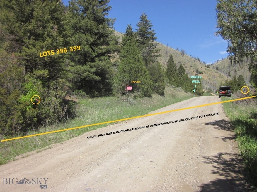
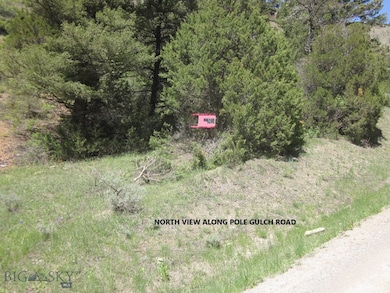
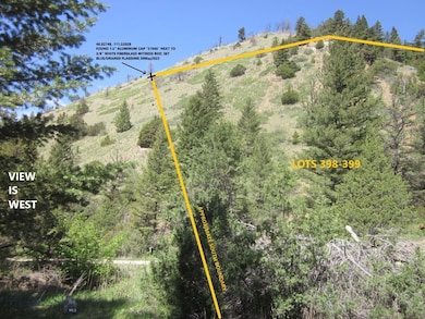
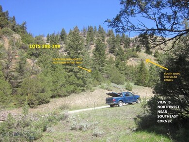
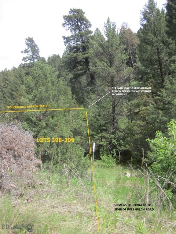
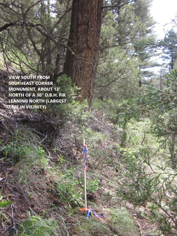
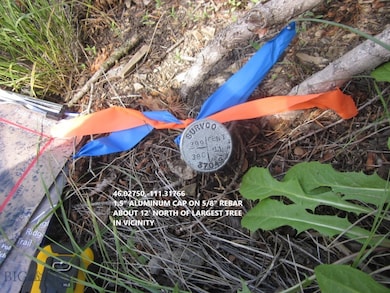
MOTIVATED SELLER dropped asking price by $3,000 on adjoining acreages in prime deer/elk country in time for the nearly 3-month archery/rifle big game seasons. Aggregated Lots 398-399 of 20.2 acres w/well in SE quadrant where access is year ‘round has great building site in the trees, & has alternate building site 600 vertical feet higher at NW corner w/breathtaking views, cool summer breezes, bountiful wildlife & 4x4-ATV access. Reportedly 750 head of elk reside in the area. Seller wants cash, so buyer should have some assets to use as collateral for a bank loan to pay seller with cash. Electricity is via solar, wind, propane, generator or a combo; a south-facing bare slope exists above the well for addition of a solar collector for maximum energy collection. Grey water could be via rainwater collection system from a roof. Water well on northwest side of Pole Gulch Road produces 5 gpm, static 76’, total depth 225’. Listing Broker is a licensed Professional Land Surveyor who recovered & flagged all 4 corner monuments with orange/blue ribbon & observed/recorded hand-held GPS coordinates shown in pictures; also, where the south boundary crosses Pole Gulch Road orange/blue ribbon was set on both sides of road. Property owners association disbanded about 2012 so covenants are no longer enforced. As of June 2023 access to upper northwest corner via Skyline Road is marginally passible in a 4x4 due to very deep, washed out ruts so alternate route of Pole Gulch Rd, to Spring Valley Rd, to Skyline Rd, to Lightning Ridge Trl is recommended. To generally navigate there, Buyer/Realtor may buy a 3’x4’ black & white map of Ponderosa Pines for about $8 at Selby’s Bozeman, UPS Store Belgrade, or Main St Office Three Forks if reminded that they were given a digital file of it by listing Broker/Surveyor-Mapper. Conifer timber cover has been burnt by a wildfire covering about two-thirds of the 20 acres, State forester estimates 10 years for regeneration; however, a densely treed draw in the southeast portion of property above the well would be a great building site for a cabin in the trees. PUBLIC LANDS lie 1.5 mi NE and SW; PUBLIC RIVER LANDS are 6 mi drive where entire river can be fished legally, or where one may watch migratory waterfowl or upland game birds being chased by eagles. Distance to I-90 is 20 min, to international airport 45 min. Google Earth the well in SE sector @ 46.02811,-111.31770, or NW corner spectacular-views cabin build sites at 46.03111,-111.32027
Property Details
Property Type
- Land
Est. Annual Taxes
- $464
Lot Details
- 20.2 Acre Lot
- South Facing Home
Property Views
- Lake
- Pond
- Farm
- Mountain
- Rural
- Valley
Listing and Financial Details
- Assessor Parcel Number rce127
Community Details
Overview
- No Home Owners Association
- Ponderosa Pines Subdivision
Recreation
- Park
Map
Home Values in the Area
Average Home Value in this Area
Property History
| Date | Event | Price | List to Sale | Price per Sq Ft |
|---|---|---|---|---|
| 09/03/2023 09/03/23 | Price Changed | $92,900 | -3.1% | -- |
| 11/07/2022 11/07/22 | For Sale | $95,900 | -- | -- |
Source: Big Sky Country MLS
MLS Number: 378991
Disclaimer: Certain information contained herein is derived from information provided by parties other than Homes.com. All information provided is deemed reliable, but is not guaranteed to be accurate and should be independently verified.
![]() IDX information is provided exclusively for consumers' personal, non-commercial use, that it may not be used for any purpose other than to identify prospective properties consumers may be interested in purchasing, and that the data is deemed reliable but is not guaranteed accurate by the MLS.
IDX information is provided exclusively for consumers' personal, non-commercial use, that it may not be used for any purpose other than to identify prospective properties consumers may be interested in purchasing, and that the data is deemed reliable but is not guaranteed accurate by the MLS.
- 357 Pole Gulch Rd
- TBD Horseshoe Hills Hollow
- 17248 Pole Gulch Rd
- 18600 Pole Gulch Rd
- 1435 Lone Wolf Trail
- Lot 396 Lightning Ridge Trail
- Lot 402 Lightning Ridge Trail
- TBD Lone Wolf Trail
- Lot 355 Pole Gulch Rd
- Lot 358 Pole Gulch Rd
- Lot 429 Tbd Skyline Rd
- Lot 31 Tbd Round Pole Dr
- 610 Wheat Field Rd
- 351 Broken Creek Rd
- 136 Broken Creek Rd
- 127 Hayden Taylor Rd
- TBD Drake Ln
- 12193 Old Coach Rd
- 12191 Old Coach Rd
- TBD Crystal Mountain Rd
- 108 3rd Ave E
- 307 First Ave E
- 419 1st Ave W
- 81 Old Yellowstone Trail
- 407 W Jefferson St
- 1807 Golden Dr W
- 92 13th St Unit B
- 448-448 W Shore Dr Unit 446
- 507 W Shore Dr
- 89 Village Dr Unit 3rd Floor 2 Bedroom
- 906 Powers Blvd
- 205 Fletching Way
- 705 Dakota St
- 703 Colorado St
- 91 E Rosebud Ave Unit A
- 900 Montana St
- 900 Montana St
- 17 Walnut
- 101 Abby St
- 303 Belgrade Blvd
