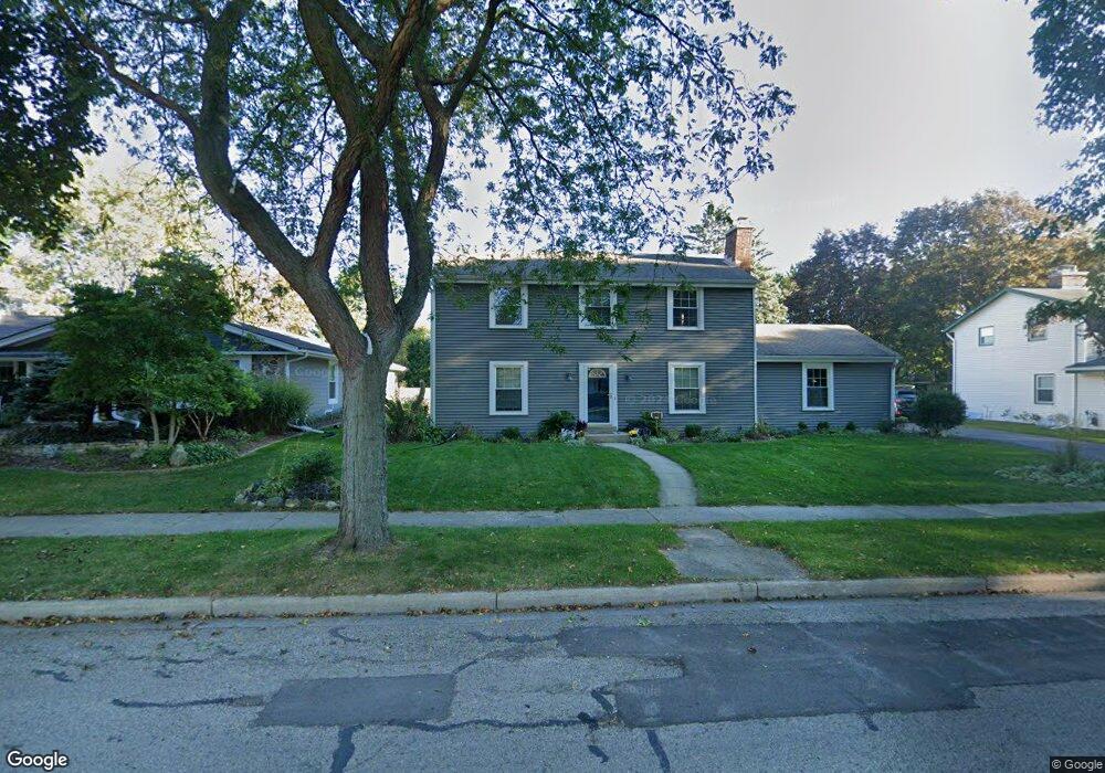
N100W5946 Oxford Dr Cedarburg, WI 53012
Estimated Value: $477,000 - $585,000
--
Bed
--
Bath
--
Sq Ft
0.3
Acres
About This Home
This home is located at N100W5946 Oxford Dr, Cedarburg, WI 53012 and is currently estimated at $510,206. N100W5946 Oxford Dr is a home located in Ozaukee County with nearby schools including Cedarburg High School, First Immanuel Lutheran School, and St Francis Borgia Catholic School.
Ownership History
Date
Name
Owned For
Owner Type
Purchase Details
Closed on
Feb 23, 2017
Sold by
Osheim Gary L and Osheim Cheryl J
Bought by
Hanusa Jonathan W and Hanusa Megan M
Current Estimated Value
Home Financials for this Owner
Home Financials are based on the most recent Mortgage that was taken out on this home.
Original Mortgage
$262,922
Outstanding Balance
$219,408
Interest Rate
4.4%
Mortgage Type
FHA
Estimated Equity
$290,798
Create a Home Valuation Report for This Property
The Home Valuation Report is an in-depth analysis detailing your home's value as well as a comparison with similar homes in the area
Home Values in the Area
Average Home Value in this Area
Purchase History
| Date | Buyer | Sale Price | Title Company |
|---|---|---|---|
| Hanusa Jonathan W | $272,000 | -- |
Source: Public Records
Mortgage History
| Date | Status | Borrower | Loan Amount |
|---|---|---|---|
| Open | Hanusa Jonathan W | $262,922 |
Source: Public Records
Tax History Compared to Growth
Tax History
| Year | Tax Paid | Tax Assessment Tax Assessment Total Assessment is a certain percentage of the fair market value that is determined by local assessors to be the total taxable value of land and additions on the property. | Land | Improvement |
|---|---|---|---|---|
| 2024 | $5,400 | $367,800 | $83,200 | $284,600 |
| 2023 | $4,987 | $367,800 | $83,200 | $284,600 |
| 2022 | $4,881 | $367,800 | $83,200 | $284,600 |
| 2021 | $4,513 | $258,700 | $75,600 | $183,100 |
| 2020 | $4,727 | $255,200 | $75,600 | $179,600 |
| 2019 | $4,640 | $255,200 | $75,600 | $179,600 |
| 2018 | $4,574 | $255,200 | $75,600 | $179,600 |
| 2017 | $4,359 | $246,500 | $75,600 | $170,900 |
| 2016 | $4,463 | $246,500 | $75,600 | $170,900 |
| 2015 | $4,344 | $246,500 | $75,600 | $170,900 |
| 2014 | $4,412 | $246,500 | $75,600 | $170,900 |
| 2013 | $4,626 | $246,500 | $75,600 | $170,900 |
Source: Public Records
Map
Nearby Homes
- N104W6262 Susan Ln
- N105W6300 Brenton Ln
- N105W6431 Stone Lake Cir Unit 32
- N106W6590 Stone Lake Cir Unit 10
- N106W6600 Stone Lake Cir Unit 9
- N105W6695 Stone Lake Cir Unit 5
- 1311 Dove Ln
- 331 Juniper Ct
- W68N921 Washington Ave
- 329 W Bridge St
- W67N786 Evergreen Blvd
- 1090 Canary Ct
- N69W6507 Bridge Rd
- 1339 Cedar Creek Pkwy
- W72N1047 Hampton Ave
- N114W7191 Oakmont Dr
- 2112 Pine Ridge Ct Unit F
- 2135 Pine Ridge Ct Unit D
- 2057 Chateau Ct
- Lt1 Bridge Rd
- N99W5905 Oxford Dr
- N100W5965 Oxford Dr
- N100W5926 Oxford Dr
- N100W5880 Oxford Dr
- W58N995 Essex Dr
- N100W5801 Buckingham Ct
- N99W5829 Oxford Dr
- N99W5820 Oxford Dr
- N98W5781 Oxford Dr
- W58N976 Essex Dr
- N101W5802 Buckingham Ct
- N101W5760 Buckingham Ct
- N101W5720 Buckingham Ct
- N101W5702 Buckingham Ct
- W58N965 Oxford Ct
- W58N967 Oxford Ct
- N100W5701 Buckingham Ct
- N100W5725 Buckingham Ct
- N100W5755 Buckingham Ct
- W57N969 Oxford Ct