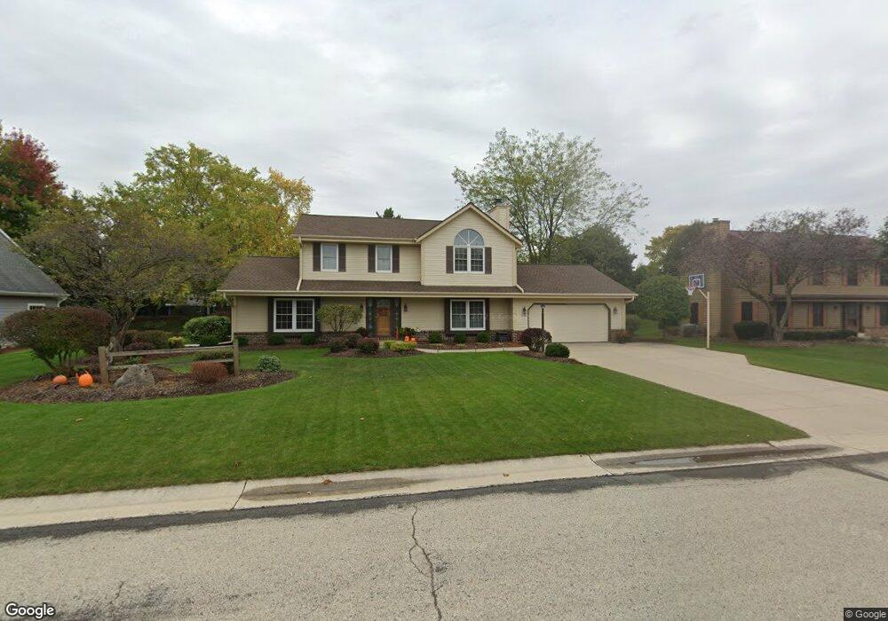
N102W15955 Flintlock Trail Germantown, WI 53022
Estimated Value: $482,000 - $540,000
3
Beds
4
Baths
2,364
Sq Ft
$212/Sq Ft
Est. Value
About This Home
This home is located at N102W15955 Flintlock Trail, Germantown, WI 53022 and is currently estimated at $500,550, approximately $211 per square foot. N102W15955 Flintlock Trail is a home located in Washington County with nearby schools including County Line Elementary School, Kennedy Middle School, and Germantown High School.
Ownership History
Date
Name
Owned For
Owner Type
Purchase Details
Closed on
Jul 3, 2014
Sold by
Barnes Daniel E and Barnes Bonnie S
Bought by
Barnes Daniel E and Barnes Bonnie S
Current Estimated Value
Purchase Details
Closed on
Feb 28, 2006
Sold by
Peters James H and Peters James
Bought by
Cansler Aaron Conrad and Barnes Emma Louise
Home Financials for this Owner
Home Financials are based on the most recent Mortgage that was taken out on this home.
Original Mortgage
$249,600
Outstanding Balance
$137,119
Interest Rate
5.89%
Mortgage Type
Adjustable Rate Mortgage/ARM
Estimated Equity
$363,431
Create a Home Valuation Report for This Property
The Home Valuation Report is an in-depth analysis detailing your home's value as well as a comparison with similar homes in the area
Home Values in the Area
Average Home Value in this Area
Purchase History
| Date | Buyer | Sale Price | Title Company |
|---|---|---|---|
| Barnes Daniel E | -- | None Available | |
| Cansler Aaron Conrad | $312,000 | None Available |
Source: Public Records
Mortgage History
| Date | Status | Borrower | Loan Amount |
|---|---|---|---|
| Open | Cansler Aaron Conrad | $249,600 |
Source: Public Records
Tax History Compared to Growth
Tax History
| Year | Tax Paid | Tax Assessment Tax Assessment Total Assessment is a certain percentage of the fair market value that is determined by local assessors to be the total taxable value of land and additions on the property. | Land | Improvement |
|---|---|---|---|---|
| 2024 | $5,600 | $439,000 | $98,500 | $340,500 |
| 2023 | $5,425 | $333,600 | $93,100 | $240,500 |
| 2022 | $5,402 | $333,600 | $93,100 | $240,500 |
| 2021 | $5,185 | $333,600 | $93,100 | $240,500 |
| 2020 | $5,389 | $333,600 | $93,100 | $240,500 |
| 2019 | $5,168 | $333,600 | $93,100 | $240,500 |
| 2018 | $5,084 | $305,000 | $71,800 | $233,200 |
| 2017 | $4,830 | $305,000 | $71,800 | $233,200 |
| 2016 | $4,752 | $302,400 | $71,800 | $230,600 |
| 2015 | $4,741 | $292,400 | $71,800 | $220,600 |
| 2014 | $4,746 | $284,100 | $71,800 | $212,300 |
| 2013 | $4,793 | $291,300 | $74,000 | $217,300 |
Source: Public Records
Map
Nearby Homes
- W154N10077 Moonlite Dr
- N101W16795 Gunflint Trail
- W165N10401 Wagon Trail
- The Rosebud Plan at Heritage Park North
- The Charlotte Plan at Heritage Park North
- The Madison Plan at Heritage Park North
- The Julia Plan at Heritage Park North
- The Aubrey Plan at Heritage Park North
- The Isabella Plan at Heritage Park North
- The Elsa Plan at Heritage Park North
- The Prescott Plan at Heritage Park North
- The Celina Plan at Heritage Park North
- The Geneva Plan at Heritage Park North
- The Neenah Plan at Heritage Park North
- N98W15894 Concord Rd
- W153N9883 Neptune Dr
- N106W16321 Old Farm Rd
- N99W16701 Woodcock Rd
- W168N10125 Bittersweet Trail
- W156N10904 Catskill Ln
- N102W15985 Flintlock Trail
- N102W15925 Flintlock Trail
- W159N10177 Comanche Ct
- W159N10178 Comanche Ct
- N102W15954 Flintlock Trail
- N102W15984 Flintlock Trail
- N102W15895 Flintlock Trail
- N102W15924 Flintlock Trail
- W159N10165 Comanche Ct
- W159N10166 Comanche Ct
- N102W15894 Flintlock Trail
- N102W15865 Flintlock Trail
- W160N10174 Cherokee Ct
- W160N10160 Cherokee Ct
- W159N10157 Comanche Ct
- W158N10165 Shoshone Ct
- N102W15862 Flintlock Trail
- W159N10158 Comanche Ct
- N102W15983 Yorktowne Ln
- N102W15953 Yorktowne Ln