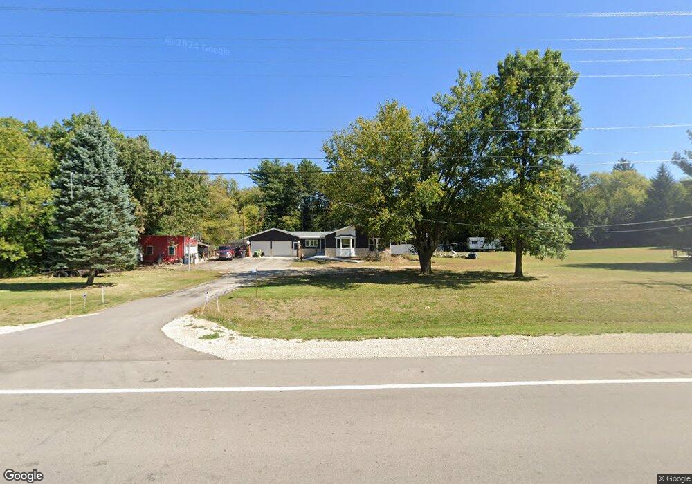
N1496 Us Highway 12 Fort Atkinson, WI 53538
Estimated Value: $352,000 - $407,000
--
Bed
--
Bath
--
Sq Ft
1.79
Acres
About This Home
This home is located at N1496 Us Highway 12, Fort Atkinson, WI 53538 and is currently estimated at $372,465. N1496 Us Highway 12 is a home with nearby schools including Purdy Elementary School, Fort Atkinson Middle School, and Fort Atkinson High School.
Ownership History
Date
Name
Owned For
Owner Type
Purchase Details
Closed on
Nov 14, 2023
Sold by
Larson Joanne C
Bought by
Joanne C Larson Irrevocable Trust
Current Estimated Value
Purchase Details
Closed on
Oct 22, 2021
Sold by
Larson Joanne C
Bought by
Wisconsin Department Of Transportation
Purchase Details
Closed on
Mar 1, 2017
Sold by
Larson Joanne C and Estate Of Gary Lynn Larson
Bought by
Larson Joanne C
Create a Home Valuation Report for This Property
The Home Valuation Report is an in-depth analysis detailing your home's value as well as a comparison with similar homes in the area
Home Values in the Area
Average Home Value in this Area
Purchase History
| Date | Buyer | Sale Price | Title Company |
|---|---|---|---|
| Joanne C Larson Irrevocable Trust | -- | None Listed On Document | |
| Wisconsin Department Of Transportation | $15,500 | None Available | |
| Larson Joanne C | -- | None Available |
Source: Public Records
Tax History Compared to Growth
Tax History
| Year | Tax Paid | Tax Assessment Tax Assessment Total Assessment is a certain percentage of the fair market value that is determined by local assessors to be the total taxable value of land and additions on the property. | Land | Improvement |
|---|---|---|---|---|
| 2024 | $4,230 | $231,100 | $50,300 | $180,800 |
| 2023 | $3,959 | $231,100 | $50,300 | $180,800 |
| 2022 | $4,115 | $231,100 | $50,300 | $180,800 |
| 2021 | $3,911 | $235,800 | $55,000 | $180,800 |
| 2020 | $3,469 | $235,800 | $55,000 | $180,800 |
| 2019 | $3,164 | $172,900 | $43,800 | $129,100 |
| 2018 | $2,942 | $172,900 | $43,800 | $129,100 |
| 2017 | $2,906 | $172,900 | $43,800 | $129,100 |
| 2016 | $3,011 | $172,900 | $43,800 | $129,100 |
| 2015 | $3,070 | $172,900 | $43,800 | $129,100 |
| 2014 | $2,986 | $172,900 | $43,800 | $129,100 |
| 2013 | $3,085 | $172,900 | $43,800 | $129,100 |
Source: Public Records
Map
Nearby Homes
- 263 Heritage Dr Unit 20
- 265 Heritage Dr Unit 19
- 205 Wollet Dr
- 1000 Whitetail Dr
- W6272 Apple Ln
- 1402 Adrian Blvd
- W6368 Briar Ln
- N1609 Pleasant Rd
- 1268 Jamesway
- N1657 Carlin Rd
- 633 Hilltop Trail W
- 611 Talcott Ave
- 206 Hilltop Trail
- Lot #9 Commerce Pkwy
- Lot #6 Commerce Pkwy
- Lot #10 Commerce Pkwy
- Lot #7 Commerce Pkwy
- Lot #1 Commerce Pkwy
- Lt0 County Rd N
- 233 S Water St E
- N1462 U S 12
- N1511 Us Highway 12
- N1450 Us Highway 12
- N1440 U S 12
- N1513 Us Highway 12
- N1422 U S 12
- N1556 Woodlawn Dr
- N1546 Knaack Ct
- N1558 Us Highway 12
- n 1577 Us Highway 12
- N1556 Knaack Ct
- 1546 Knaack Ct
- N1541 Knaack Ct
- N1551 Knaack Ct
- N1386 Us Highway 12
- N1568 Knaack Ct
- N1561 Knaack Ct
- Lot 3 Knaack Ct
- N1374 Us Highway 12
- N1579 Knaack Ct