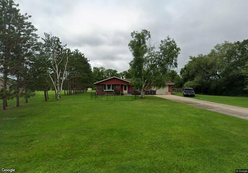
N1928 Parkview Cir Palmyra, WI 53156
Estimated Value: $326,000 - $488,000
--
Bed
--
Bath
--
Sq Ft
0.9
Acres
About This Home
This home is located at N1928 Parkview Cir, Palmyra, WI 53156 and is currently estimated at $381,149. N1928 Parkview Cir is a home located in Jefferson County with nearby schools including Palmyra-Eagle High School.
Ownership History
Date
Name
Owned For
Owner Type
Purchase Details
Closed on
Nov 14, 2019
Sold by
Stark Tony A
Bought by
Gale Michael and Gale Anna
Current Estimated Value
Home Financials for this Owner
Home Financials are based on the most recent Mortgage that was taken out on this home.
Original Mortgage
$195,395
Outstanding Balance
$171,966
Interest Rate
3.62%
Mortgage Type
FHA
Estimated Equity
$209,183
Purchase Details
Closed on
Oct 15, 2018
Sold by
Powell Michele M
Bought by
Stark Tory A
Home Financials for this Owner
Home Financials are based on the most recent Mortgage that was taken out on this home.
Original Mortgage
$172,000
Interest Rate
4.6%
Mortgage Type
New Conventional
Purchase Details
Closed on
Jun 28, 2006
Sold by
Manogue James L and Manogue Sherrie L
Bought by
Stark Tory A and Stark Michele M
Home Financials for this Owner
Home Financials are based on the most recent Mortgage that was taken out on this home.
Original Mortgage
$168,750
Interest Rate
6.72%
Mortgage Type
Purchase Money Mortgage
Create a Home Valuation Report for This Property
The Home Valuation Report is an in-depth analysis detailing your home's value as well as a comparison with similar homes in the area
Home Values in the Area
Average Home Value in this Area
Purchase History
| Date | Buyer | Sale Price | Title Company |
|---|---|---|---|
| Gale Michael | $199,000 | None Available | |
| Stark Tory A | -- | None Available | |
| Stark Tory A | $225,000 | None Available |
Source: Public Records
Mortgage History
| Date | Status | Borrower | Loan Amount |
|---|---|---|---|
| Open | Gale Michael | $195,395 | |
| Previous Owner | Stark Tory A | $172,000 | |
| Previous Owner | Stark Tory A | $168,750 |
Source: Public Records
Tax History Compared to Growth
Tax History
| Year | Tax Paid | Tax Assessment Tax Assessment Total Assessment is a certain percentage of the fair market value that is determined by local assessors to be the total taxable value of land and additions on the property. | Land | Improvement |
|---|---|---|---|---|
| 2024 | $3,454 | $205,600 | $53,000 | $152,600 |
| 2023 | $2,963 | $205,600 | $53,000 | $152,600 |
| 2022 | $2,809 | $205,600 | $53,000 | $152,600 |
| 2021 | $2,851 | $205,600 | $53,000 | $152,600 |
| 2020 | $2,979 | $205,600 | $53,000 | $152,600 |
| 2019 | $2,902 | $205,600 | $53,000 | $152,600 |
| 2018 | $2,930 | $205,600 | $53,000 | $152,600 |
| 2017 | $2,914 | $205,600 | $53,000 | $152,600 |
| 2016 | $2,895 | $205,600 | $53,000 | $152,600 |
| 2015 | $3,161 | $205,600 | $53,000 | $152,600 |
| 2014 | $3,127 | $205,600 | $53,000 | $152,600 |
| 2013 | $3,167 | $205,600 | $53,000 | $152,600 |
Source: Public Records
Map
Nearby Homes
- 314 Jefferson St
- 212 Mill Rd
- 210 N 2nd St
- 226 S 2nd St
- N2639 County Road z
- 227 S 3rd St
- 213 N Fourth St
- 620 Powers St
- W914 County Road CI
- W1306 N Blue Spring Lake Dr
- N3075 Hardscrabble Rd
- 542 Anton Ct
- W1260 S Shore Dr
- W1325 S Shore Dr
- 548 Kettle Moraine Dr Unit 1
- W397S11030 Chimney Rock
- W397 S11030 Chimney Rock
- W1446 S Shore Dr
- 214 Grove St
- 114 Grove St
- N1940 Parkview Cir
- W296 Pine Dr
- W280 Pine Dr
- W322 Pine Dr
- N1952 Parkview Cir
- N1935 Parkview Cir
- N1943 Parkview Cir
- W330 Pine Dr
- W268 Pine Dr
- N1966 Parkview Cir
- N1879 Parkview Cir
- N1969 Parkview Cir
- N1890 Parkview Cir
- N1976 Parkview Cir
- N1863 Parkview Cir
- N1669 County Road H
- N1723 Parkview Cir
- W323 Pine Dr
- N1851 Parkview Cir
- N1981 Parkview Cir