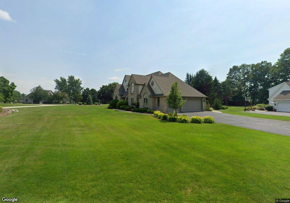
N32W23233 Fieldside Rd Pewaukee, WI 53072
Estimated Value: $739,000 - $947,000
--
Bed
--
Bath
--
Sq Ft
0.62
Acres
About This Home
This home is located at N32W23233 Fieldside Rd, Pewaukee, WI 53072 and is currently estimated at $816,413. N32W23233 Fieldside Rd is a home located in Waukesha County with nearby schools including Pewaukee Lake Elementary School, Asa Clark Middle School, and Pewaukee High School.
Ownership History
Date
Name
Owned For
Owner Type
Purchase Details
Closed on
Aug 29, 2001
Sold by
Reed Terrance B and Reed Cassandra M
Bought by
Balistreri James and Balistreri Judith
Current Estimated Value
Home Financials for this Owner
Home Financials are based on the most recent Mortgage that was taken out on this home.
Original Mortgage
$401,800
Outstanding Balance
$153,939
Interest Rate
6.75%
Mortgage Type
Purchase Money Mortgage
Estimated Equity
$662,474
Create a Home Valuation Report for This Property
The Home Valuation Report is an in-depth analysis detailing your home's value as well as a comparison with similar homes in the area
Home Values in the Area
Average Home Value in this Area
Purchase History
| Date | Buyer | Sale Price | Title Company |
|---|---|---|---|
| Balistreri James | $490,000 | -- |
Source: Public Records
Mortgage History
| Date | Status | Borrower | Loan Amount |
|---|---|---|---|
| Open | Balistreri James | $401,800 |
Source: Public Records
Tax History Compared to Growth
Tax History
| Year | Tax Paid | Tax Assessment Tax Assessment Total Assessment is a certain percentage of the fair market value that is determined by local assessors to be the total taxable value of land and additions on the property. | Land | Improvement |
|---|---|---|---|---|
| 2024 | $7,672 | $607,100 | $148,500 | $458,600 |
| 2023 | $7,312 | $607,100 | $148,500 | $458,600 |
| 2022 | $7,520 | $601,900 | $148,500 | $453,400 |
| 2021 | $7,800 | $601,900 | $148,500 | $453,400 |
| 2020 | $7,801 | $502,900 | $130,700 | $372,200 |
| 2019 | $7,625 | $502,900 | $130,700 | $372,200 |
| 2018 | $7,270 | $502,900 | $130,700 | $372,200 |
| 2017 | $7,131 | $502,900 | $130,700 | $372,200 |
| 2016 | $7,259 | $502,900 | $130,700 | $372,200 |
| 2015 | $7,345 | $502,900 | $130,700 | $372,200 |
| 2014 | $8,024 | $502,900 | $130,700 | $372,200 |
| 2013 | $8,024 | $502,900 | $130,700 | $372,200 |
Source: Public Records
Map
Nearby Homes
- W233N3088 Oakmont Ct E Unit B
- N35W23701 Auburn Ct Unit 1
- W229N3655 Sterling Ct
- N28W22352 Foxwood Ln
- N26W22577 Oakwood Ln
- N42W22833 Beacon Ct
- N25W24117 River Park Dr Unit 2
- N24W22420 Meadowood Ln
- W241N2573 E Parkway Meadow Cir Unit 3
- W240N2500 E Parkway Meadow Cir Unit 8
- W241N2507 E Parkway Meadow Cir Unit 6
- 1339 Hillwood Blvd Unit D
- 509 Westfield Way Unit F
- N45W22742 Charlotte Way
- 21445 Gumina Rd
- W243N2280 Deer Park Dr Unit A
- 1023 Waterstone Ct
- 2550 Harmony Cir
- W221N4524 Timber Dr
- 21710 Astolat Dr
- N32W23255 Fieldside Rd
- W232N3239 Greenbriar Rd
- W232N3250 Greenbriar Rd
- W232N3242 Greenbriar Rd
- W232N3219 Greenbriar Rd
- W232N3291 Greenbriar Rd
- N32W23234 Fieldside Rd
- W232N3296 Greenbriar Rd
- N32W23262 Fieldside Rd
- N32W23175 Stonewall Ct
- W232N3211 Greenbriar Rd
- W232N3329 Greenbriar Rd
- W232N3216 Greenbriar Rd
- N32W23270 Fieldside Rd
- N32W23170 Stonewall Ct
- N32W23163 Stonewall Ct
- N32W23292 Fieldside Rd
- N33W23197 Greenbriar Rd
- W232N3320 Greenbriar Rd
- W232N3197 Greenbriar Rd