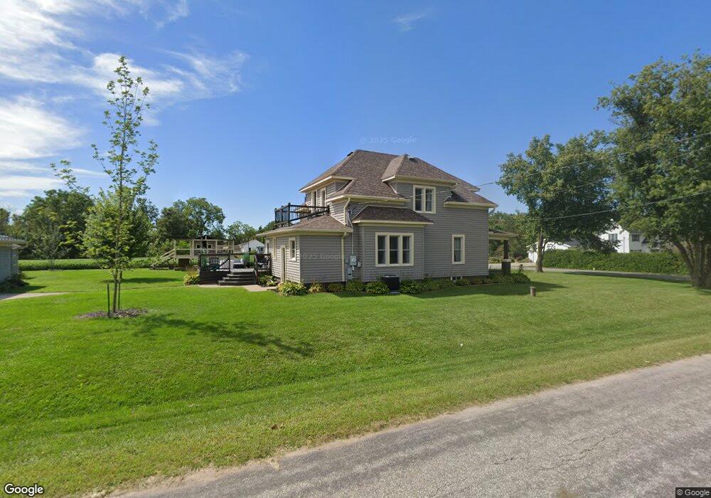
N37141 Thompson Coulee Rd Whitehall, WI 54773
Estimated Value: $204,000 - $272,624
3
Beds
2
Baths
2,520
Sq Ft
$97/Sq Ft
Est. Value
About This Home
This home is located at N37141 Thompson Coulee Rd, Whitehall, WI 54773 and is currently estimated at $243,875, approximately $96 per square foot. N37141 Thompson Coulee Rd is a home located in Trempealeau County with nearby schools including Whitehall Memorial Elementary School, Whitehall Memorial Jr./Sr. High School, and Fly Creek Amish School.
Ownership History
Date
Name
Owned For
Owner Type
Purchase Details
Closed on
Feb 14, 2014
Sold by
Kulig Kendall J and Kulig Elsa W
Bought by
Dittmann Zachary G
Current Estimated Value
Home Financials for this Owner
Home Financials are based on the most recent Mortgage that was taken out on this home.
Original Mortgage
$124,800
Outstanding Balance
$95,068
Interest Rate
4.55%
Mortgage Type
Purchase Money Mortgage
Estimated Equity
$148,807
Purchase Details
Closed on
Apr 18, 2008
Sold by
Worley David A and Worley Linda M
Bought by
Johnston Michael T and Johnston Erika B
Home Financials for this Owner
Home Financials are based on the most recent Mortgage that was taken out on this home.
Original Mortgage
$127,943
Interest Rate
5.93%
Mortgage Type
New Conventional
Create a Home Valuation Report for This Property
The Home Valuation Report is an in-depth analysis detailing your home's value as well as a comparison with similar homes in the area
Home Values in the Area
Average Home Value in this Area
Purchase History
| Date | Buyer | Sale Price | Title Company |
|---|---|---|---|
| Dittmann Zachary G | $156,000 | Total Title Services Llc | |
| Johnston Michael T | $131,900 | Totle Title Services Llc |
Source: Public Records
Mortgage History
| Date | Status | Borrower | Loan Amount |
|---|---|---|---|
| Open | Dittmann Zachary G | $124,800 | |
| Previous Owner | Johnston Michael T | $127,943 |
Source: Public Records
Tax History Compared to Growth
Tax History
| Year | Tax Paid | Tax Assessment Tax Assessment Total Assessment is a certain percentage of the fair market value that is determined by local assessors to be the total taxable value of land and additions on the property. | Land | Improvement |
|---|---|---|---|---|
| 2024 | $2,815 | $174,500 | $16,500 | $158,000 |
| 2023 | $2,592 | $174,400 | $16,400 | $158,000 |
| 2022 | $2,296 | $174,400 | $16,400 | $158,000 |
| 2021 | $3,180 | $164,300 | $4,800 | $159,500 |
| 2020 | $3,471 | $20,750 | $4,800 | $15,950 |
| 2019 | $3,459 | $164,300 | $4,800 | $159,500 |
| 2018 | $2,931 | $154,800 | $4,800 | $150,000 |
| 2017 | $2,866 | $154,800 | $4,800 | $150,000 |
| 2016 | $2,852 | $154,900 | $4,900 | $150,000 |
| 2015 | $2,649 | $154,900 | $4,900 | $150,000 |
| 2014 | $2,641 | $154,900 | $4,900 | $150,000 |
| 2011 | $2,494 | $154,900 | $4,900 | $150,000 |
Source: Public Records
Map
Nearby Homes
- N36836 Us Highway 53 121
- 36290 Camp St
- 18144 Anderson St
- 18124 Fredrickson St
- 36015 Main St
- 18430 Hillside Dr
- N34855 County Rd S
- N34701 County Rd N
- 39971 Anderson St
- 39885 Winsand Dr
- N32838 Briten Rd
- 40257 Olson St
- W12198 County Road P
- XX Vold Rd
- N34701 County Rd S
- 517 W Broadway St
- 102 S Peterson Ave
- 127 E Broadway St
- 328 S Urberg Ave
- 612 E Broadway St
- W16614 Brittani Ln
- N37198 Thompson Coulee Rd
- W16633 Brittani Ln
- W16533 Brittani Ln
- W16684 Brittani Ln
- W16534 Brittani Ln
- N37077 Us Highway 53 121
- 16687 Brittani Ln
- W16687 Brittani Ln
- W16688 Brittani Ln
- N37066 County Road S
- N37048 Us Highway 53 121
- n 37048 Us Highway 53 121
- N37053 County Road S
- N37048 U S 53
- N37159 Us Highway 53 121
- 16724 Brittani Ln
- W16703 Brittani Ln
- W16724 Brittani Ln
- N36976 Us Highway 53 121