Estimated Value: $335,630 - $394,000
Studio
--
Bath
--
Sq Ft
431,680
Sq Ft Lot
About This Home
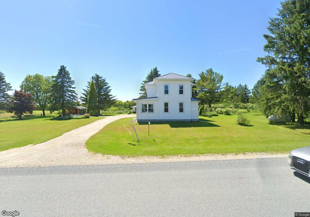
This home is located at N3804 County Rd E, Waldo, WI 53093 and is currently estimated at $368,877. N3804 County Rd E is a home located in Sheboygan County with nearby schools including Plymouth High School.
Ownership History
Date
Name
Owned For
Owner Type
Purchase Details
Closed on
Aug 20, 2021
Sold by
Sauermilch Laura A
Bought by
Mcclyman Caley and Benson James
Current Estimated Value
Home Financials for this Owner
Home Financials are based on the most recent Mortgage that was taken out on this home.
Original Mortgage
$211,500
Outstanding Balance
$191,737
Interest Rate
2.7%
Mortgage Type
New Conventional
Estimated Equity
$177,140
Purchase Details
Closed on
Sep 1, 2016
Sold by
Sauermilch Laura A and Sauermilch Laura A
Bought by
Sauermilch Sauermilch and Sauermilch John
Purchase Details
Closed on
Apr 30, 2015
Sold by
Sauermilch John
Bought by
Schmidt Gloria L
Create a Home Valuation Report for This Property
The Home Valuation Report is an in-depth analysis detailing your home's value as well as a comparison with similar homes in the area
Purchase History
| Date | Buyer | Sale Price | Title Company |
|---|---|---|---|
| Mcclyman Caley | $235,000 | Land Title | |
| Sauermilch Laura A | -- | Land Title | |
| Sauermilch Sauermilch | $160,000 | -- | |
| Schmidt Gloria L | $167,500 | -- |
Source: Public Records
Mortgage History
| Date | Status | Borrower | Loan Amount |
|---|---|---|---|
| Open | Mcclyman Caley | $211,500 |
Source: Public Records
Tax History
| Year | Tax Paid | Tax Assessment Tax Assessment Total Assessment is a certain percentage of the fair market value that is determined by local assessors to be the total taxable value of land and additions on the property. | Land | Improvement |
|---|---|---|---|---|
| 2024 | $4,015 | $225,900 | $57,600 | $168,300 |
| 2023 | $3,303 | $215,600 | $57,600 | $158,000 |
| 2022 | $2,777 | $199,200 | $57,600 | $141,600 |
| 2021 | $2,891 | $199,200 | $57,600 | $141,600 |
| 2020 | $2,967 | $199,200 | $57,600 | $141,600 |
| 2019 | $3,066 | $198,200 | $45,600 | $152,600 |
| 2018 | $3,013 | $198,200 | $45,600 | $152,600 |
| 2017 | $2,961 | $192,000 | $45,600 | $146,400 |
| 2016 | $3,142 | $192,000 | $45,600 | $146,400 |
| 2015 | $3,098 | $192,000 | $45,600 | $146,400 |
| 2014 | $2,974 | $192,000 | $45,600 | $146,400 |
Source: Public Records
Map
Nearby Homes
- 627 Bobolink Ln
- Lt0 County Rd N
- TBD Blueberry Ln
- 310 Madison Ave
- Lt3 Mowtown Dr
- Tbd Blueberry Ln
- 348 W 1st St
- N3429 Highview Rd
- 1403 Greystone Dr
- Lt54 Upper Greystone Dr
- Lt55 Upper Greystone Dr
- Lt61 Upper Greystone Dr
- Lt65 Upper Greystone Dr
- Lt64 Upper Greystone Dr
- Lt53 Upper Greystone Dr
- 214 S Hills Ct Unit 214
- w 4568 County Road F
- 1138 Prairie Rd
- N5578 County Road Zz
- 1515 Hummingbird Ln
- N3785 County Rd E
- N3852 County Rd E
- N3873 County Rd E
- N3900 County Rd E
- Lt1 County Rd E
- Lt1 County Rd E Unit Lt1
- W5824 County Road V
- W5758 County Road V
- N3615 County Rd E
- W6061 County Road V
- W6085 County Road V
- W6102 County Road V
- W6070 County Road V
- W6001 County Road V
- W5796 Wisconsin 28
- W5701 County Road V
- W5796 Highway 28
- W5796 State Road 28 Unit W5796
- N3650 Timberview Rd
- W5846 State Road 28
Your Personal Tour Guide
Ask me questions while you tour the home.