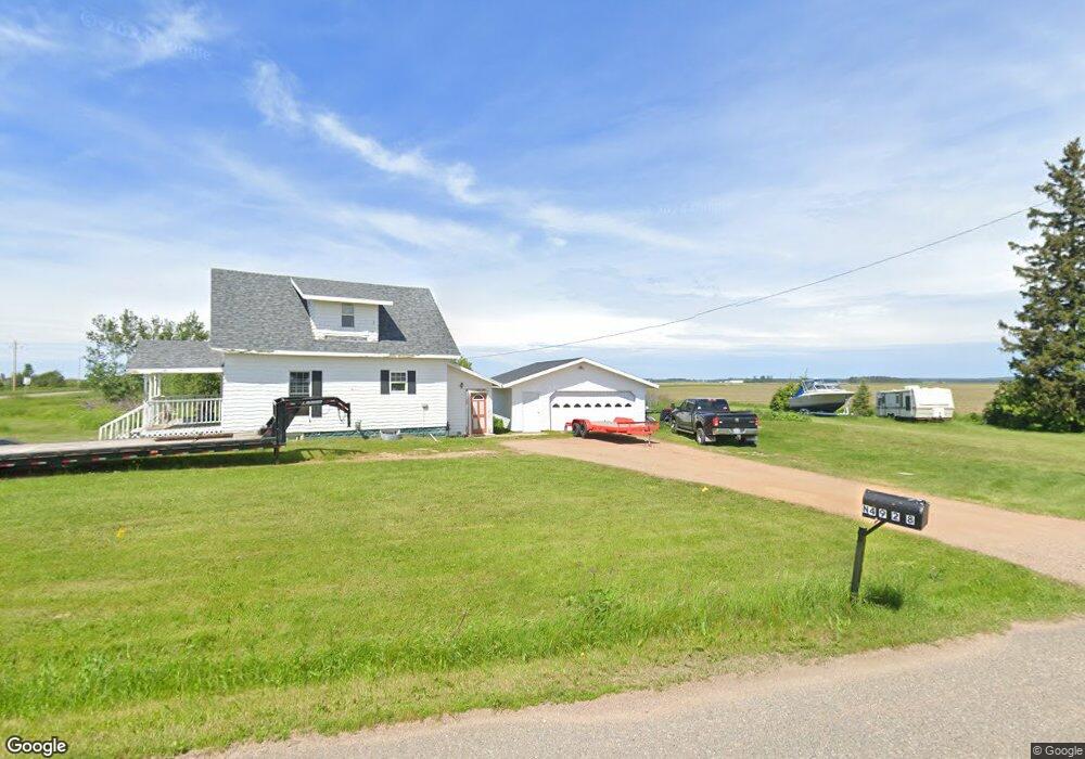
N4928 State Highway 52 Bryant, WI 54418
Estimated Value: $145,000 - $212,000
--
Bed
--
Bath
--
Sq Ft
1.16
Acres
About This Home
This home is located at N4928 State Highway 52, Bryant, WI 54418 and is currently estimated at $174,262. N4928 State Highway 52 is a home located in Langlade County with nearby schools including Antigo High School.
Ownership History
Date
Name
Owned For
Owner Type
Purchase Details
Closed on
May 12, 2021
Sold by
Js Cntry Acres Inc
Bought by
Williams Shawn
Current Estimated Value
Purchase Details
Closed on
Dec 20, 2018
Sold by
Kuhr Steve D and Kuhr Sharon A
Bought by
Js Cntry Acres Inc
Purchase Details
Closed on
Mar 28, 2017
Sold by
Carrington Mortgage Services Llc
Bought by
Kuhr Steve
Purchase Details
Closed on
Aug 3, 2016
Sold by
Williams Carrie
Bought by
Carrington Mortgage Services Llc
Create a Home Valuation Report for This Property
The Home Valuation Report is an in-depth analysis detailing your home's value as well as a comparison with similar homes in the area
Home Values in the Area
Average Home Value in this Area
Purchase History
| Date | Buyer | Sale Price | Title Company |
|---|---|---|---|
| Williams Shawn | $90,000 | -- | |
| Js Cntry Acres Inc | $16,000 | -- | |
| Kuhr Steve | $12,000 | -- | |
| Carrington Mortgage Services Llc | $46,800 | -- |
Source: Public Records
Tax History Compared to Growth
Tax History
| Year | Tax Paid | Tax Assessment Tax Assessment Total Assessment is a certain percentage of the fair market value that is determined by local assessors to be the total taxable value of land and additions on the property. | Land | Improvement |
|---|---|---|---|---|
| 2024 | $1,377 | $132,600 | $8,000 | $124,600 |
| 2023 | $1,167 | $98,500 | $5,900 | $92,600 |
| 2022 | $1,244 | $98,500 | $5,900 | $92,600 |
| 2021 | $1,318 | $98,500 | $5,900 | $92,600 |
| 2020 | $785 | $50,400 | $4,400 | $46,000 |
| 2019 | $407 | $30,100 | $4,400 | $25,700 |
| 2018 | $496 | $37,600 | $4,400 | $33,200 |
| 2016 | $803 | $56,400 | $4,400 | $52,000 |
| 2015 | $944 | $69,200 | $6,300 | $62,900 |
| 2014 | $965 | $69,200 | $6,300 | $62,900 |
| 2013 | $994 | $69,200 | $6,300 | $62,900 |
Source: Public Records
Map
Nearby Homes
- W5880 Old Rd E
- W4982 Harmon Rd
- N3172 County Hwy S
- N2862 Crestwood Rd
- N5134 Star Neva Rd
- W8897 Cth F
- N Firelane Rd Unit 6199
- W4210 County Road A
- 725 Ar-Vi Ln
- W9196 Birchwood Ln
- OFF Piela Ln
- W3174 W Hollister Rd
- n4704 U S 45
- 826 Eastview Dr
- 222 North Ave
- 000 Industrial Park Rd
- N7764 Wisconsin 52
- 228 North Ave
- N7799 Marshal Ln
- 1813 Neva Rd
- N4928 State Highway 52
- N4928 State Highway 52
- N4818 Price Polar Rd
- N4888 Hill Rd
- N4753 Price Polar Rd
- ON Price-Polar Rd Unit 5
- ON Price-Polar Rd Unit 4
- ON Price-Polar Rd
- N4795 Price Polar Rd
- ON Price Polar Rd
- ON Price Polar Rd Unit 20 Acres
- N4630 Price Polar Rd
- N4712 River Rd
- N4691 Carter Rd
- N4608 Price Polar Rd
- N460 Hillview Rd
- W7480 Cth O
- N4517 Price Polar Rd
- W6399 Oak Rd
- W6421 Oak Rd