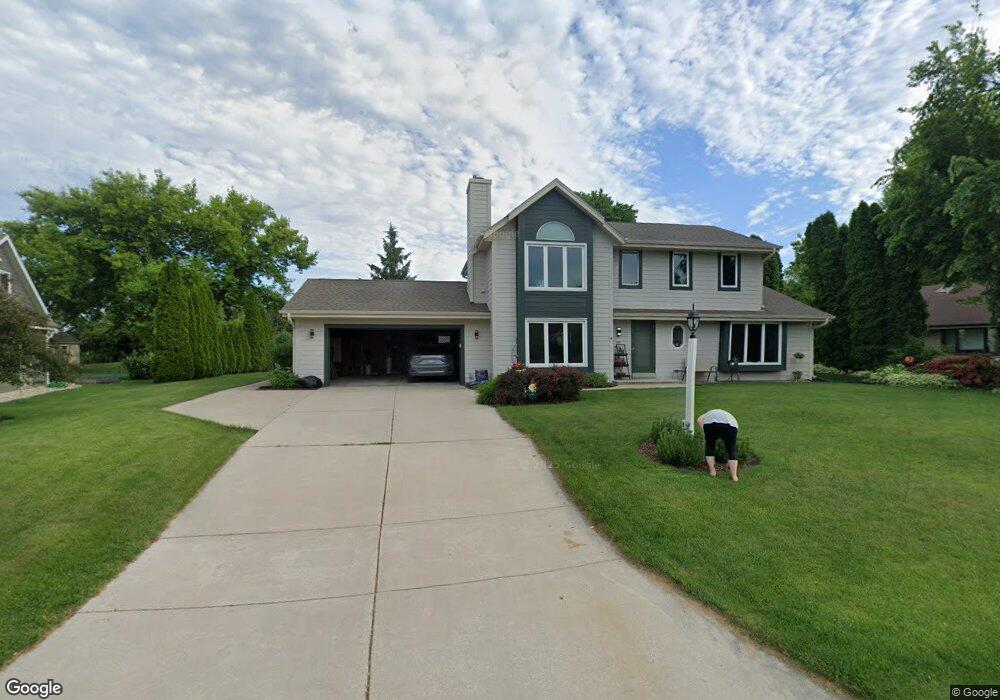
N53W14139 Saint Andrews Dr Menomonee Falls, WI 53051
Estimated Value: $504,000 - $556,000
3
Beds
3
Baths
2,113
Sq Ft
$250/Sq Ft
Est. Value
About This Home
This home is located at N53W14139 Saint Andrews Dr, Menomonee Falls, WI 53051 and is currently estimated at $529,297, approximately $250 per square foot. N53W14139 Saint Andrews Dr is a home located in Waukesha County with nearby schools including Valley View Elementary School, North Middle School, and Menomonee Falls High School.
Ownership History
Date
Name
Owned For
Owner Type
Purchase Details
Closed on
Nov 26, 2020
Sold by
Schwarz Robert M and Schwarz Dorothy Eb
Bought by
Schwarz Robert M and Schwarz Dorothy Eb
Current Estimated Value
Purchase Details
Closed on
Nov 23, 2020
Sold by
Schwarz Robert M and Schwarz Dorothy E
Bought by
Schwarz Stephen R and Schwarz Adam M
Create a Home Valuation Report for This Property
The Home Valuation Report is an in-depth analysis detailing your home's value as well as a comparison with similar homes in the area
Home Values in the Area
Average Home Value in this Area
Purchase History
| Date | Buyer | Sale Price | Title Company |
|---|---|---|---|
| Schwarz Robert M | -- | None Listed On Document | |
| Schwarz Stephen R | -- | None Available |
Source: Public Records
Tax History Compared to Growth
Tax History
| Year | Tax Paid | Tax Assessment Tax Assessment Total Assessment is a certain percentage of the fair market value that is determined by local assessors to be the total taxable value of land and additions on the property. | Land | Improvement |
|---|---|---|---|---|
| 2024 | $4,958 | $438,800 | $132,400 | $306,400 |
| 2023 | $4,773 | $438,800 | $132,400 | $306,400 |
| 2022 | $4,577 | $284,200 | $91,100 | $193,100 |
| 2021 | $4,381 | $284,200 | $91,100 | $193,100 |
| 2020 | $4,602 | $284,200 | $91,100 | $193,100 |
| 2019 | $4,405 | $284,200 | $91,100 | $193,100 |
| 2018 | $4,634 | $284,200 | $91,100 | $193,100 |
| 2017 | $4,790 | $284,200 | $91,100 | $193,100 |
| 2016 | $4,876 | $284,200 | $91,100 | $193,100 |
| 2015 | $4,882 | $284,200 | $91,100 | $193,100 |
| 2014 | $5,197 | $284,200 | $91,100 | $193,100 |
| 2013 | $5,197 | $284,200 | $91,100 | $193,100 |
Source: Public Records
Map
Nearby Homes
- N52W14491 Aryshire Ct
- Lt7-8 Lucille Ln
- N48W14336 Hampton Rd
- W144N4822 Stone Dr Unit C
- W156N5364 Bette Dr
- N60W13464 Tall Oak Ct
- 4685 N 150th St
- W136N6291 Hummingbird Way
- 4685 Pilgrim Rd
- W162N5492 Westwind Dr Unit 2
- N64W14282 Mill Rd
- N63W13412 Hummingbird Way
- N64W14182 Mill Rd
- 5861 N 121st St
- 4465 Pilgrim Rd
- 12012 W Florist Ave
- 4460 N 158th St
- 5253 N Lovers Lane Rd Unit 232
- W130N6462 Crestwood Dr
- N65W14542 Redwood Dr
- N53W14111 Saint Andrews Dr
- N53W14173 Saint Andrews Dr
- W141N5286 Thornhill Ct
- N53W14138 Saint Andrews Dr
- N53W14172 Saint Andrews Dr
- N53W14205 Saint Andrews Dr
- W141N5272 Thornhill Ct
- W140N5323 Saint Andrews Cir
- N53W14200 Saint Andrews Dr
- W141N5275 Thornhill Ct
- W140N5341 Saint Andrews Dr
- W140N5317 Lilly Rd
- N52W14236 Aberdeen Dr
- N52W14220 Aberdeen Dr
- W141N5268 Thornhill Ct
- W140N5331 Saint Andrews Cir
- W140N5301 Lilly Rd
- W140N5301 Lilly Rd
- W141N5261 Thornhill Ct
- W140N5305 Lilly Rd