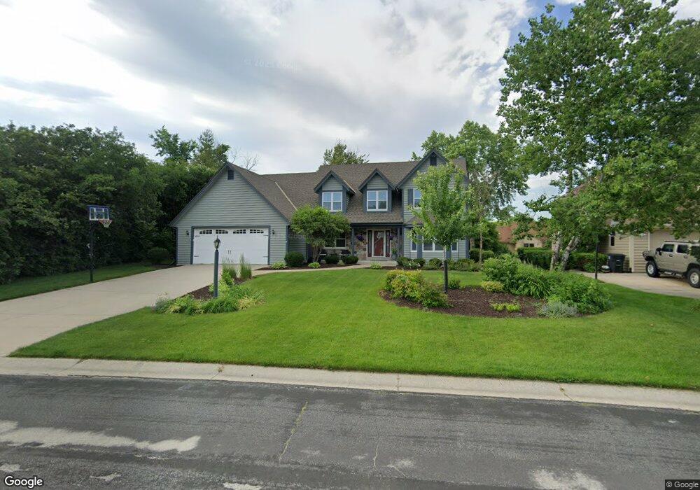
N53W14200 Saint Andrews Dr Menomonee Falls, WI 53051
Estimated Value: $580,000 - $632,000
4
Beds
3
Baths
2,479
Sq Ft
$246/Sq Ft
Est. Value
About This Home
This home is located at N53W14200 Saint Andrews Dr, Menomonee Falls, WI 53051 and is currently estimated at $608,939, approximately $245 per square foot. N53W14200 Saint Andrews Dr is a home located in Waukesha County with nearby schools including Valley View Elementary School, North Middle School, and Menomonee Falls High School.
Ownership History
Date
Name
Owned For
Owner Type
Purchase Details
Closed on
Aug 5, 2008
Sold by
Henrichs Timothy R and Henrichs Michelle M
Bought by
Gerbitz Pete T and Gerbitz Lori C
Current Estimated Value
Home Financials for this Owner
Home Financials are based on the most recent Mortgage that was taken out on this home.
Original Mortgage
$276,720
Outstanding Balance
$183,481
Interest Rate
6.54%
Mortgage Type
Purchase Money Mortgage
Estimated Equity
$425,458
Purchase Details
Closed on
Apr 25, 2005
Sold by
Young Stanley L and Young Jane M
Bought by
Henrichs Timothy R and Henrichs Michelle M
Home Financials for this Owner
Home Financials are based on the most recent Mortgage that was taken out on this home.
Original Mortgage
$280,000
Interest Rate
6.13%
Mortgage Type
Fannie Mae Freddie Mac
Create a Home Valuation Report for This Property
The Home Valuation Report is an in-depth analysis detailing your home's value as well as a comparison with similar homes in the area
Home Values in the Area
Average Home Value in this Area
Purchase History
| Date | Buyer | Sale Price | Title Company |
|---|---|---|---|
| Gerbitz Pete T | $345,900 | None Available | |
| Henrichs Timothy R | $350,000 | -- |
Source: Public Records
Mortgage History
| Date | Status | Borrower | Loan Amount |
|---|---|---|---|
| Open | Gerbitz Pete T | $276,720 | |
| Previous Owner | Henrichs Timothy R | $280,000 |
Source: Public Records
Tax History Compared to Growth
Tax History
| Year | Tax Paid | Tax Assessment Tax Assessment Total Assessment is a certain percentage of the fair market value that is determined by local assessors to be the total taxable value of land and additions on the property. | Land | Improvement |
|---|---|---|---|---|
| 2024 | $5,976 | $527,200 | $134,600 | $392,600 |
| 2023 | $5,760 | $527,200 | $134,600 | $392,600 |
| 2022 | $5,887 | $363,500 | $92,700 | $270,800 |
| 2021 | $5,237 | $338,300 | $92,700 | $245,600 |
| 2020 | $5,493 | $338,300 | $92,700 | $245,600 |
| 2019 | $5,263 | $338,300 | $92,700 | $245,600 |
| 2018 | $5,545 | $338,300 | $92,700 | $245,600 |
| 2017 | $5,722 | $338,300 | $92,700 | $245,600 |
| 2016 | $5,828 | $338,300 | $92,700 | $245,600 |
| 2015 | $5,830 | $338,300 | $92,700 | $245,600 |
| 2014 | $6,201 | $338,300 | $92,700 | $245,600 |
| 2013 | $6,201 | $338,300 | $92,700 | $245,600 |
Source: Public Records
Map
Nearby Homes
- N52W14491 Aryshire Ct
- N48W14336 Hampton Rd
- W144N4822 Stone Dr Unit C
- Lt7-8 Lucille Ln
- W156N5364 Bette Dr
- 4685 N 150th St
- N60W13464 Tall Oak Ct
- 4685 Pilgrim Rd
- W136N6291 Hummingbird Way
- W162N5492 Westwind Dr Unit 2
- 4465 Pilgrim Rd
- N64W14282 Mill Rd
- N64W14182 Mill Rd
- N63W13412 Hummingbird Way
- 4460 N 158th St
- 4560 N 161st St
- 5861 N 121st St
- 12012 W Florist Ave
- 5253 N Lovers Lane Rd Unit 232
- 16225 Elderlawn Pkwy
- N53W14172 Saint Andrews Dr
- N53W14205 Saint Andrews Dr
- N53W14173 Saint Andrews Dr
- N52W14236 Aberdeen Dr
- N53W14138 Saint Andrews Dr
- N53W14139 Saint Andrews Dr
- N53W14203 Invery Dr
- N53W14231 Invery Dr
- N53W14300 Aberdeen Dr
- N53W14179 Invery Dr
- N52W14220 Aberdeen Dr
- W141N5272 Thornhill Ct
- N53W14263 Invery Dr
- N53W14111 Saint Andrews Dr
- W140N5341 Saint Andrews Dr
- N53W14147 Invery Dr
- W141N5286 Thornhill Ct
- W141N5268 Thornhill Ct
- N53W14315 Aberdeen Dr
- N53W14202 Invery Dr