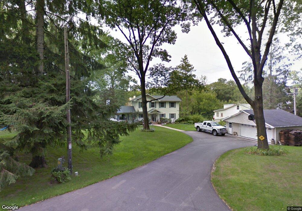
N7637 Pleasant Point Cir Elkhorn, WI 53121
Estimated Value: $1,264,000 - $2,069,000
--
Bed
--
Bath
--
Sq Ft
0.36
Acres
About This Home
This home is located at N7637 Pleasant Point Cir, Elkhorn, WI 53121 and is currently estimated at $1,602,150. N7637 Pleasant Point Cir is a home located in Walworth County with nearby schools including Tibbets Elementary School, Elkhorn Area Middle School, and Elkhorn Area High School.
Ownership History
Date
Name
Owned For
Owner Type
Purchase Details
Closed on
Dec 3, 2012
Sold by
Angst Jeffrey S and Angst Stephanie K
Bought by
Angst Jeffrey S and Angst Stephanie K
Current Estimated Value
Home Financials for this Owner
Home Financials are based on the most recent Mortgage that was taken out on this home.
Original Mortgage
$378,000
Outstanding Balance
$259,896
Interest Rate
3.36%
Mortgage Type
New Conventional
Estimated Equity
$1,342,254
Create a Home Valuation Report for This Property
The Home Valuation Report is an in-depth analysis detailing your home's value as well as a comparison with similar homes in the area
Home Values in the Area
Average Home Value in this Area
Purchase History
| Date | Buyer | Sale Price | Title Company |
|---|---|---|---|
| Angst Jeffrey S | -- | None Available |
Source: Public Records
Mortgage History
| Date | Status | Borrower | Loan Amount |
|---|---|---|---|
| Open | Angst Jeffrey S | $378,000 |
Source: Public Records
Tax History Compared to Growth
Tax History
| Year | Tax Paid | Tax Assessment Tax Assessment Total Assessment is a certain percentage of the fair market value that is determined by local assessors to be the total taxable value of land and additions on the property. | Land | Improvement |
|---|---|---|---|---|
| 2024 | $11,797 | $831,000 | $541,200 | $289,800 |
| 2023 | $11,729 | $831,000 | $541,200 | $289,800 |
| 2022 | $11,487 | $831,000 | $541,200 | $289,800 |
| 2021 | $10,988 | $831,000 | $541,200 | $289,800 |
| 2020 | $10,889 | $831,000 | $541,200 | $289,800 |
| 2019 | $11,021 | $831,000 | $541,200 | $289,800 |
| 2018 | $11,521 | $789,400 | $504,200 | $285,200 |
| 2017 | $11,572 | $789,400 | $504,200 | $285,200 |
| 2016 | $11,763 | $789,400 | $504,200 | $285,200 |
| 2015 | $11,819 | $789,400 | $504,200 | $285,200 |
| 2014 | $13,222 | $789,400 | $504,200 | $285,200 |
| 2013 | $13,222 | $789,400 | $504,200 | $285,200 |
Source: Public Records
Map
Nearby Homes
- N7686 Rendell Dr
- W5074 Hawk Rd
- W5357 Lauderdale Dr
- W5353 Lauderdale Dr
- Lt0 Lost Nation Rd
- W5539 Oak Park Rd
- W5505 Rocky Rd
- W5518 Lost Nation Rd
- W5180 Jason Rd
- Lt1 Lost Nation Rd
- W5303 Briarwood Rd
- N7450 Carriage Dr
- W5680 Ridge Rd
- W5712 North Dr
- W5737 North Dr
- Lt0 Kenosha Dr
- W5789 Ridge Rd
- LT40 Lakeshore Ave
- Lt0 Green Lake Dr
- Lt3
- N7631 Pleasant Point Cir
- N7627 Pleasant Point Cir
- N7665 Rendell Dr
- N7623 Pleasant Point Cir
- N7673 Rendell Dr
- N7622 Pleasant Point Cir
- N7619 Pleasant Point Cir
- N7630 Pleasant Point Cir
- W5187 Stewart Dr
- N7683 Rendell Dr
- N7651 Rendell Dr
- W5195 Stewart Dr
- N7626 Pleasant Point Cir
- W5207 Stewart Dr
- N7672 Rendell Dr
- N7636 Pleasant Point Cir
- N7635 Rendell Dr
- N7678 Rendell Dr
- W5152 Bayshore Dr
- W5146 Bayshore Dr