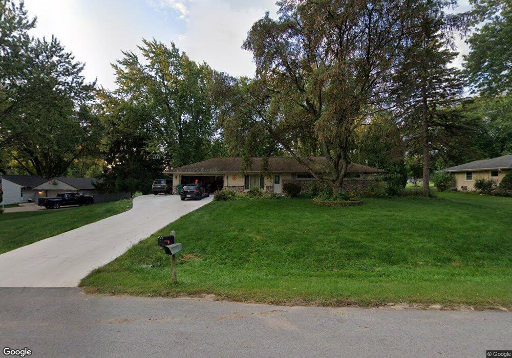
N79W16005 Community Dr Menomonee Falls, WI 53051
Estimated Value: $335,000 - $366,216
3
Beds
1
Bath
1,104
Sq Ft
$317/Sq Ft
Est. Value
About This Home
This home is located at N79W16005 Community Dr, Menomonee Falls, WI 53051 and is currently estimated at $349,554, approximately $316 per square foot. N79W16005 Community Dr is a home located in Waukesha County with nearby schools including Valley View Elementary School, North Middle School, and Menomonee Falls High School.
Ownership History
Date
Name
Owned For
Owner Type
Purchase Details
Closed on
Feb 23, 2012
Sold by
Springleaf Financial Services Of Wiscons
Bought by
Strehlow Mark A and Krage Crystal J
Current Estimated Value
Home Financials for this Owner
Home Financials are based on the most recent Mortgage that was taken out on this home.
Original Mortgage
$142,500
Outstanding Balance
$97,627
Interest Rate
3.89%
Mortgage Type
New Conventional
Estimated Equity
$251,927
Purchase Details
Closed on
Dec 6, 2010
Sold by
Kiepert Sallyann E
Bought by
American General Financial Services Of W
Purchase Details
Closed on
Mar 17, 2005
Sold by
Kiepert Robert W and Kiepert Sally Ann E
Bought by
Kiepert Sally Ann E
Home Financials for this Owner
Home Financials are based on the most recent Mortgage that was taken out on this home.
Original Mortgage
$80,000
Interest Rate
5.64%
Mortgage Type
Future Advance Clause Open End Mortgage
Create a Home Valuation Report for This Property
The Home Valuation Report is an in-depth analysis detailing your home's value as well as a comparison with similar homes in the area
Home Values in the Area
Average Home Value in this Area
Purchase History
| Date | Buyer | Sale Price | Title Company |
|---|---|---|---|
| Strehlow Mark A | $150,000 | None Available | |
| American General Financial Services Of W | -- | None Available | |
| Kiepert Sally Ann E | -- | -- |
Source: Public Records
Mortgage History
| Date | Status | Borrower | Loan Amount |
|---|---|---|---|
| Open | Strehlow Mark A | $142,500 | |
| Previous Owner | Kiepert Sally Ann E | $80,000 |
Source: Public Records
Tax History Compared to Growth
Tax History
| Year | Tax Paid | Tax Assessment Tax Assessment Total Assessment is a certain percentage of the fair market value that is determined by local assessors to be the total taxable value of land and additions on the property. | Land | Improvement |
|---|---|---|---|---|
| 2024 | $3,459 | $308,700 | $115,200 | $193,500 |
| 2023 | $3,321 | $308,700 | $115,200 | $193,500 |
| 2022 | $3,176 | $199,400 | $79,200 | $120,200 |
| 2021 | $3,037 | $199,400 | $79,200 | $120,200 |
| 2020 | $3,206 | $199,400 | $79,200 | $120,200 |
| 2019 | $3,062 | $199,400 | $79,200 | $120,200 |
| 2018 | $3,205 | $199,400 | $79,200 | $120,200 |
| 2017 | $3,328 | $199,400 | $79,200 | $120,200 |
| 2016 | $3,383 | $199,400 | $79,200 | $120,200 |
| 2015 | $3,397 | $199,400 | $79,200 | $120,200 |
| 2014 | $3,623 | $199,400 | $79,200 | $120,200 |
| 2013 | $3,623 | $199,400 | $79,200 | $120,200 |
Source: Public Records
Map
Nearby Homes
- N53W19764 Kingair Dr
- N53W19776 Kingair Dr
- W155N7481 Pebble Ct
- N84W15750 Ridge Rd Unit 204
- W163N8459 Arthur Ave
- W147N7725 Northpoint Dr
- N84W16544 Ann Ave
- N79W17331 Bluejay Ct Unit 1
- W148N7497 Woodland Dr
- N76W14595 N Point Ct
- N86W16193 Arthur Ave
- W174N8125 Shady Ln Unit 1
- W175N8080 Robin Cir Unit 1
- N86W16387 Appleton Ave
- W148N7311 Woodland Dr
- N86W16564 Jacobson Dr
- N72W17011 Good Hope Rd
- Lt2 Good Hope Rd
- The Charlotte Plan at Edgewood Preserve
- The Elsa Plan at Edgewood Preserve
- N79W16043 Community Dr
- N79W15971 Community Dr
- N79W16004 Community Dr
- N79W16042 Community Dr
- W159N7885 Bradley Cir
- N79W15970 Community Dr
- N79W16079 Community Dr
- N78W15984 Carl Ross Dr
- N78W16024 Carl Ross Dr
- N79W16078 Community Dr
- N79W15930 Community Dr
- N79W16119 Community Dr
- N78W16060 Carl Ross Dr
- N78W15940 Carl Ross Dr
- N79W16118 Community Dr
- N78W16094 Carl Ross Dr
- W159N7900 Bradley Cir
- W158N7861 Bradley Cir
- N79W15997 Longwood St
- N79W16031 Longwood St