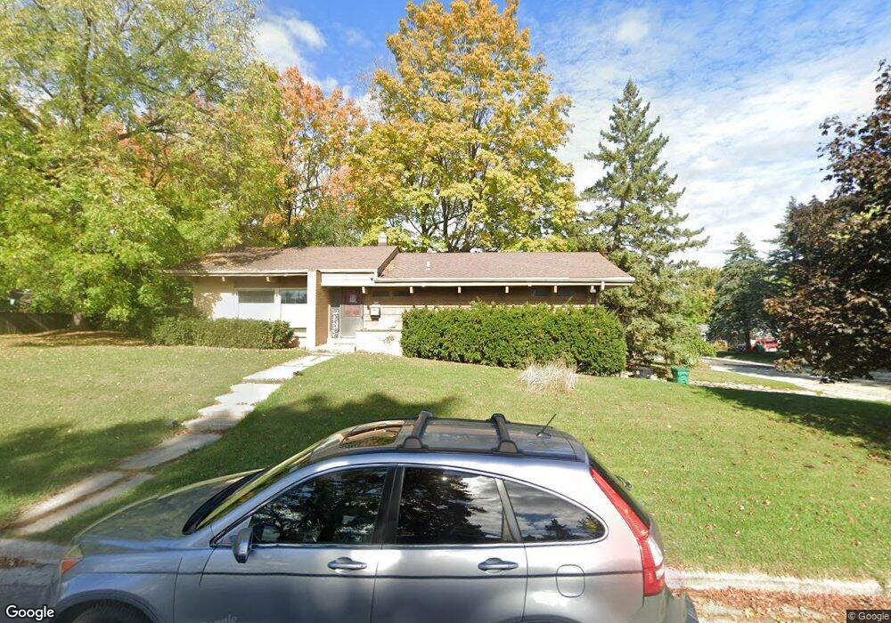
N92W17040 Forest Dr Menomonee Falls, WI 53051
Estimated Value: $277,000 - $360,214
3
Beds
2
Baths
1,320
Sq Ft
$255/Sq Ft
Est. Value
About This Home
This home is located at N92W17040 Forest Dr, Menomonee Falls, WI 53051 and is currently estimated at $336,804, approximately $255 per square foot. N92W17040 Forest Dr is a home located in Waukesha County with nearby schools including Shady Lane Elementary School, North Middle School, and Menomonee Falls High School.
Ownership History
Date
Name
Owned For
Owner Type
Purchase Details
Closed on
Jun 29, 2015
Sold by
Citimortgage Inc
Bought by
Frye Harold and Frye Kezza
Current Estimated Value
Home Financials for this Owner
Home Financials are based on the most recent Mortgage that was taken out on this home.
Original Mortgage
$114,400
Interest Rate
4.01%
Mortgage Type
New Conventional
Purchase Details
Closed on
Feb 23, 2015
Sold by
Estate Of Richard D Wojtanowski
Bought by
Citimortgage Inc
Purchase Details
Closed on
Feb 21, 2003
Sold by
Umbreit Gary L and Schiedemeyer Diane
Bought by
Wojtanowski Richard G
Home Financials for this Owner
Home Financials are based on the most recent Mortgage that was taken out on this home.
Original Mortgage
$157,044
Interest Rate
6%
Mortgage Type
Purchase Money Mortgage
Create a Home Valuation Report for This Property
The Home Valuation Report is an in-depth analysis detailing your home's value as well as a comparison with similar homes in the area
Home Values in the Area
Average Home Value in this Area
Purchase History
| Date | Buyer | Sale Price | Title Company |
|---|---|---|---|
| Frye Harold | $143,000 | None Available | |
| Citimortgage Inc | $148,443 | None Available | |
| Wojtanowski Richard G | $172,000 | -- |
Source: Public Records
Mortgage History
| Date | Status | Borrower | Loan Amount |
|---|---|---|---|
| Previous Owner | Frye Harold | $114,400 | |
| Previous Owner | Wojtanowski Richard G | $157,044 |
Source: Public Records
Tax History Compared to Growth
Tax History
| Year | Tax Paid | Tax Assessment Tax Assessment Total Assessment is a certain percentage of the fair market value that is determined by local assessors to be the total taxable value of land and additions on the property. | Land | Improvement |
|---|---|---|---|---|
| 2024 | $3,488 | $293,200 | $92,300 | $200,900 |
| 2023 | $3,380 | $293,200 | $92,300 | $200,900 |
| 2022 | $3,384 | $198,900 | $63,700 | $135,200 |
| 2021 | $3,248 | $198,900 | $63,700 | $135,200 |
| 2020 | $3,362 | $198,900 | $63,700 | $135,200 |
| 2019 | $3,239 | $198,900 | $63,700 | $135,200 |
| 2018 | $3,513 | $198,900 | $63,700 | $135,200 |
| 2017 | $3,401 | $195,900 | $63,700 | $132,200 |
| 2016 | $3,469 | $195,900 | $63,700 | $132,200 |
| 2015 | $3,457 | $195,900 | $63,700 | $132,200 |
| 2014 | -- | $195,900 | $63,700 | $132,200 |
| 2013 | -- | $195,900 | $63,700 | $132,200 |
Source: Public Records
Map
Nearby Homes
- N92W17274 Forest Dr
- W174N9287 Joper Rd
- N90W16995 Appleton Ave
- W166N9108 Grand Ave
- N94W17842 Appleton Ave
- N89W16328 Cleveland Ave
- W160N8969 Madison Ave
- N88W17690 Christman Rd
- W178N8846 Queensway St
- W162N9761 Mayflower Dr
- N88W17868 Christman Rd
- W179N9765 Riversbend Cir W
- N99W16701 Woodcock Rd
- N86W16387 Appleton Ave
- N99W17909 Appletree Ct Unit D-102
- W177N8635 Lynwood Dr
- N86W16193 Arthur Ave
- N98W15894 Concord Rd
- Lt101 Main St
- Lt54 Main St
- N92W17072 Forest Dr
- N92W17053 Forest Dr
- W170N9289 Woodlawn Dr
- W171N9288 Briarwood Terrace
- N92W17075 Forest Dr
- N92W17033 Forest Dr
- N92W17013 Forest Dr
- W171N9300 Briarwood Terrace
- W170N9282 Woodlawn Dr
- N92W17095 Forest Dr
- W170N9311 Woodlawn Dr
- N92W16991 Forest Dr
- W171N9312 Briarwood Terrace
- N92W17115 Forest Dr
- W171N9289 Briarwood Terrace
- N92W17128 Forest Dr
- W170N9296 Woodlawn Dr
- N92W17052 Roger Ave
- N92W16970 Forest Dr
- N92W17072 Roger Ave