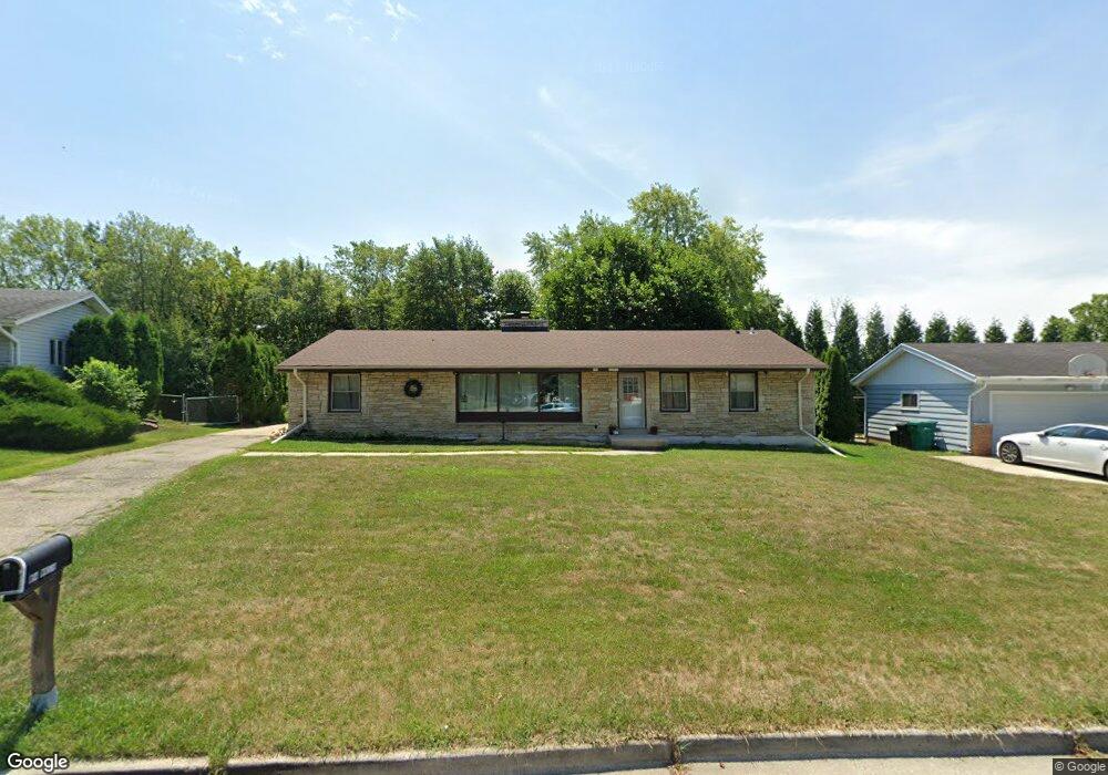
N94W16539 Cumberland Rd Menomonee Falls, WI 53051
Estimated Value: $372,000 - $423,734
3
Beds
2
Baths
1,990
Sq Ft
$203/Sq Ft
Est. Value
About This Home
This home is located at N94W16539 Cumberland Rd, Menomonee Falls, WI 53051 and is currently estimated at $403,934, approximately $202 per square foot. N94W16539 Cumberland Rd is a home located in Waukesha County with nearby schools including Shady Lane Elementary School, North Middle School, and Menomonee Falls High School.
Ownership History
Date
Name
Owned For
Owner Type
Purchase Details
Closed on
Jun 14, 2017
Sold by
Larrys House Llc
Bought by
Leazer Tyrone and Leazer Sara
Current Estimated Value
Home Financials for this Owner
Home Financials are based on the most recent Mortgage that was taken out on this home.
Original Mortgage
$212,087
Outstanding Balance
$178,681
Interest Rate
4.5%
Mortgage Type
FHA
Estimated Equity
$225,253
Purchase Details
Closed on
Jul 2, 2015
Sold by
Trott Joseph D
Bought by
Larrys House Llc
Purchase Details
Closed on
Mar 25, 1996
Sold by
Trott Janet L
Bought by
Trott Joseph M
Home Financials for this Owner
Home Financials are based on the most recent Mortgage that was taken out on this home.
Original Mortgage
$70,000
Interest Rate
6.98%
Create a Home Valuation Report for This Property
The Home Valuation Report is an in-depth analysis detailing your home's value as well as a comparison with similar homes in the area
Home Values in the Area
Average Home Value in this Area
Purchase History
| Date | Buyer | Sale Price | Title Company |
|---|---|---|---|
| Leazer Tyrone | $216,000 | None Available | |
| Larrys House Llc | $105,000 | None Available | |
| Trott Joseph M | -- | -- |
Source: Public Records
Mortgage History
| Date | Status | Borrower | Loan Amount |
|---|---|---|---|
| Open | Leazer Tyrone | $212,087 | |
| Previous Owner | Trott Joseph M | $70,000 |
Source: Public Records
Tax History Compared to Growth
Tax History
| Year | Tax Paid | Tax Assessment Tax Assessment Total Assessment is a certain percentage of the fair market value that is determined by local assessors to be the total taxable value of land and additions on the property. | Land | Improvement |
|---|---|---|---|---|
| 2024 | $5,145 | $326,700 | $92,100 | $234,600 |
| 2023 | $3,754 | $326,700 | $92,100 | $234,600 |
| 2022 | $3,625 | $213,500 | $63,400 | $150,100 |
| 2021 | $4,907 | $213,500 | $63,400 | $150,100 |
| 2020 | $5,588 | $213,500 | $63,400 | $150,100 |
| 2019 | $4,293 | $213,500 | $63,400 | $150,100 |
| 2018 | $3,623 | $213,500 | $63,400 | $150,100 |
| 2017 | $3,705 | $213,500 | $63,400 | $150,100 |
| 2016 | $3,779 | $213,500 | $63,400 | $150,100 |
| 2015 | $4,912 | $204,600 | $63,400 | $141,200 |
| 2014 | $3,719 | $204,600 | $63,400 | $141,200 |
| 2013 | $3,719 | $204,600 | $63,400 | $141,200 |
Source: Public Records
Map
Nearby Homes
- N92W17274 Forest Dr
- N89W16328 Cleveland Ave
- N90W16995 Appleton Ave
- W174N9287 Joper Rd
- N99W16701 Woodcock Rd
- N98W15894 Concord Rd
- N55W20134 Magnolia Ln
- W176N9734 Riversbend Cir E
- W176N9746 Riversbend Cir E Unit E
- N94W17842 Appleton Ave
- Lt101 Main St
- Lt54 Main St
- Lt8 Main St
- Lt53 Main St
- Lt57 Main St
- Lt13 Main St
- Lt87 Main St
- Lt45 Main St
- Lt38 Main St
- Lt42 Main St
- N94W16561 Cumberland Rd
- N94W16519 Cumberland Rd
- N94W16538 Cumberland Rd
- N94W16581 Cumberland Rd
- N94W16497 Cumberland Rd
- W165N9476 Lexington Dr
- N94W16504 Cumberland Rd
- N94W16603 Cumberland Rd
- W165N9490 Lexington Dr
- N94W16473 Cumberland Rd
- N94W16478 Cumberland Rd
- W165N9500 Lexington Dr
- N94W16625 Cumberland Rd
- N94W16452 Cumberland Rd
- W165N9481 Lexington Dr
- W165N9508 Lexington Dr
- W164N9449 Water St
- W164N9423 Water St
- W165N9487 Lexington Dr
- W164N9441 Water St