NOT LISTED FOR SALE

Nhn Labrant Ridge Rd Kalispell, MT 59901

Estimated Value: $670,000 - $1,904,456

20 Acres
$63,978 Price per Acre
876,427 Sq Ft Lot

Last Sold March 14, 2014

Current estimated payment $7,686/month

519 Days on Market

Highlights

  • Views of Trees
  • Waterfront
  • Level Lot

About This Lot

As of March 2014

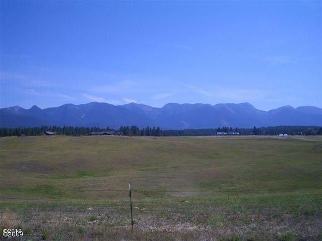
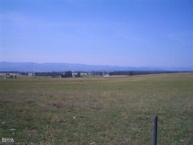
Remarks: Motivated Sellers!!! In your face 360 degree views of the Swan Range to the East and Lower Valley to the West. Bring your horses and build your dream home with acreage to spare.

Last Listed By

Carson Smith

Whitetail Properties Real Estate License #RRE-RBS-LIC-14541 Listed on: 08/09/2012

Whitetail Properties Real Estate

Property Details

Property Type

  • Land

Est. Annual Taxes

  • $6,585

Year Built

  • 2014

Lot Details

  • 20.12 Acre Lot
  • Waterfront
  • Property fronts a county road
  • Level Lot
  • Few Trees
  • Zoning described as Ag-20

Property Views

  • Trees
  • Mountain
  • Valley

Utilities

  • Well

Listing and Financial Details

  • Assessor Parcel Number 07396726203070000

Property Details

Property Type

Land

Est. Annual Taxes

$6,585

Year Built

2014

Lot Details

0

Listing Details

  • Property Sub Type: Residential
  • Property Type: Land
  • Directions: Highway 35 to La Brant Road. First left on to La Brant Ridge. Property is on left
  • Listing I D: 314894
  • Road Frontage Type: Waterfront
  • Lot Size Acres: 20.12
  • Lot Size: 20.12
  • Road Frontage Type: County Road
  • Road Surface Type: Gravel
  • Water Body Name: n/a
  • Property Sub Type Additional: Residential
  • Special Features: None
  • Year Built (Public Record): 2014

Exterior Features

  • Fencing: Barbed Wire
  • Lot Features: Few Trees, Level
  • Topography: Level,Sloping
  • View: Mountain(s), Valley, Trees/Woods
  • View: Yes
  • Waterfront Features: None
  • Waterfront: No

Utilities

  • Water Source: Well

Lot Info

  • Lot Size Sq Ft: 876427.2
  • Parcel #: 07396726203070000
  • Zoning Description: Ag-20
  • ResoLotSizeUnits: Acres

Tax Info

  • Tax Year: 2013
  • Tax Annual Amount: 32.48

Ownership History

Date Name Owned For Owner Type

Purchase Details

Closed on
Jan 6, 2023
Sold by
Grende Jason D
Bought by
Jordan T Selmanson Irrevocable Trust
Total Days on Market
519
Current Estimated Value
$1,287,228

Purchase Details

Listed on
Aug 9, 2012
Closed on
Mar 13, 2014
Sold by
Marshall Wendy A and Marshall Nicholas R
Bought by
Grende Jason D and Grende Jami J
Seller's Agent
Carson Smith
Whitetail Properties Real Estate
Buyer's Agent
Larry Wakefield
NextHome Northwest Real Estate
List Price
$270,000
Sold Price
$177,500
Premium/Discount to List
-$92,500
-34.26%

Home Financials for this Owner

Home Financials are based on the most recent Mortgage that was taken out on this home.
Avg. Annual Appreciation
22.41%

Purchase Details

Closed on
Oct 2, 2008
Sold by
Marshall Nick R and Marshall Wendy
Bought by
Marshall Wendy A and Marshall Nicholas R

Range of Values:

Collateral Analytics

Collateral Analytics Collateral Analytics AVMs (Automated Valuation Model) employ a number of statistical approaches combined with neighborhood-specific comparable selection guarantees the most up-to-date and precise valuations.

Not Available

Collateral Analytics does not have data for the current month. Please view the chart for historical values.

ICE

ICE Mortgage Technology ICE Mortgage Technology’s AVM (Automated Valuation Model) is a state-of-the-art online residential property valuation tool that provides a quick and accurate estimate of the value of almost any home in the U.S.

Not Available

ICE Mortgage Technology does not have data for the current month. Please view the chart for historical values.

First American

First American First American Data & Analytics’ next-generation AVM combines unrivaled data assets with a blended ensemble of valuation models to produce highly accurate, reliable valuations you can trust.

Not Available

First American does not have data for the current month. Please view the chart for historical values.

Quantarium

Quantarium Quantarium’s valuation service, repeatedly proven the industry’s most accurate and comprehensive, is supercharged with a self-learning and auto-tuning AI engine that continually becomes smarter and more accurate as it processes daily inputs from the industry’s leading RE data lake.

Not Available

Quantarium does not have data for the current month. Please view the chart for historical values.

Average Value
Not Available
List Price
Sold Price
Create a Home Valuation Report for This Property
The Home Valuation Report is an in-depth analysis detailing your home's value as well as a comparison with similar homes in the area

Similar Property in Kalispell, MT

  • 5464 Mt Highway 35, Kalispell, MT 59901

    $1,025,000

    • Land
    • 18 Acres
    • $58,107 per Acre
    • 5464 Mt Highway 35
    • Kalispell, MT

    RARE OPPORTUNITY on MT Highway 35! Nestled between Kalispell, Bigfork, and Columbia Falls, this property is listed below market value per acre! With two entrances off Hwy 35 and a 5%+ annual cap rate, it boasts incredible development potential, offering options for minor subdivision, major subdivision, and family transfer subdividing, along with all utilities already connected and generating

    Rachel Fedor Ideal Real Estate

    Section Image

Home Values in the Area

Source: Public Records

Average Home Value in this Area


Source: Public Records

Purchase History

Date Buyer Sale Price Title Company
Jordan T Selmanson Irrevocable Trust -- Fidelity National Title
Grende Jason D -- Insured Titles
Marshall Wendy A -- None Available
Source: Public Records

Mortgage History

Date Status Borrower Loan Amount
Previous Owner Grende Jason D $376,200
Previous Owner Grende Jason D $412,000
Previous Owner Grende Jason D $400,000
Source: Public Records

Property History

Date Event Price Change Sq Ft Price
03/14/2014 03/14/14 Sold -- -- --
01/10/2014 01/10/14 Pending -- -- --
08/09/2012 08/09/12 For Sale $270,000 -- --
Source: Montana Regional MLS

Tax History Compared to Growth

Source: Public Records

Tax History

Year Tax Paid Tax Assessment Tax Assessment Total Assessment is a certain percentage of the fair market value that is determined by local assessors to be the total taxable value of land and additions on the property. Land Improvement
2024 $6,585 $1,358,423 $0 $0
2023 $6,296 $1,293,983 $0 $0
2022 $6,706 $989,168 $0 $0
2021 $7,101 $989,168 $0 $0
2020 $6,571 $889,135 $0 $0
2019 $6,307 $889,135 $0 $0
2018 $5,833 $778,120 $0 $0
2017 $5,531 $778,120 $0 $0
2016 $5,349 $725,441 $0 $0
2015 $4,960 $725,441 $0 $0
2014 $33 $777 $0 $0
Source: Public Records

Agents Affiliated with this Home

  • Section Image
  • Section Image
See All Agents

Map

Source: Montana Regional MLS

MLS Number: 314894

Montana Regional MLS

APN: 07-3967-26-2-03-07-0000