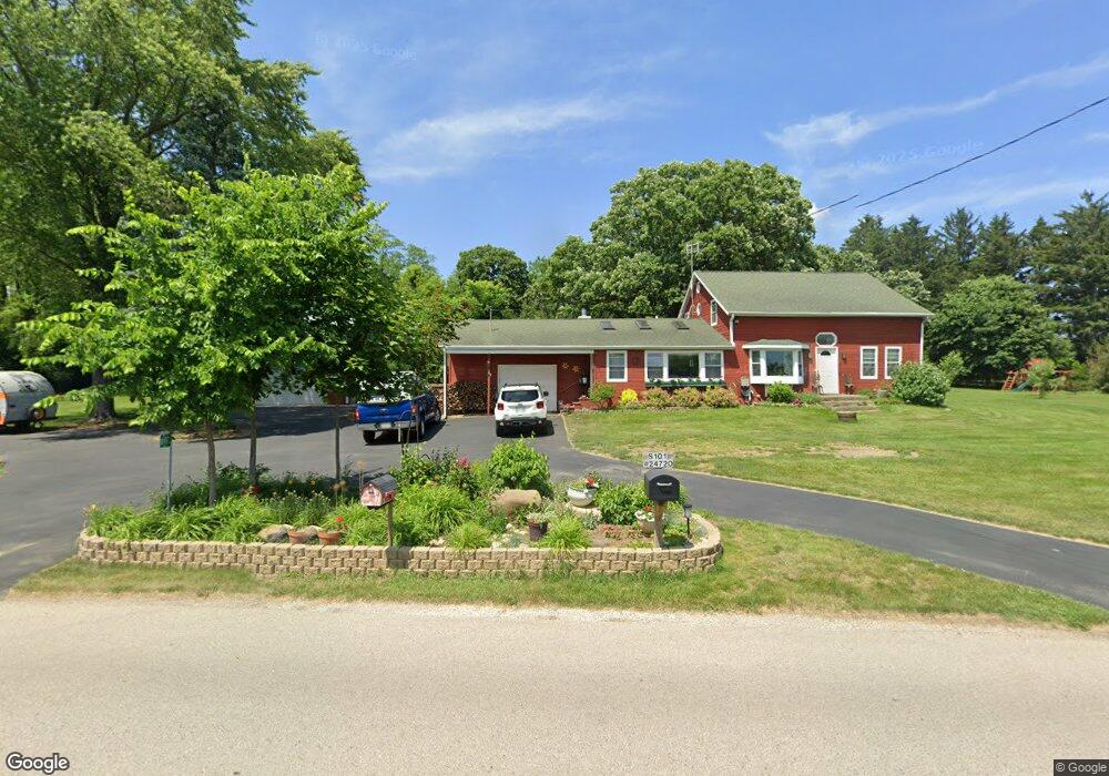
S101W24800 Maple Ave Mukwonago, WI 53149
Estimated Value: $389,000 - $433,000
--
Bed
--
Bath
--
Sq Ft
1.42
Acres
About This Home
This home is located at S101W24800 Maple Ave, Mukwonago, WI 53149 and is currently estimated at $403,205. S101W24800 Maple Ave is a home located in Waukesha County with nearby schools including Big Bend Elementary School, Park View Middle School, and Mukwonago High School.
Ownership History
Date
Name
Owned For
Owner Type
Purchase Details
Closed on
Mar 24, 2025
Sold by
Largen Nicholas
Bought by
Largen Nicholas and Largen Samantha
Current Estimated Value
Home Financials for this Owner
Home Financials are based on the most recent Mortgage that was taken out on this home.
Original Mortgage
$361,700
Outstanding Balance
$359,775
Interest Rate
6.67%
Mortgage Type
New Conventional
Estimated Equity
$43,430
Purchase Details
Closed on
Nov 20, 2018
Sold by
Urlbe Shirley and Urlbe Shirley Ann
Bought by
Largen Nicholas
Home Financials for this Owner
Home Financials are based on the most recent Mortgage that was taken out on this home.
Original Mortgage
$208,000
Interest Rate
4.9%
Mortgage Type
VA
Create a Home Valuation Report for This Property
The Home Valuation Report is an in-depth analysis detailing your home's value as well as a comparison with similar homes in the area
Home Values in the Area
Average Home Value in this Area
Purchase History
| Date | Buyer | Sale Price | Title Company |
|---|---|---|---|
| Largen Nicholas | -- | None Listed On Document | |
| Largen Nicholas | -- | None Available |
Source: Public Records
Mortgage History
| Date | Status | Borrower | Loan Amount |
|---|---|---|---|
| Open | Largen Nicholas | $361,700 | |
| Previous Owner | Largen Nicholas | $208,000 |
Source: Public Records
Tax History Compared to Growth
Tax History
| Year | Tax Paid | Tax Assessment Tax Assessment Total Assessment is a certain percentage of the fair market value that is determined by local assessors to be the total taxable value of land and additions on the property. | Land | Improvement |
|---|---|---|---|---|
| 2024 | $2,432 | $300,800 | $116,900 | $183,900 |
| 2023 | $2,346 | $300,800 | $116,900 | $183,900 |
| 2022 | $2,416 | $220,800 | $81,500 | $139,300 |
| 2021 | $2,377 | $220,800 | $81,500 | $139,300 |
| 2020 | $2,435 | $220,800 | $81,500 | $139,300 |
| 2019 | $2,245 | $183,200 | $73,700 | $109,500 |
| 2018 | $2,264 | $183,200 | $73,700 | $109,500 |
| 2017 | $2,561 | $183,200 | $73,700 | $109,500 |
| 2016 | $2,242 | $183,200 | $73,700 | $109,500 |
| 2015 | $2,211 | $183,200 | $73,700 | $109,500 |
| 2014 | $2,352 | $0 | $0 | $0 |
| 2013 | $2,352 | $186,900 | $76,000 | $110,900 |
Source: Public Records
Map
Nearby Homes
- W240S10240 Castle Rd
- S94W23620 Kunzendorf Ct
- 8428 Fox River Rd
- W255S8545 Hi lo Dr
- S95W23000 River Oaks Dr
- S96W22870 River Oaks Dr
- 7908 Fox River Rd
- 7820 Fox River Rd
- Pcl0 Clark St
- W232S8755 Edgewood Ct
- 1625 Grey Fox Trail Unit F
- 1617 Grey Fox Trail Unit C
- 1629 Grey Fox Trail Unit B
- 1629 Grey Fox Trail Unit C
- 1629 Grey Fox Trail Unit D
- 1633 Grey Fox Trail Unit E
- 1725 Cardinal Ct
- 1730 Cardinal Ct
- 1760 Cardinal Ct
- 915 Cardinal Ln
- S101W24980 Maple Ave
- S101W25360 Maple Ave
- S103W24870 County Road L
- S101W24775 Maple Ave
- S101W25390 Maple Ave
- S109W25800 County Road L
- S109W25860 County Road L
- S108W25680 County Road L
- S108W25735 County Road L
- S101W24630 Forest Home Ave
- S101W25450 Maple Ave
- S101W24760 Maple Ave
- S101W24830 Maple Ave
- S101W24720 Maple Ave
- S101W24700 Maple Ave
- S101W25545 Maple Ave
- W256S10160 Sandhill Ridge
- W256S10220 Sandhill Ridge
- W256S10330 Sandhill Ridge
- W256S10240 Sandhill Ridge