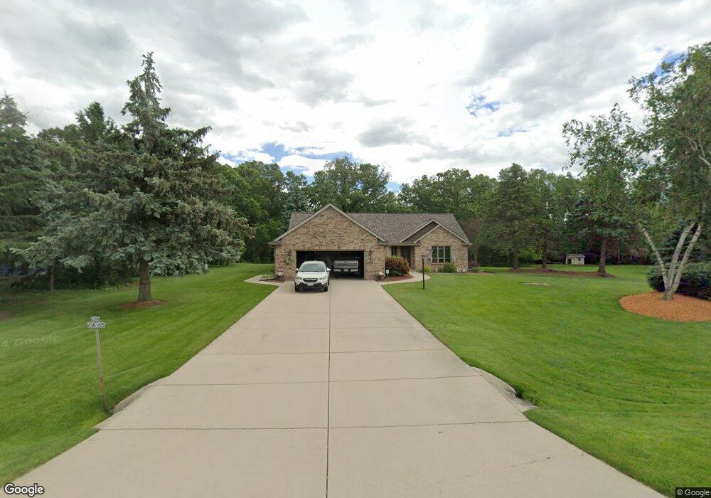
S28W36105 Scuppernong Cir Dousman, WI 53118
Estimated Value: $495,229 - $668,000
--
Bed
--
Bath
--
Sq Ft
1.51
Acres
About This Home
This home is located at S28W36105 Scuppernong Cir, Dousman, WI 53118 and is currently estimated at $597,057. S28W36105 Scuppernong Cir is a home located in Waukesha County with nearby schools including Dousman Elementary School, Kettle Moraine Middle School, and Kettle Moraine High School.
Ownership History
Date
Name
Owned For
Owner Type
Purchase Details
Closed on
May 16, 2003
Sold by
Lilly Patrick A and Lilly Linda A
Bought by
Zaborski Dann P and Hartwig Pamela A
Current Estimated Value
Home Financials for this Owner
Home Financials are based on the most recent Mortgage that was taken out on this home.
Original Mortgage
$100,000
Interest Rate
5.88%
Mortgage Type
Purchase Money Mortgage
Create a Home Valuation Report for This Property
The Home Valuation Report is an in-depth analysis detailing your home's value as well as a comparison with similar homes in the area
Home Values in the Area
Average Home Value in this Area
Purchase History
| Date | Buyer | Sale Price | Title Company |
|---|---|---|---|
| Zaborski Dann P | $300,000 | -- |
Source: Public Records
Mortgage History
| Date | Status | Borrower | Loan Amount |
|---|---|---|---|
| Closed | Zaborski Dann P | $100,000 |
Source: Public Records
Tax History Compared to Growth
Tax History
| Year | Tax Paid | Tax Assessment Tax Assessment Total Assessment is a certain percentage of the fair market value that is determined by local assessors to be the total taxable value of land and additions on the property. | Land | Improvement |
|---|---|---|---|---|
| 2024 | $4,068 | $456,000 | $174,000 | $282,000 |
| 2023 | $3,890 | $451,000 | $169,000 | $282,000 |
| 2022 | $4,261 | $415,000 | $163,000 | $252,000 |
| 2021 | $3,376 | $287,000 | $104,000 | $183,000 |
| 2020 | $3,735 | $287,000 | $104,000 | $183,000 |
| 2019 | $3,518 | $287,000 | $104,000 | $183,000 |
| 2018 | $3,447 | $287,000 | $104,000 | $183,000 |
| 2017 | $3,477 | $287,000 | $104,000 | $183,000 |
| 2016 | $3,385 | $287,000 | $104,000 | $183,000 |
| 2015 | $3,395 | $287,000 | $104,000 | $183,000 |
| 2014 | $3,757 | $287,000 | $104,000 | $183,000 |
| 2013 | $3,757 | $287,000 | $104,000 | $183,000 |
Source: Public Records
Map
Nearby Homes
- W361S2389 Scuppernong Dr
- Lt2 Mill Pond Rd
- 856 S Mill Pond Rd
- S26W35135 Woodstream Ct
- 460 E Red Pine Cir
- Lt1 E Ottawa Ave
- N62W35431 William Ct
- S31W37307 School Section Lake Rd
- 148 Wolf Dr
- Lt8 Wolf Dr
- Lt7 Wolf Dr
- Lt6 Wolf Dr
- Lt5 Wolf Dr
- Lt4 Wolf Dr
- Lt2 Wolf Dr
- 412 Sand Hill Ln
- 109 Johnston Dr Unit 111
- 144 Evergreen St
- Lt50 W Ingleside Ct
- Pcl2 County Road z
- W360S2882 Scuppernong Dr
- S28W36115 Scuppernong Cir
- S28W36106 Scuppernong Cir
- W360S2873 Scuppernong Dr
- S28W36123 Scuppernong Cir
- W360S2872 Scuppernong Dr
- S28W36124 Scuppernong Cir
- S28W36127 Scuppernong Cir
- W360S2850 Scuppernong Dr
- W360S2881 State Road 67
- S28W36085 Scuppernong Cir
- S28W36134 Scuppernong Cir
- S27W36117 Scuppernong Cir
- S28W36169 Scuppernong Cir
- W360S2899 State Road 67
- W360S2834 Scuppernong Dr
- S27W36153 Scuppernong Cir
- W360S2801 Scuppernong Dr
- S28W36203 Scuppernong Cir
- S27W36201 Scuppernong Cir