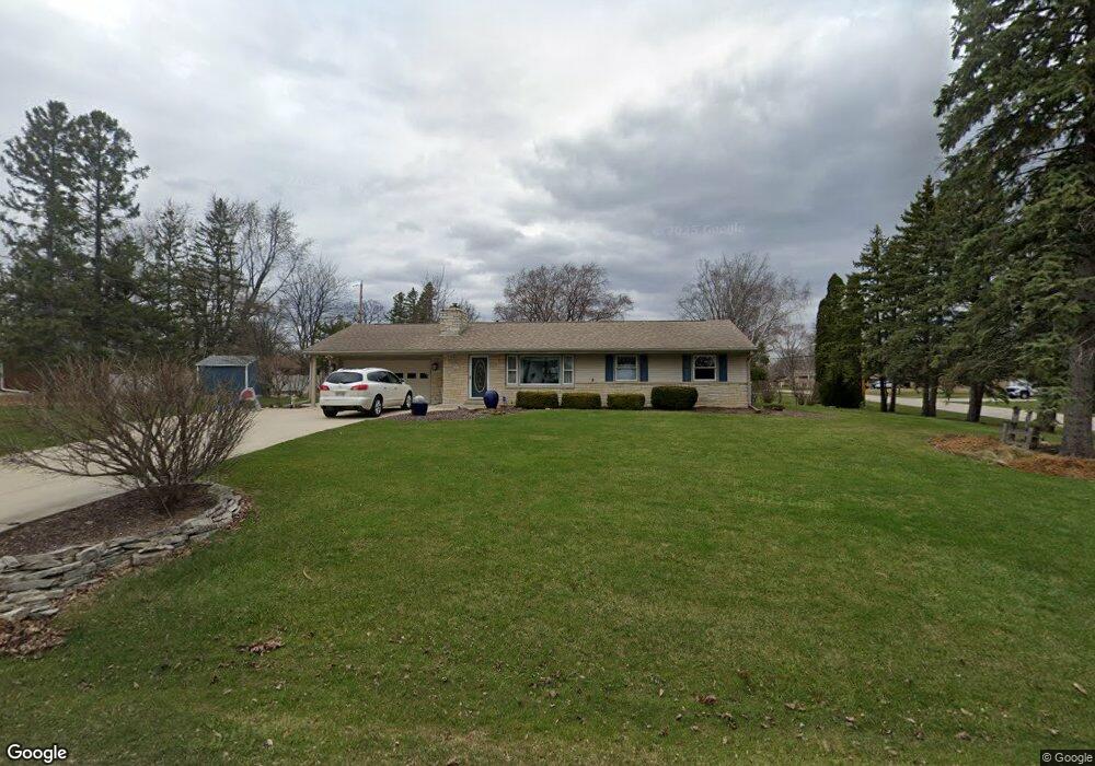
S65W12512 Byron Rd Muskego, WI 53150
Estimated Value: $394,410 - $433,000
3
Beds
2
Baths
1,283
Sq Ft
$315/Sq Ft
Est. Value
About This Home
This home is located at S65W12512 Byron Rd, Muskego, WI 53150 and is currently estimated at $404,353, approximately $315 per square foot. S65W12512 Byron Rd is a home located in Waukesha County with nearby schools including Bay Lane Elementary School, Lake Denoon Middle School, and Creative and Performing Arts.
Create a Home Valuation Report for This Property
The Home Valuation Report is an in-depth analysis detailing your home's value as well as a comparison with similar homes in the area
Home Values in the Area
Average Home Value in this Area
Tax History Compared to Growth
Tax History
| Year | Tax Paid | Tax Assessment Tax Assessment Total Assessment is a certain percentage of the fair market value that is determined by local assessors to be the total taxable value of land and additions on the property. | Land | Improvement |
|---|---|---|---|---|
| 2024 | $3,003 | $267,800 | $69,500 | $198,300 |
| 2023 | $2,957 | $267,800 | $69,500 | $198,300 |
| 2022 | $2,893 | $267,800 | $69,500 | $198,300 |
| 2021 | $2,864 | $267,800 | $69,500 | $198,300 |
| 2020 | $2,997 | $219,300 | $60,800 | $158,500 |
| 2019 | $2,966 | $219,300 | $60,800 | $158,500 |
| 2018 | $3,003 | $219,300 | $60,800 | $158,500 |
| 2017 | $3,006 | $219,300 | $60,800 | $158,500 |
| 2016 | $3,075 | $199,500 | $58,200 | $141,300 |
| 2015 | $3,109 | $199,500 | $58,200 | $141,300 |
| 2014 | $3,385 | $199,500 | $58,200 | $141,300 |
| 2013 | $3,385 | $199,500 | $58,200 | $141,300 |
Source: Public Records
Map
Nearby Homes
- 6180 Preston Ln
- 11931 W Janesville Rd
- W137S6834 Dunstan Ct
- 11310 Haleco Ln
- 11216 Bridget Ln
- 5701 S 121st St
- Lt8 Twin Silos Ct
- Lt17 W Old Farm Rd
- W140S6982 Twin Silos Ct
- 6749 S Prairie Wood Ln
- 6741 S Prairie Wood Ln
- 7084 S Fieldstone Ct Unit 43
- 13615 W Deer Park Dr
- 11470 W Tess Creek St
- 10464 W Whitnall Edge Dr Unit 203
- 12230 W Grange Ave
- 11532 W Tess Creek St
- 11415 W Tess Creek St
- 11388 W Tess Creek St
- Lt10 Norbert Ct
- S65W12558 Byron Rd
- S65W12511 Byron Rd
- W124S6566 Hawthorne Rd
- W125S6538 Whittier Terrace
- S65W12551 Byron Rd
- W124S6541 Hawthorne Rd
- W124S6592 Hawthorne Rd
- W124S6629 Hawthorne Rd
- W124S6540 Hawthorne Rd
- W124S6519 Hawthorne Rd
- S65W12587 Byron Rd
- W125S6518 Whittier Terrace
- W124S6624 Hawthorne Rd
- S65W12636 Byron Rd
- W125S6543 Whittier Terrace
- W124S6516 Hawthorne Rd
- W125S6521 Whittier Terrace
- S66W12496 Somerset Dr
- W124S6491 Hawthorne Rd
- S66W12548 Somerset Dr