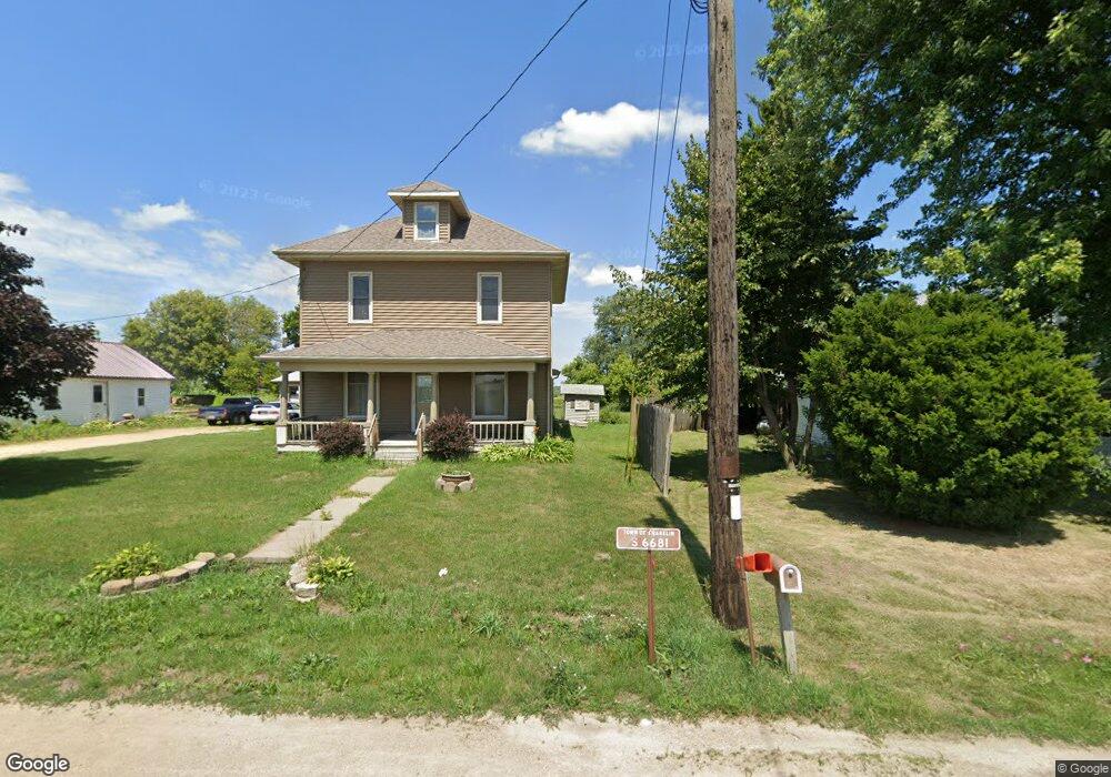
S6681 State Highway 82 Viroqua, WI 54665
Estimated Value: $193,000 - $340,000
--
Bed
--
Bath
--
Sq Ft
0.57
Acres
About This Home
This home is located at S6681 State Highway 82, Viroqua, WI 54665 and is currently estimated at $250,686. S6681 State Highway 82 is a home located in Vernon County with nearby schools including Viroqua Elementary School, Viroqua Middle School, and Viroqua High School.
Ownership History
Date
Name
Owned For
Owner Type
Purchase Details
Closed on
Jul 19, 2022
Sold by
Salisbury Angela M
Bought by
Buskohl Michaela E
Current Estimated Value
Purchase Details
Closed on
Oct 4, 2021
Sold by
Macfannie and Federal National Mortgage Asso
Bought by
Salisbury Angela M
Home Financials for this Owner
Home Financials are based on the most recent Mortgage that was taken out on this home.
Original Mortgage
$107,360
Interest Rate
2.8%
Mortgage Type
New Conventional
Purchase Details
Closed on
Jul 22, 2020
Sold by
Underwood Christopher L and Underwood Krista K
Bought by
Federal National Mortgage Association
Create a Home Valuation Report for This Property
The Home Valuation Report is an in-depth analysis detailing your home's value as well as a comparison with similar homes in the area
Home Values in the Area
Average Home Value in this Area
Purchase History
| Date | Buyer | Sale Price | Title Company |
|---|---|---|---|
| Buskohl Michaela E | $172,000 | Titleworks, Llc | |
| Salisbury Angela M | -- | None Available | |
| Federal National Mortgage Association | $86,700 | None Available |
Source: Public Records
Mortgage History
| Date | Status | Borrower | Loan Amount |
|---|---|---|---|
| Previous Owner | Salisbury Angela M | $107,360 |
Source: Public Records
Tax History Compared to Growth
Tax History
| Year | Tax Paid | Tax Assessment Tax Assessment Total Assessment is a certain percentage of the fair market value that is determined by local assessors to be the total taxable value of land and additions on the property. | Land | Improvement |
|---|---|---|---|---|
| 2024 | $2,783 | $130,800 | $9,100 | $121,700 |
| 2023 | $2,404 | $130,800 | $9,100 | $121,700 |
| 2022 | $2,229 | $130,800 | $9,100 | $121,700 |
| 2021 | $2,214 | $130,800 | $9,100 | $121,700 |
| 2020 | $2,083 | $130,800 | $9,100 | $121,700 |
| 2019 | $2,054 | $130,800 | $9,100 | $121,700 |
| 2018 | $2,048 | $130,800 | $9,100 | $121,700 |
| 2017 | $2,111 | $130,800 | $9,100 | $121,700 |
| 2016 | $2,114 | $130,800 | $9,100 | $121,700 |
| 2015 | $2,556 | $130,800 | $9,100 | $121,700 |
| 2014 | $2,168 | $130,800 | $9,100 | $121,700 |
| 2013 | $2,365 | $130,800 | $9,100 | $121,700 |
Source: Public Records
Map
Nearby Homes
- Lot 9 Woodland Rd
- LOT 15 16th Fairway Dr
- 1215 16th Fairway Dr
- 1213 16th Fairway Dr
- LOT 13 W Point Cir
- TBD Weber Rd
- LOT 28 16th Fairway Dr
- S5848 Cowden Rd
- LOT 30 16th Fairway Dr
- LOT 42 Crossing Meadows Dr
- LOT 41 Crossing Meadows Dr
- LOT 31 16th Fairway Dr
- Tbd Weber Rd
- 1129 16th Fairway Dr
- S5117 County Road Nn
- 807 S Main St
- 1 Sandy Oak Dr
- 727 Garfield Ave
- 208 Circle Dr S
- 720 S Main St
- S6681 State Highway 82 Unit S6681
- S6681 State Highway 82
- S661 Hwy 27 82
- S6681 State Highway 27 82
- S6685 State Highway 82
- S6677A State Highway 82
- s 6685 State Highway 82
- S6684 State Highway 82
- S6696 State Highway 82
- S6706 State Highway 27/82
- s 6705 State Highway 82
- S6705 State Highway 82
- S6755 State Highway 82
- S6773 State Highway 82
- E6795 Hornby Rd
- S6789 State Highway 82
- S6835 Highway 27
- E6905 Hinkst Hollow Rd
- E4421 State Highway 82
- E6662 Hornby Hollow Rd