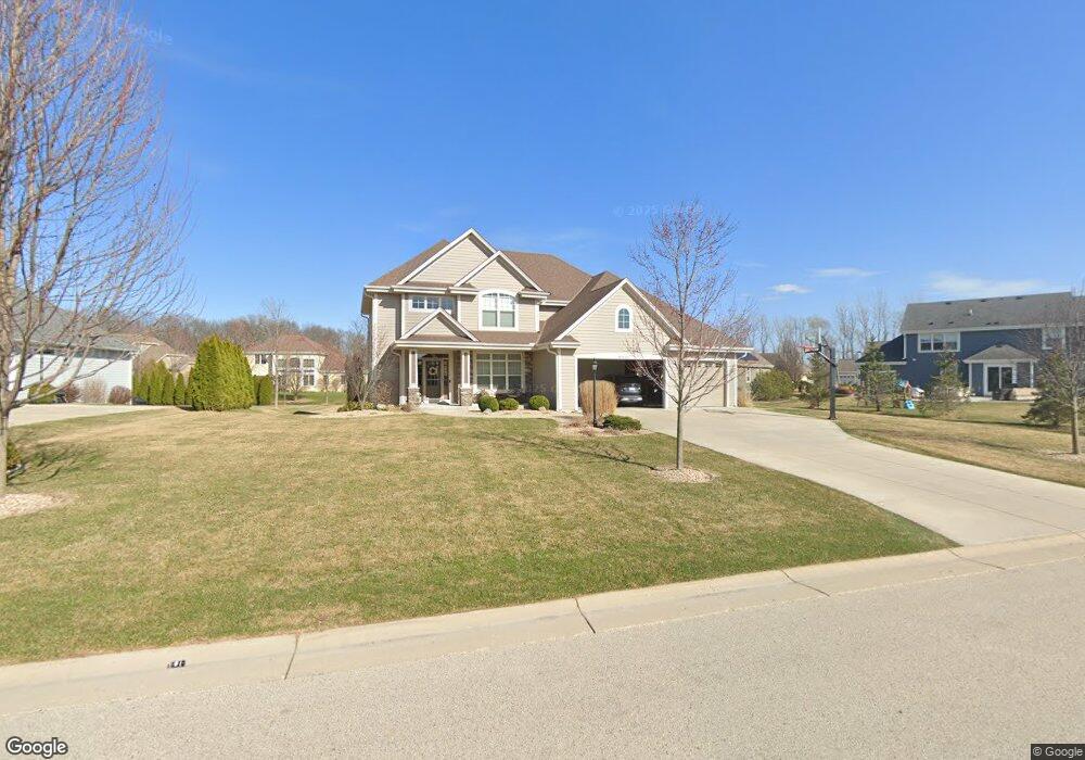
S77W15028 Pheasant Run Dr Muskego, WI 53150
Estimated Value: $736,000 - $804,000
--
Bed
--
Bath
--
Sq Ft
0.42
Acres
About This Home
This home is located at S77W15028 Pheasant Run Dr, Muskego, WI 53150 and is currently estimated at $762,155. S77W15028 Pheasant Run Dr is a home with nearby schools including Bay Lane Elementary School, Lake Denoon Middle School, and Muskego High School.
Ownership History
Date
Name
Owned For
Owner Type
Purchase Details
Closed on
Jun 19, 2015
Sold by
Mk Ss Llc
Bought by
Boinski Jeffrey S and Boinski Sheila K
Current Estimated Value
Home Financials for this Owner
Home Financials are based on the most recent Mortgage that was taken out on this home.
Original Mortgage
$47,000
Outstanding Balance
$36,788
Interest Rate
4.05%
Mortgage Type
Credit Line Revolving
Estimated Equity
$725,367
Create a Home Valuation Report for This Property
The Home Valuation Report is an in-depth analysis detailing your home's value as well as a comparison with similar homes in the area
Home Values in the Area
Average Home Value in this Area
Purchase History
| Date | Buyer | Sale Price | Title Company |
|---|---|---|---|
| Boinski Jeffrey S | $470,000 | Members Title Group Llc |
Source: Public Records
Mortgage History
| Date | Status | Borrower | Loan Amount |
|---|---|---|---|
| Open | Boinski Jeffrey S | $47,000 |
Source: Public Records
Tax History Compared to Growth
Tax History
| Year | Tax Paid | Tax Assessment Tax Assessment Total Assessment is a certain percentage of the fair market value that is determined by local assessors to be the total taxable value of land and additions on the property. | Land | Improvement |
|---|---|---|---|---|
| 2024 | $6,754 | $565,000 | $115,500 | $449,500 |
| 2023 | $6,543 | $550,200 | $115,500 | $434,700 |
| 2022 | $6,360 | $550,200 | $115,500 | $434,700 |
| 2021 | $6,307 | $548,300 | $115,500 | $432,800 |
| 2020 | $6,424 | $444,900 | $100,700 | $344,200 |
| 2019 | $6,422 | $444,900 | $100,700 | $344,200 |
| 2018 | $6,472 | $444,900 | $100,700 | $344,200 |
| 2017 | $6,394 | $444,900 | $100,700 | $344,200 |
| 2016 | $6,881 | $423,900 | $96,100 | $327,800 |
| 2015 | $3,404 | $210,800 | $96,100 | $114,700 |
Source: Public Records
Map
Nearby Homes
- W145S7644 Durham Dr
- N51W19119 Quietwood Dr
- S70W14845 Dartmouth Cir
- S70W14872 Dartmouth Cir
- W163S7358 Bay Lane Dr
- S78W16730 Spinnaker Dr
- Lt8 Twin Silos Ct
- W162S7043 Olive Cir Unit 22
- S75W16788 Jacob Ct Unit 12
- S67W14570 Gaulke Ct
- W170S7361 Parkland Dr Unit 13
- S76W12788 Cambridge Ct E
- W169S7219 Avon Ct
- S68W13611 Hale Park Cir
- S76W12739 Cambridge Ct E
- Lt4 Lannon Dr
- W171S7452 Lannon Dr
- S73W17268 Lake Dr
- Wilshire Prairie Plan at Mallard Reserve
- Winfield II Plan at Mallard Reserve
- s77w Pheasant Run Dr Unit S77W15071
- S77W15036 Pheasant Run Dr
- S78W14926 Belle Chasse Pkwy
- S78W14958 Belle Chasse Pkwy
- S77W15025 Pheasant Run Dr
- S77W15031 Pheasant Run Dr
- S77W15042 Pheasant Run Dr
- W148S7789 Broken Arrow Ct
- W148S7801 Broken Arrow Ct
- S77W15039 Pheasant Run Dr
- S78W15030 Belle Chasse Pkwy
- W148S7775 Broken Arrow Ct
- S77W15050 Pheasant Run Dr
- S78W14939 Belle Chasse Pkwy
- S78W15062 Belle Chasse Pkwy
- S78W14963 Belle Chasse Pkwy
- S78W14915 Belle Chasse Pkwy
- S77W15071 Pheasant Run Dr Unit S77W15071
- W151S7808 Long Bow Ct
- W148S7796 Broken Arrow Ct