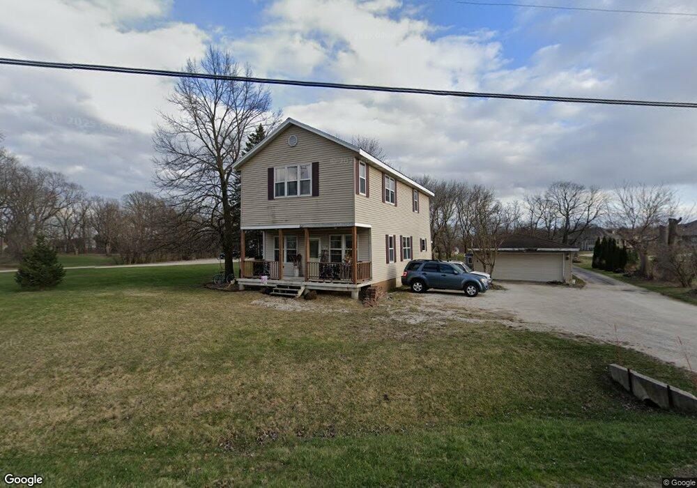
S79W16503 Woods Rd Muskego, WI 53150
Estimated Value: $418,000 - $502,000
3
Beds
2
Baths
1,386
Sq Ft
$329/Sq Ft
Est. Value
About This Home
This home is located at S79W16503 Woods Rd, Muskego, WI 53150 and is currently estimated at $455,503, approximately $328 per square foot. S79W16503 Woods Rd is a home located in Waukesha County with nearby schools including Lake Denoon Middle School, Muskego High School, and St. Leonard School.
Ownership History
Date
Name
Owned For
Owner Type
Purchase Details
Closed on
Jul 31, 1996
Sold by
Foshey James Carl and Foshey Maria
Bought by
Foshey Jon and Foshey Mayna
Current Estimated Value
Home Financials for this Owner
Home Financials are based on the most recent Mortgage that was taken out on this home.
Original Mortgage
$95,000
Interest Rate
8.27%
Create a Home Valuation Report for This Property
The Home Valuation Report is an in-depth analysis detailing your home's value as well as a comparison with similar homes in the area
Home Values in the Area
Average Home Value in this Area
Purchase History
| Date | Buyer | Sale Price | Title Company |
|---|---|---|---|
| Foshey Jon | $100,000 | -- |
Source: Public Records
Mortgage History
| Date | Status | Borrower | Loan Amount |
|---|---|---|---|
| Closed | Foshey Jon | $95,000 |
Source: Public Records
Tax History Compared to Growth
Tax History
| Year | Tax Paid | Tax Assessment Tax Assessment Total Assessment is a certain percentage of the fair market value that is determined by local assessors to be the total taxable value of land and additions on the property. | Land | Improvement |
|---|---|---|---|---|
| 2024 | $3,766 | $290,000 | $109,600 | $180,400 |
| 2023 | $4,217 | $290,000 | $109,600 | $180,400 |
| 2022 | $4,116 | $290,000 | $109,600 | $180,400 |
| 2021 | $4,010 | $290,000 | $109,600 | $180,400 |
| 2020 | $4,301 | $246,100 | $95,100 | $151,000 |
| 2019 | $4,317 | $246,100 | $95,100 | $151,000 |
| 2018 | $4,347 | $246,100 | $95,100 | $151,000 |
| 2017 | $4,355 | $246,100 | $95,100 | $151,000 |
| 2016 | $4,328 | $217,800 | $90,900 | $126,900 |
| 2015 | $4,371 | $217,800 | $90,900 | $126,900 |
| 2014 | $3,713 | $217,800 | $90,900 | $126,900 |
| 2013 | $3,713 | $217,800 | $90,900 | $126,900 |
Source: Public Records
Map
Nearby Homes
- S78W16730 Spinnaker Dr
- W169S7647 Gregory Dr Unit D
- W170S7579 Gregory Dr Unit H
- N51W19119 Quietwood Dr
- Lt4 Lannon Dr
- W163S7358 Bay Lane Dr
- W170S7361 Parkland Dr Unit 13
- W171S7452 Lannon Dr
- S75W17553 Harbor Cir Unit 1B
- S73W17268 Lake Dr
- S83W17591 Cedarcrest Ln
- W179S7953 Scenic Dr
- W177S7495 Harbor Cir Unit 6D
- S76W15088 Roger Dr
- W162S7043 Olive Cir Unit 22
- W186S7576 Kingston Dr
- S88W17993 Edgewater Heights Way
- S70W14897 Cornell Cir
- W188S7634 Oak Grove Dr
- W188S7598 Oak Grove Dr
- S79W16459 Woods Rd
- S79W16589 Green Ct
- S79W16588 Green Ct
- S79W16619 Green Ct Unit S79W16619
- S79W16556 Ruth Ln
- S79W16560 Ruth Ln
- S79W16564 Ruth Ln
- S79W16552 Ruth Ln
- S80W16590 Ruth Ln
- S79W16618 Green Ct
- W163S7957 Bay Lane Place
- W163S7943 Bay Lane Place
- W163S7921 Bay Lane Place
- S80W16586 Ruth Ln
- S79W16651 Green Ct
- W163S7935 Bay Lane Place
- S79W16655 Woods Rd
- S78W16499 Spinnaker Dr
- S79W16658 Green Ct
- W163S7973 Bay Lane Place