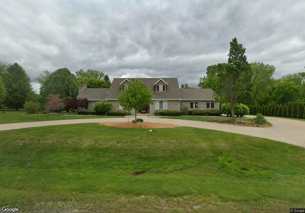
S84W24615 Pheasant Hill Rd Mukwonago, WI 53149
Estimated Value: $582,000 - $790,000
--
Bed
--
Bath
--
Sq Ft
1
Acres
About This Home
This home is located at S84W24615 Pheasant Hill Rd, Mukwonago, WI 53149 and is currently estimated at $662,350. S84W24615 Pheasant Hill Rd is a home located in Waukesha County with nearby schools including Big Bend Elementary School, Park View Middle School, and Mukwonago High School.
Ownership History
Date
Name
Owned For
Owner Type
Purchase Details
Closed on
Aug 3, 2020
Sold by
Rupinski Connie J
Bought by
Garza Elesha
Current Estimated Value
Home Financials for this Owner
Home Financials are based on the most recent Mortgage that was taken out on this home.
Original Mortgage
$355,000
Outstanding Balance
$314,910
Interest Rate
3%
Mortgage Type
New Conventional
Estimated Equity
$347,440
Purchase Details
Closed on
Jan 19, 2017
Sold by
Rupinski Lawrence S
Bought by
Rupinski Connie J
Create a Home Valuation Report for This Property
The Home Valuation Report is an in-depth analysis detailing your home's value as well as a comparison with similar homes in the area
Home Values in the Area
Average Home Value in this Area
Purchase History
| Date | Buyer | Sale Price | Title Company |
|---|---|---|---|
| Garza Elesha | $515,000 | None Available | |
| Rupinski Connie J | $350,000 | -- |
Source: Public Records
Mortgage History
| Date | Status | Borrower | Loan Amount |
|---|---|---|---|
| Open | Garza Elesha | $355,000 |
Source: Public Records
Tax History Compared to Growth
Tax History
| Year | Tax Paid | Tax Assessment Tax Assessment Total Assessment is a certain percentage of the fair market value that is determined by local assessors to be the total taxable value of land and additions on the property. | Land | Improvement |
|---|---|---|---|---|
| 2024 | $4,150 | $511,500 | $112,700 | $398,800 |
| 2023 | $4,037 | $511,500 | $112,700 | $398,800 |
| 2022 | $4,506 | $408,200 | $103,700 | $304,500 |
| 2021 | $4,455 | $408,200 | $103,700 | $304,500 |
| 2020 | $4,513 | $408,200 | $103,700 | $304,500 |
| 2019 | $4,338 | $351,200 | $90,200 | $261,000 |
| 2018 | $4,363 | $351,200 | $90,200 | $261,000 |
| 2017 | $4,910 | $351,200 | $90,200 | $261,000 |
| 2016 | $4,315 | $351,200 | $90,200 | $261,000 |
| 2015 | $4,226 | $351,200 | $90,200 | $261,000 |
| 2014 | $4,616 | $0 | $0 | $0 |
| 2013 | $4,616 | $354,900 | $91,000 | $263,900 |
Source: Public Records
Map
Nearby Homes
- W255S8545 Hi lo Dr
- S80W23790 Parkview Dr
- W247S7405 Scotland Dr
- W232S8430 Rosemary Dr
- W232S8755 Edgewood Ct
- S88W23155 Wynn Dr
- S76W25745 Prairieside Dr
- S94W23620 Kunzendorf Ct
- Lt0-Lt1 Wisconsin 164
- Pcl0 Clark St
- W247S6795 Sugar Maple Dr
- S71W23350 National Ave
- S95W23000 River Oaks Dr
- W237S6815 Fernwood Dr
- W264S7415 Mount Whitney Ave
- S96W22870 River Oaks Dr
- W240S10240 Castle Rd
- Lt0 Oakdale Dr
- W254S6500 Mcgregor Ct
- W249S6145 Deerfield Cir
- S84W24665 Pheasant Hill Rd
- S84W24670 Pheasant Hill Rd
- S84W24620 Pheasant Hill Rd
- S84W24585 Pheasant Hill Rd
- S84W24675 Pheasant Hill Rd
- W245S8465 Woodgate Rd
- S84W24600 Pheasant Hill Rd
- W245S8485 Woodgate Rd
- S84W24580 Pheasant Hill Rd
- S84W24685 Pheasant Hill Rd
- S84W24695 Pheasant Hill Rd
- S84W24540 Pheasant Hill Rd
- W245S8430 Woodgate Rd
- W245S8480 Woodgate Rd
- S84W24505 Pheasant Hill Rd
- W247S8340 Stonehill Dr
- S84W24500 Pheasant Hill Rd
- S84W24705 Pheasant Hill Rd
- S83W24605 Artesian Ave
- S83W24555 Artesian Ave