


State Road 17 North St Kewanna, IN 46939
Estimated payment $4,367/month
73.44
Acres
$10,551
Price per Acre
3,199,046
Sq Ft Lot
Highlights
- 1,454 Feet of Waterfront
- Agricultural
- Creek or Stream
- 73.44 Acre Lot
About This Lot
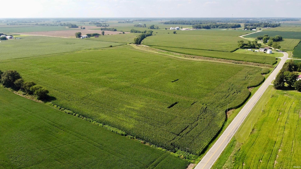
This property offers an excellent combination of productive farmland and potential building sites. Divided into three separate tracts, this property features 66.37± acres of tillable ground comprised of loamy sand, sandy clay loam, sandy loam, silt loam, and muck soils, with an average NCCPI of 66.75 and a corn WAPI of 141.6. The ground has been well maintained in a corn and soybean rotation and will have open tenancy for the 2026 crop year, providing flexibility for a new owner to farm or lease for income. Road frontage along both a state and county road ensures easy access for farm equipment, trucks, and potential driveways for home sites. Little Mill Creek runs through part of the property, adding a reliable water feature. Several different locations on the property would make excellent sites for a new home, offering space, privacy, and views of the surrounding farmland. Whether you’re a local farmer looking to expand your operation, an investor seeking quality row crop ground, or a buyer dreaming of building a home in the country, this property delivers. Its combination of high-quality soils, strong yield potential, and prime location makes it a rare find in today’s market.
Listing Agent
Whitetail Properties Real Estate Brokerage Phone: 574-225-2699 Listed on: 08/20/2025
Property Details
Property Type
- Land
Est. Annual Taxes
- $1,744
Lot Details
- 73.44 Acre Lot
- Lot Dimensions are 1312 x 2653
- 1,454 Feet of Waterfront
- Property fronts a state road
- Creek or Stream
- Rural Setting
- Barbed Wire
- Finished Lot(s)
- Subdivision Possible
- Land Lease
Parking
- Driveway
Schools
- Columbia / Riddle Elementary School
- Rochester Community Middle School
- Rochester Community High School
Farming
- Agricultural
Listing and Financial Details
- Assessor Parcel Number 25-05-16-400-001.010-013
Map
Create a Home Valuation Report for This Property
The Home Valuation Report is an in-depth analysis detailing your home's value as well as a comparison with similar homes in the area
Home Values in the Area
Average Home Value in this Area
Property History
| Date | Event | Price | Change | Sq Ft Price |
|---|---|---|---|---|
| 08/20/2025 08/20/25 | For Sale | $774,900 | -- | -- |
Source: Indiana Regional MLS
Similar Property in Kewanna, IN
Source: Indiana Regional MLS
MLS Number: 202533156
Disclaimer: Certain information contained herein is derived from information provided by parties other than Homes.com. All information provided is deemed reliable, but is not guaranteed to be accurate and should be independently verified.
![]() IDX information is provided exclusively for personal, non-commercial use, and may not be used for any purpose other than to identify prospective properties consumers may be interested in purchasing. Information is deemed reliable but not guaranteed.
IDX information is provided exclusively for personal, non-commercial use, and may not be used for any purpose other than to identify prospective properties consumers may be interested in purchasing. Information is deemed reliable but not guaranteed.
Nearby Homes
- 212 E Main St
- 418 N Troutman St Unit 10
- 417 S Toner St
- N State Road 17 Unit LotWP001
- 3631 S 700 E
- N County Road 850 W Unit LotWP001
- N 850 W County Rd
- 11016 W Silver Maple Dr
- 11446 S Park Rd
- 11905 W Pearl St
- 1432 N Lake Shore Dr
- 1500 N Lake Shore Dr
- 1199 N Main St
- 1228 N Main St
- 1241 N Main St
- 4517 W 100 S
- 1878 N 675 E
- 7254 S State Road 17
- 1530 N 400 W
- 2100 S 325 E