
Seller's Agent in 2025
Karen Talley
Clear Creek Realty
(406) 596-0123
45 Total Sales

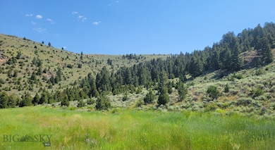
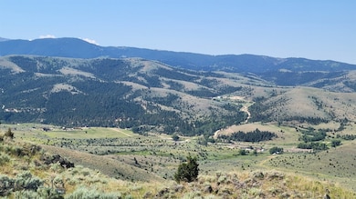
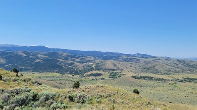
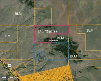
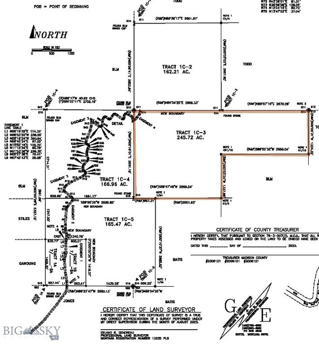
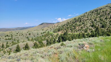
Spacious Tract 1C-3 - 245.72 acres available just outside and west of Historic Virginia City! This parcel is adjacent to BLM land know for its hunting and home to Elk. Located near the end of a private, grated road, this property has access points to two separate parcels of BLM, fantastic views, Pine trees and a road grated thru it that is not for other to use that makes access to many great building sites incredible easy. This property is located in the northern Gravelly Range with views east toward Virginia City and surrounding mountains ranges, Baldy Mountain and southwest toward the upper Ruby Valley toward the reservoir and the nearby Ruby Range. Privacy and quiet are a given. Solar with the southern facing slope in many places, and propane are a great option for services to your new cabin or home. So many places to explore from here with the Tobacco Root Mountain Range to the North, Gravelly and Snowcrest Mountain Ranges to the south and the nearby Ruby Mountains just west, host the Ruby Reservoir, Ruby River and thousands of more acres to explore. Livestock is allowed. Minor covenants or deed restrictions will be created (no mobile or manufactured homes allowed, no unlicensed or non-operable vehicles or equipment cannot be stored on property outside of a shop building, etc). Call for more information and a showing today!
Last Agent to Sell the Property
Clear Creek Realty License #BRO-8125 Listed on: 08/30/2023
| Date | Type | Sale Price | Title Company |
|---|---|---|---|
| Warranty Deed | -- | Flying S Title And Escrow | |
| Warranty Deed | -- | Flying S Title And Escrow | |
| Warranty Deed | -- | None Listed On Document |
| Date | Status | Loan Amount | Loan Type |
|---|---|---|---|
| Open | $440,000 | New Conventional |
| Date | Event | Price | List to Sale | Price per Sq Ft |
|---|---|---|---|---|
| 07/31/2025 07/31/25 | Sold | -- | -- | -- |
| 06/21/2025 06/21/25 | Pending | -- | -- | -- |
| 08/21/2024 08/21/24 | Price Changed | $749,000 | -4.0% | -- |
| 08/31/2023 08/31/23 | For Sale | $780,000 | -- | -- |
| Year | Tax Paid | Tax Assessment Tax Assessment Total Assessment is a certain percentage of the fair market value that is determined by local assessors to be the total taxable value of land and additions on the property. | Land | Improvement |
|---|---|---|---|---|
| 2025 | $87 | $21,476 | $0 | $0 |
| 2024 | $208 | $39,861 | $0 | $0 |
| 2023 | $737 | $44,932 | $0 | $0 |
| 2022 | $172 | $41,991 | $0 | $0 |
| 2021 | $182 | $40,400 | $0 | $0 |
| 2020 | $941 | $36,760 | $0 | $0 |
| 2019 | $948 | $36,760 | $0 | $0 |
| 2018 | $940 | $34,852 | $0 | $0 |
| 2017 | $175 | $34,852 | $0 | $0 |
| 2016 | $1,012 | $38,135 | $0 | $0 |
| 2015 | $190 | $38,135 | $0 | $0 |
| 2014 | $276 | $52,535 | $0 | $0 |
Seller's Agent in 2025
Karen Talley
Clear Creek Realty
(406) 596-0123
45 Total Sales
K
Seller Co-Listing Agent in 2025
Kimberli Campbell
Clear Creek Realty
(406) 565-7220
30 Total Sales
Buyer's Agent in 2025
Dawn Myrvik
PureWest Real Estate Ennis
(406) 541-4000
143 Total Sales
Source: Big Sky Country MLS
MLS Number: 385534
APN: 25-0421-14-2-01-01-0000
Disclaimer: Certain information contained herein is derived from information provided by parties other than Homes.com. All information provided is deemed reliable, but is not guaranteed to be accurate and should be independently verified.
![]() IDX information is provided exclusively for consumers' personal, non-commercial use, that it may not be used for any purpose other than to identify prospective properties consumers may be interested in purchasing, and that the data is deemed reliable but is not guaranteed accurate by the MLS.
IDX information is provided exclusively for consumers' personal, non-commercial use, that it may not be used for any purpose other than to identify prospective properties consumers may be interested in purchasing, and that the data is deemed reliable but is not guaranteed accurate by the MLS.